
Датотека:Iron Curtain map.svg

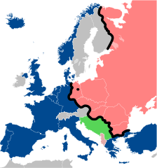
Veličina PNG pregleda za ovu SVG datoteku je 560 × 599 piksela. 6 drugih rezolucija: 224 × 240 piksela | 449 × 480 piksela | 718 × 768 piksela | 957 × 1.024 piksela | 1.914 × 2.048 piksela | 645 × 690 piksela.
Originalna datoteka (SVG datoteka, nominalno 645 × 690 piksela, veličina: 322 kB)
| Ovo je datoteka sa Vikimedijine ostave. Informacije sa njene stranice sa opisom prikazane su ispod. Vikimedijina ostava je skladište slobodno licenciralnih multimedijalnih datoteka. I Vi možete da pomognete. |
Opis izmene
| Opis |
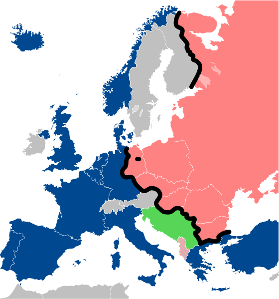
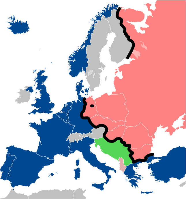
Lëtzebuergesch: Kaart vum Westen an dem Ostblock an Europa während dem Kale Krich.
"Eise Rido"
Neutral Länner
|
||
| Datum | |||
| Izvor |
Travail personnel (own work). Sources:
|
||
| Autor | Sémhur | ||
| Ostale verzije |
File:Iron Curtain map alternative.svg (Same, but with Yugoslavia on the Eastern side of the Iron Curtain.) | ||
| Autorstvo (required by the license) | © Sémhur / Wikimedia Commons / | ||
| SVG | W3C-validity not checked.
|
||
| Graphic Lab |

| Положај камере | | Ова и друге слике снимљене у близини на: OpenStreetMap |
|---|
Licenciranje
Ja, nosilac autorskih prava nad ovim delom, objavljujem isto pod sledećim licencama:
| Copyleft: This work of art is free; you can redistribute it and/or modify it according to terms of the Free Art License. You will find a specimen of this license on the Copyleft Attitude site as well as on other sites. |
This file is licensed under the Creative Commons Attribution-Share Alike Attribution-Share Alike 4.0 International, 3.0 Unported, 2.5 Generic, 2.0 Generic and 1.0 Generic license.
- Dozvoljeno je:
- da delite – da umnožavate, raspodeljujete i prenosite delo
- da prerađujete – da preradite delo
- Pod sledećim uslovima:
- autorstvo – Morate da date odgovarajuće zasluge, obezbedite vezu ka licenci i naznačite da li su izmene napravljene. Možete to uraditi na bilo koji razuman manir, ali ne na način koji predlaže da licencator odobrava vas ili vaše korišćenje.
- deliti pod istim uslovima – Ako izmenite, preobrazite ili dogradite ovaj materijal, morate podeliti svoje doprinose pod istom ili kompatibilnom licencom kao original.
Izaberite licencu po želji.
Istorija datoteke
Kliknite na datum/vreme da biste videli tadašnju verziju datoteke.
| Datum/vreme | Minijatura | Dimenzije | Korisnik | Komentar | |
|---|---|---|---|---|---|
| trenutna | 15:26, 15. decembar 2022. | | 645 × 690 (322 kB) | PhotographyEdits | Extend the Iron Curtain eastwards of Yugoslavia. Even though Yugoslavia was not really considered part of the West, the currenet map gives the false impression that there was a huge gap in the Iron Curtain, which wasn't the case. |
| 02:56, 23. jul 2022. |  | 645 × 690 (321 kB) | Kwamikagami | NATO blue, #004990 | |
| 22:30, 30. mart 2019. |  | 645 × 690 (321 kB) | Sémhur | Reverted to version as of 07:07, 27 May 2014 (UTC). Albania leaves the Waras Pack in middle of cold war; this is why it's shown wtih stripes. | |
| 11:18, 24. mart 2019. |  | 512 × 548 (123 kB) | Hakuli | Albania leaves the Waras Pack in middle of cold war | |
| 09:07, 27. maj 2014. |  | 645 × 690 (321 kB) | Sémhur | Valid SVG | |
| 15:51, 16. novembar 2010. |  | 645 × 690 (321 kB) | Sémhur | Added Iron Curtain between Bulgaria and Greece & Turkey. | |
| 18:57, 27. septembar 2008. |  | 645 × 690 (321 kB) | Sémhur | Correcting mistake : Austria wasn't in NATO. | |
| 12:51, 31. maj 2008. |  | 645 × 690 (330 kB) | Sémhur | {{Information |Description={{en|1=Map of the Iron Curtain in Europe.}} {{fr|1=Carte du rideau de fer en Europe.}} {{es|1=Mapa del Telón de Acero en Europa.}} |Source=Travail personnel (ow |
Upotreba datoteke
4 sledeće stranice koriste ovu datoteku:
Globalna upotreba datoteke
Drugi vikiji koji koriste ovu datoteku:
- Upotreba na af.wikipedia.org
- Upotreba na als.wikipedia.org
- Upotreba na ar.wikipedia.org
- Upotreba na ast.wikipedia.org
- Upotreba na azb.wikipedia.org
- Upotreba na az.wikipedia.org
- Upotreba na ba.wikipedia.org
- Upotreba na be-tarask.wikipedia.org
- Upotreba na be.wikipedia.org
- Upotreba na bg.wikipedia.org
- Upotreba na br.wikipedia.org
- Upotreba na bs.wikipedia.org
- Upotreba na ca.wikipedia.org
- Upotreba na cs.wikipedia.org
- Upotreba na cy.wikipedia.org
- Upotreba na da.wikipedia.org
- Upotreba na de.wikipedia.org
- Upotreba na el.wikipedia.org
- Upotreba na el.wiktionary.org
- Upotreba na en.wikipedia.org
- Upotreba na en.wikibooks.org
- Upotreba na en.wikiquote.org
Još globalnog korišćenja ove datoteke.