| ОписDelta on Mars.jpg |
Čeština: Říční delta v bezejmeném kráteru na jižní polokouli Marsu
Ελληνικά: Αρχαίο δέλτα ποταμού στην περιοχή του κρατήρα Έμπερσβαλντε στον πλανήτη Άρη. Φωτογραφία του Mars Global Surveyor. Η φωτογραφία αποτελεί μια από τις πρώτες αποδείξεις ότι στον Άρη υπήρξαν, παλαιότερα, περιοχές όπου μόνιμα υπήρχε νερό σε υγρή μορφή, όπως λίμνες.
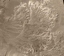
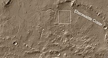
English: River delta in Eberswalde crater on the surface of Mars. Picture size 13x11 km, picture by the Mars Global Surveyor. Located at 24.3 S and 33.5 W.
Original caption released with image
This week, the journal Science has published online (in Science Express) the most recent MOC discovery: an ancient, eroded, and exhumed sedimentary distributary fan located in a crater at 24.3°S, 33.5°W. A distributary fan is a generic term used by geologists to describe a family of deposits that includes river deltas and alluvial fans. Sometime in the distant past, when it was still possible for liquid water to flow across the martian surface, sediments transported through valleys by water formed a fan-shaped deposit in a 64-kilometer (40 miles) -diameter crater northeast of Holden Crater.
What is important about this discovery? First, it provides clear, unequivocal evidence that some valleys on Mars experienced the same type of on-going, or, persistent, flow over long periods of time as rivers do on Earth. Second, because the fan is today a deposit of sedimentary rock, it demonstrates that some sedimentary rocks on Mars were, as has been suspected but never clearly demonstrated, deposited in a liquid (probably water) environment. Third, the general shape, pattern of its channels, and low topographic slopes provide circumstantial evidence that the feature was actually a delta--that is, a deposit made when a river or stream enters a body of water. In other words, the landform discovered by MOC may be the strongest indicator yet that some craters and other depressions on Mars once held lakes. Although hundreds of other locations on Mars where valleys enter craters and basins have been imaged by MOC, this is the first to show landforms like those presented here.
The picture, MOC2-543a, is a mosaic of MOC high resolution images acquired between August 2000 and September 2003. The area covered is 14 km (8.7 mi) wide and 19.3 km (12 mi) high; north is up and the scene is illuminated by sunlight from the left. The MOC NA camera takes grayscale images; the color added to this and the other images was derived from data collected nearby using the Thermal Emission Imaging System (THEMIS) Visible Imaging Subsystem (built by Malin Space Science Systems for Arizona State University) on-board the Mars Odyssey spacecraft. The picture shows the entire distributary fan. The fan is a fossil landform--that is, it is an eroded remnant of a somewhat larger, somewhat thicker deposit. The originally loose sediment has been turned to rock and then eroded over time to present the features seen today. The channels through which sediment was transported are no longer present; instead, only their floors have remained, and these have been elevated by erosion so that former channels now stand as ridges. The floors of former channels became inverted because they were more resistant to the forces of erosion---either they were more strongly cemented than the surrounding materials, or they have more coarse grains (which are harder to remove), or both. |


