
Датотека:Granger Stage Station.jpg

Величина овог приказа: 800 × 559 пиксела. 3 друге резолуције: 320 × 224 пиксела | 640 × 447 пиксела | 956 × 668 пиксела.
Оригинална датотека (956 × 668 пиксела, величина датотеке: 73 kB, MIME тип: image/jpeg)
| Ово је датотека са Викимедијине оставе. Информације са њене странице са описом приказане су испод. Викимедијина остава је складиште слободно лиценциралних мултимедијалних датотека. И Ви можете да помогнете. |
|
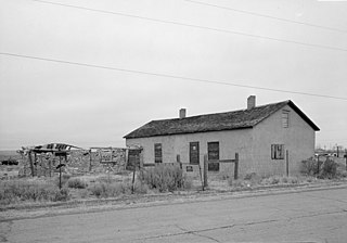
This is an image of a place or building that is listed on the National Register of Historic Places in the United States of America. Its reference number is 70000678. |
| Положај камере | | Ова и друге слике снимљене у близини на: OpenStreetMap |
|---|
| Опис |
English: Front of the Granger Station, a former stagecoach station located along Old U.S. Route 30 in Granger, Wyoming, United States. Built in 1856, the station is listed on the National Register of Historic Places. |
|||||
| Датум | Непознат датум | |||||
| Извор | Library of Congress, Prints and Photograph Division HABS: WYO,19-GRANG,1-1 | |||||
| Аутор | Непознат | |||||
| Дозвола (Поновно коришћење ове датотеке) |
|


|
This image is available from the United States Library of Congress's Prints and Photographs division
under the digital ID hhh.wy0029. This tag does not indicate the copyright status of the attached work. A normal copyright tag is still required. See Commons:Licensing.
|
Историја датотеке
Кликните на датум/време да бисте видели тадашњу верзију датотеке.
| Датум/време | Минијатура | Димензије | Корисник | Коментар | |
|---|---|---|---|---|---|
| тренутна | 20:20, 28. април 2009. | | 956 × 668 (73 kB) | Cropbot | upload cropped version, operated by User:Finavon. Summary: border cropped |
| 17:32, 25. април 2009. |  | 1.024 × 728 (83 kB) | Nyttend | {{Location|41|35|25|N|109|58|8|W}} {{Information |Description={{en|Front of the {{w|Granger Station}}, a former {{w|stagecoach}} station located along Old {{w|U.S. Route 30}} in {{w|Granger, Wyoming|Granger}}, {{w|Wyoming}}, {{w|United States}}. Built in |
Употреба датотеке
Следећа страница користи ову датотеку:
Глобална употреба датотеке
Други викији који користе ову датотеку:
- Употреба на azb.wikipedia.org
- Употреба на de.wikipedia.org
- Употреба на en.wikipedia.org
- Употреба на fa.wikipedia.org
- Употреба на pt.wikipedia.org
- Употреба на sh.wikipedia.org
- Употреба на sv.wikipedia.org
- Употреба на uk.wikipedia.org
- Употреба на zh-min-nan.wikipedia.org