Датотека:ISS018-E-038182 lrg.jpg
Садржај странице није подржан на другим језицима
Ово је датотека са Викимедијине оставе
С Википедије, слободне енциклопедије

Оригинална датотека(1.440 × 960 пиксела, величина датотеке: 689 kB, MIME тип: image/jpeg)

Опис измене

Опис
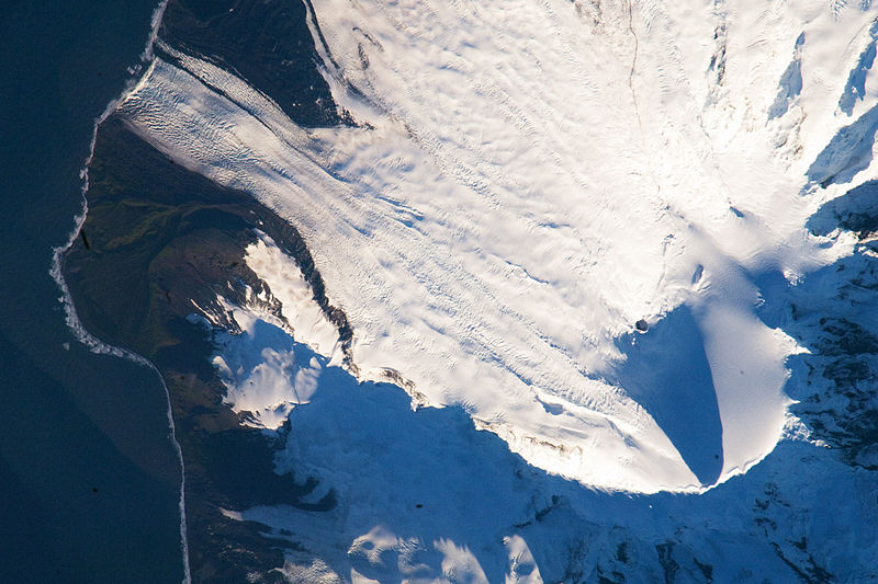
English: Heard Island is located in the southern Indian Ocean, approximately 1,550 kilometers (963 miles) north of Antarctica. The island is a visible part of the Kerguelen Plateau, a submerged feature on the seafloor. The plateau was formed when large amounts of volcanic rock erupted over a geologically short time period. (When large amounts of volcanic rock erupt beneath the ocean from processes other than seafloor spreading, geologists refer to them as large igneous provinces.) Most of Heard Island is formed from volcanic rocks associated with the Big Ben stratovolcano. The northeastern slopes of the volcano are visible in shadow at the lower right of this detailed astronaut photograph.

Recent volcanic activity at Heard Island has occurred at 2,745-meter (9,006-foot) Mawson Peak, which sits within a breached caldera on the southwestern side of the Big Ben Volcano. Calderas form when a magma chamber beneath a volcano empties and collapses. The shadow cast by Mawson Peak points directly to the crescent-shaped caldera rim. Detailed geologic study of Big Ben Volcano is complicated by the presence of several glaciers, including Gotley and Lied Glaciers on the southwestern slopes. This image, taken during Southern Hemisphere summer, also reveals non-glaciated volcanic rock (light to dark brown) on either side of Gotley Glacier.


International Space Station InsigniaISS Crew Earth Observations: ISS018-E-038182International Space Station Insignia
Identification
Mission ISS018 (Expedition 18)
Roll E
Frame 038182
Country or Geographic Name ANTARCTICA
Features S.W. AREA OF HEARD I., MAWSON PEAK, FREMANTLE PEAK
Center Point Latitude -53.1° N
Center Point Longitude 73.5° E
Camera
Camera Tilt 36°
Camera Focal Length 800 mm
Camera Nikon D2Xs
Film 4288 x 2848 pixel CMOS sensor, RGBG imager color filter.
Quality
Percentage of Cloud Cover 0-10%
Nadir What is Nadir?
Date 2009-02-28
Time 12:54:41
Nadir Point Latitude -51.3° N
Nadir Point Longitude 71.9° E
Nadir to Photo Center Direction Southeast
Sun Azimuth 271°
Spacecraft Altitude 197 nautical miles (365 km)
Sun Elevation Angle 11°
Orbit Number 2885
Датум
Извор http://earthobservatory.nasa.gov/IOTD/view.php?id=37488&src=iotdrss
Аутор Astronaut photograph ISS018-E-38182 was acquired on February 28, 2009, with a Nikon D2Xs digital camera fitted with an 800 mm lens, and is provided by the ISS Crew Earth Observations experiment and the Image Science & Analysis Laboratory, Johnson Space Center. The image was taken by the Expedition 18 crew. The image in this article has been cropped and enhanced to improve contrast. Lens artifacts have been removed. The International Space Station Program supports the laboratory to help astronauts take pictures of Earth that will be of the greatest value to scientists and the public, and to make those images freely available on the Internet. Additional images taken by astronauts and cosmonauts can be viewed at the NASA/JSC Gateway to Astronaut Photography of Earth. Caption William L. Stefanov, NASA-JSC.

Лиценцирање

Public domain Ова датотека је у јавном власништву зато што је њен аутор НАСА. НАСА-а политика ауторских права наводи „Материјали НАСА-е нису заштићени ауторским правима осим ако није другачије наведено“. (Погледајте Template:PD-USGov, NASA copyright policy page или JPL Image Use Policy.)
Упозорења:
  • Употреба НАСА-их логотипа и емблема је ограничена Америчким законом 14 CFR 1221.
  • НАСА-ин сајт хостује велики број слика Совјетске/Руске свемирске агенције и других не-Америчких свемирских агенција. Ове слике нису нужно у јавном власништву.
  • Материјали засновани на подацима Хабл телескопа су слободни само ако је њихов аутор STScI.[1] Такође погледајте {{PD-Hubble}} и {{Cc-Hubble}}.
  • Материјали са сонде SOHO су заштићени ауторским правима и потребна је дозвола за комерцијалну употребу. [2]
  • Слике са сајта APOD можда подлежу ауторским правима. [3]

Натписи

Укратко објашњење шта ова датотека представља/приказује

Ставке приказане у овој датотеци

приказује

Heard Island енглески

28. фебруар 2009

Историја датотеке

Кликните на датум/време да бисте видели тадашњу верзију датотеке.

Датум/времеМинијатураДимензијеКорисникКоментар
тренутна05:57, 16. март 2009.Минијатура за верзију на дан 05:57, 16. март 2009.1.440 × 960 (689 kB)Shizhao{{Information |Description={{en|1=Heard Island is located in the southern Indian Ocean, approximately 1,550 kilometers (963 miles) north of Antarctica. The island is a visible part of the Kerguelen Plateau, a submerged feature on the seafloor. The plateau

Следећа страница користи ову датотеку:

Глобална употреба датотеке

Други викији који користе ову датотеку:

Још глобалног коришћења ове датотеке.

Метаподаци