
Датотека:Iceland Mid-Atlantic Ridge map.svg

Величина PNG прегледа за ову SVG датотеку је 376 × 390 пиксела. 5 других резолуција: 231 × 240 пиксела | 463 × 480 пиксела | 740 × 768 пиксела | 987 × 1.024 пиксела | 1.974 × 2.048 пиксела.
Оригинална датотека (SVG датотека, номинално 376 × 390 пиксела, величина: 129 kB)
| Ово је датотека са Викимедијине оставе. Информације са њене странице са описом приказане су испод. Викимедијина остава је складиште слободно лиценциралних мултимедијалних датотека. И Ви можете да помогнете. |
Опис измене
| Опис | |
| Датум | |
| Извор | http://pubs.usgs.gov/gip/dynamic/understanding.html |
| Аутор | http://pubs.usgs.gov/gip/dynamic/understanding.html |
| Остале верзије |
|


Лиценцирање
This image is in the public domain in the United States because it only contains materials that originally came from the United States Geological Survey, an agency of the United States Department of the Interior. For more information, see the official USGS copyright policy.
|
| Annotations | This image is annotated: View the annotations at Commons |
Историја датотеке
Кликните на датум/време да бисте видели тадашњу верзију датотеке.
| Датум/време | Минијатура | Димензије | Корисник | Коментар | |
|---|---|---|---|---|---|
| тренутна | 20:48, 10. јануар 2014. | | 376 × 390 (129 kB) | Amitchell125 | text improved |
| 16:42, 26. фебруар 2010. |  | 376 × 390 (68 kB) | Beao | Tweak. | |
| 16:40, 26. фебруар 2010. |  | 376 × 390 (68 kB) | Beao | Tweak. | |
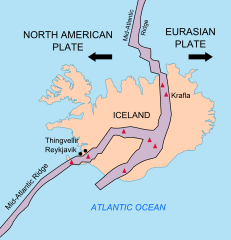
| 16:37, 26. фебруар 2010. |  | 376 × 390 (68 kB) | Beao | == Summary == {{Information |Description={{en|1=Map showing the Mid-Atlantic Ridge splitting Iceland and separating the North American and Eurasian Plates. The map also shows Reykjavik, the capital of Iceland, the Thingvellir area, and the locations of so |
Употреба датотеке
Следећа страница користи ову датотеку:
Глобална употреба датотеке
Други викији који користе ову датотеку:
- Употреба на be-tarask.wikipedia.org
- Употреба на bn.wikipedia.org
- Употреба на ca.wikipedia.org
- Употреба на en.wikipedia.org
- Употреба на en.wikivoyage.org
- Употреба на fi.wikipedia.org
- Употреба на hr.wikipedia.org
- Употреба на id.wikipedia.org
- Употреба на it.wikipedia.org
- Употреба на ko.wikipedia.org
- Употреба на lb.wikipedia.org
- Употреба на nl.wikipedia.org
- Употреба на no.wikipedia.org
- Употреба на pl.wikipedia.org
- Употреба на simple.wikipedia.org
- Употреба на sl.wikipedia.org
- Употреба на sv.wikipedia.org
- Употреба на tr.wikipedia.org
- Употреба на uk.wikipedia.org
- Употреба на zh.wikipedia.org
- Употреба на zh.wikivoyage.org