Pređi na sadržaj

Датотека:Comparison satellite navigation orbits.svg

Sadržaj stranice nije podržan na drugim jezicima
Ovo je datoteka sa Vikimedijine ostave
S Vikipedije, slobodne enciklopedije

Originalna datoteka(SVG datoteka, nominalno 512 × 512 piksela, veličina: 42 kB)

Renderuj ovu sliku u .
This image is an animated SVG file. The .png preview above created by RSVG for use in Wikimedia is not animated and may be incomplete or incorrect. To see the animation, open media:Comparison satellite navigation orbits.svg. It should run in any modern browser or viewer. Recent versions of Chrome, Firefox, Microsoft Edge, Safari, and Opera all support SVG animated with SMIL. Other SVG animations can be found at Category:Animated SVG files.

Templates:Animated SVG/I18n
العربية | Boarisch | বাংলা | català | čeština | Deutsch | Deutsch (Sie-Form)‎ | English | español | فارسی | suomi | français | galego | עברית | हिन्दी | magyar | հայերեն | íslenska | italiano | 日本語 | 한국어 | lietuvių | македонски | മലയാളം | Plattdüütsch | Nederlands | occitan | português | português do Brasil | русский | sicilianu | slovenščina | svenska | ไทย | українська | 中文 | 中文(简体)‎ | 中文(繁體)‎ | +/−

Opis izmene

Opis
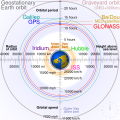
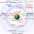
English: Comparison of GPS, GLONASS, Galileo and COMPASS (medium Earth orbit satellites) orbits with International Space Station, Hubble Space Telescope, geostationary and graveyard orbits, and the nominal size of the Earth.


For this diagram, the 3-dimensional aspect of orbits have been flattened. For instance, the view of the Earth depicted is looking down to the North Pole which makes the orbit representations appear to be equatorial. While this is accurate for geostationary orbits, other orbits listed are actually at significant inclinations. The inclination of Iridium orbits is at 86.4° which is nearly perpendicular to the diagrammed plane. Looking down to the North Pole from this zenith, a polar orbit of 90° inclination would actually appear as a straight line.
Français : Comparaison des orbites GPS, GLONASS, Galileo, Iridium et Beidou avec celles de la Station spatiale internationale et Hubble ainsi que l'orbite géostationnaire, l'orbite de rebut et la taille de la Terre.


Pour ce diagramme, l'aspect tridimensionnel des orbites a été ignoré : tout est aplati. La Terre est représentée avec le pôle Nord au centre, ce qui fait que les orbites semblent équatoriales. Ceci est correct dans le cas des orbites géostationnaires, mais les autres sont en réalité inclinées. Les satellites Iridium sont le cas le plus extrême, avec 86,4° d'inclinaison, les plaçant presque à la perpendiculaire du plan représenté. Si leur orbite était représentée de façon fidèle, nous ne verrions qu'une ligne droite sur ce diagramme.
Izvor Sopstveno delo
Autor cmglee
Ostale verzije

[uredi]

English: Animated
Español: Animada
Македонски: Анимирано
Русский: Мультипликация
Українська: Анімація
English: Static
Македонски: Обична слика
Русский: Обычная картинка
Українська: Статичне зображення
SVG genesis
InfoField
 
The SVG code is valid.
 
This diagram was created with unknown tool.
 
 This diagram is translated using SVG switch elements: all translations are stored in the same file.

Assessment

Media of the day This file was selected as the media of the day for 12 August 2020. It was captioned as follows:
English: A detailed and informative diagram that brings to life where different satellites (e.g. the International Space Station vs. the GPS satellites) are physically located relative to Earth
Other languages
Čeština: Detailní diagram ukazující, kde se na oběžné dráze kolem Země fyzicky nacházejí různé uměle vyrobené satelity, např. Mezinárodní vesmírná stanice nebo součásti sysému GPS.
English: A detailed and informative diagram that brings to life where different satellites (e.g. the International Space Station vs. the GPS satellites) are physically located relative to Earth
Français : Diagramme animé présentant les principales orbites des satellites artificiels autour de la Terre.

Featured media
This is a featured media on Wikimedia Commons and is considered one of the finest files.

If you have a file of similar quality that can be published under a suitable copyright license, be sure to upload it, tag it, and nominate it.

Vikipedija

 Ово је изабрана слика на Википедија на енглески језик (Featured pictures) and is considered one of the finest images.

Ако мислиш да ова датотека такође треба да буде изабрана на Викимедијиној остави предложи је.
Ако поседујете слику бољег или сличног квалитета коју сте вољни објавити под одговарајућом лиценцом, свакако је пошаљите, прописно означите и предложите je.

Licenciranje

Ja, nosilac autorskih prava nad ovim delom, objavljujem isto pod sledećim licencama:
w:sr:Krijejtiv komons
autorstvo deliti pod istim uslovima
Dozvoljeno je:
  • da delite – da umnožavate, raspodeljujete i prenosite delo
  • da prerađujete – da preradite delo
Pod sledećim uslovima:
  • autorstvo – Morate da date odgovarajuće zasluge, obezbedite vezu ka licenci i naznačite da li su izmene napravljene. Možete to uraditi na bilo koji razuman manir, ali ne na način koji predlaže da licencator odobrava vas ili vaše korišćenje.
  • deliti pod istim uslovima – Ako izmenite, preobrazite ili dogradite ovaj materijal, morate podeliti svoje doprinose pod istom ili kompatibilnom licencom kao original.
GNU head Data je dozvola da se kopira, distribuira i/ili menja ovaj dokument pod uslovima GNU-ove licence za slobodnu dokumentaciju, verzije 1.2 ili bilo koje novije verzije koju objavi Zadužbina za slobodni softver; bez nepromenljivih odeljaka i bez teksta na naslovnoj i zadnjoj strani. Tekst licence možete pročitati ovde.
Izaberite licencu po želji.
Annotations
InfoField
This image is annotated: View the annotations at Commons

Natpisi

Dodajte objašnjenje u jednom redu o tome šta ova datoteka predstavlja
Earth satellite orbits

Stavke prikazane u ovoj datoteci

prikazuje

orbita Serbian (transliteracija)

Međunarodna svemirska stanica Serbian (transliteracija)

COMPASS Serbian (transliteracija)

Compass English

Srednja Zemljina orbita Serbian (transliteracija)

Galileo Orbiter Serbian (transliteracija)

Van Alenov pojas Serbian (transliteracija)

Neka vrednost bez stavke na projektu Vikipodaci

skraćeno ime autora Serbian (transliteracija): cmglee
Vikimedija Serbian (transliteracija): Cmglee

status autorskog prava Serbian (transliteracija)

zaštićeno autorskim pravima Serbian (transliteracija)

izvor datoteke Serbian (transliteracija)

sopstveno delo Serbian (transliteracija)

kontrolna suma Serbian (transliteracija)

2cf5d382b563a0eac7ecd7322d221f0fb0d6bbbb

veličina podatka Serbian (transliteracija)

43.502 bajt

visina Serbian (transliteracija)

512 piksel

širina Serbian (transliteracija)

512 piksel

Istorija datoteke

Kliknite na datum/vreme da biste videli tadašnju verziju datoteke.

(najnovije | najstarije) Prikaži (novijih 10 | ) (10 | 20 | 50 | 100 | 250 | 500).
Datum/vremeMinijaturaDimenzijeKorisnikKomentar
trenutna06:48, 27. februar 2021.Minijatura za verziju na dan 06:48, 27. februar 2021.512 × 512 (42 kB)GlrxFix SVG errors: systemLanguage attr on desc element; misuse of switch element; use SVG 2.0 rules; delete DOCTYPE
16:49, 24. septembar 2020.Minijatura za verziju na dan 16:49, 24. septembar 2020.512 × 512 (43 kB)DrhymeFile uploaded using svgtranslate tool (https://svgtranslate.toolforge.org/). Added translation for ko.
16:44, 24. septembar 2020.Minijatura za verziju na dan 16:44, 24. septembar 2020.512 × 512 (40 kB)DrhymeFile uploaded using svgtranslate tool (https://svgtranslate.toolforge.org/). Added translation for ko.
16:35, 24. septembar 2020.Minijatura za verziju na dan 16:35, 24. septembar 2020.512 × 512 (36 kB)DrhymeFile uploaded using svgtranslate tool (https://svgtranslate.toolforge.org/). Added translation for ko.
21:41, 22. septembar 2020.Minijatura za verziju na dan 21:41, 22. septembar 2020.512 × 512 (29 kB)CmgleeReverted to version as of 18:10, 19 August 2020 (UTC) as text is now misaligned and descriptions are removed
13:31, 21. septembar 2020.Minijatura za verziju na dan 13:31, 21. septembar 2020.512 × 512 (23 kB)Leonel SohnsValid SVG.
20:10, 19. avgust 2020.Minijatura za verziju na dan 20:10, 19. avgust 2020.512 × 512 (29 kB)RavenpuffSpecify supplementary systemLanguage="en" in switch tags as per Commons guidance
03:11, 19. avgust 2020.Minijatura za verziju na dan 03:11, 19. avgust 2020.512 × 512 (25 kB)CmgleeFix broken hover effects and redundant text.
19:55, 30. jun 2020.Minijatura za verziju na dan 19:55, 30. jun 2020.512 × 512 (33 kB)Galaktoschange http: to https: (except in doctype or xmlns) and wikipedia.org to en.wikipedia.org
21:43, 23. jun 2020.Minijatura za verziju na dan 21:43, 23. jun 2020.512 × 512 (33 kB)CmgleeTry again
(najnovije | najstarije) Prikaži (novijih 10 | ) (10 | 20 | 50 | 100 | 250 | 500).

3 sledeće stranice koriste ovu datoteku:

Globalna upotreba datoteke

Drugi vikiji koji koriste ovu datoteku:

Još globalnog korišćenja ove datoteke.

Metapodaci