
Датотека:Ethnic Map of Hungary 1910 with Counties.png

Veličina ovog prikaza: 800 × 529 piksela. 6 drugih rezolucija: 320 × 212 piksela | 640 × 423 piksela | 1.024 × 677 piksela | 1.280 × 846 piksela | 2.560 × 1.692 piksela | 6.208 × 4.104 piksela.
Originalna datoteka (6.208 × 4.104 piksela, veličina datoteke: 1,41 MB, MIME tip: image/png)
| Ovo je datoteka sa Vikimedijine ostave. Informacije sa njene stranice sa opisom prikazane su ispod. Vikimedijina ostava je skladište slobodno licenciralnih multimedijalnih datoteka. I Vi možete da pomognete. |
Opis izmene
| Opis |
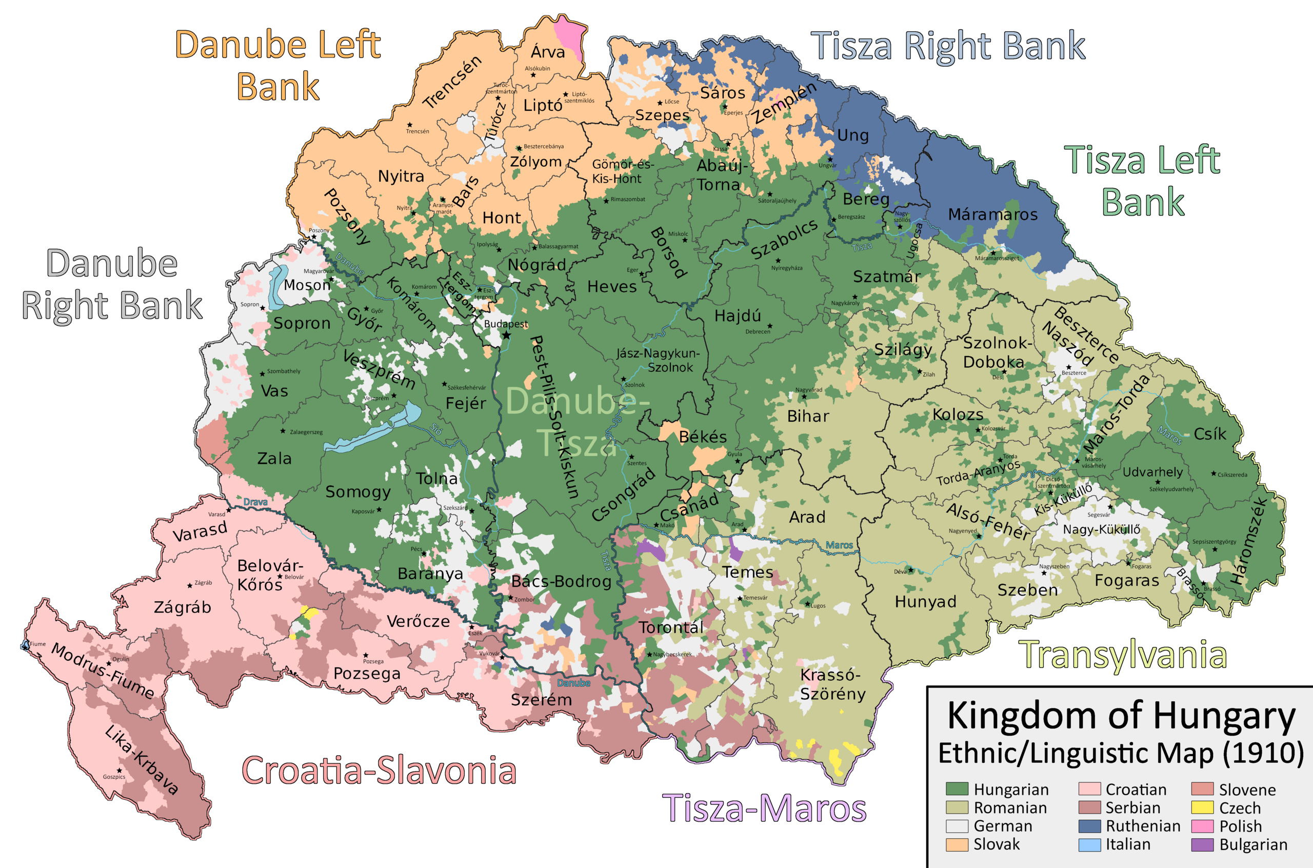
English: A map which shows the counties and larger regional subdivisions of the Kingdom of Hungary according to the 1910 census, with majority/plurality ethnicities indicated by color |
| Datum | |
| Izvor | Sopstveno delo |
| Autor | Ascended Dreamer |
Licenciranje
Ja, nosilac autorskog prava nad ovim delom, objavljujem isto pod sledećom licencom:
Ova datoteka je dostupna pod licencom Creative Commons Autorstvo-Deliti pod istim uslovima 4.0 Međunarodna.
- Dozvoljeno je:
- da delite – da umnožavate, raspodeljujete i prenosite delo
- da prerađujete – da preradite delo
- Pod sledećim uslovima:
- autorstvo – Morate da date odgovarajuće zasluge, obezbedite vezu ka licenci i naznačite da li su izmene napravljene. Možete to uraditi na bilo koji razuman manir, ali ne na način koji predlaže da licencator odobrava vas ili vaše korišćenje.
- deliti pod istim uslovima – Ako izmenite, preobrazite ili dogradite ovaj materijal, morate podeliti svoje doprinose pod istom ili kompatibilnom licencom kao original.
Istorija datoteke
Kliknite na datum/vreme da biste videli tadašnju verziju datoteke.
| Datum/vreme | Minijatura | Dimenzije | Korisnik | Komentar | |
|---|---|---|---|---|---|
| trenutna | 15:29, 22. septembar 2023. | | 6.208 × 4.104 (1,41 MB) | Ascended Dreamer | Change color of Slovene |
| 17:00, 22. jul 2023. |  | 6.208 × 4.104 (1,41 MB) | Ascended Dreamer | Correcting more errors noticed by Alphathon | |
| 23:26, 19. jul 2023. |  | 6.208 × 4.104 (1,41 MB) | Ascended Dreamer | Incorporating Corrections made by Alpathon | |
| 10:40, 19. jul 2023. |  | 6.208 × 4.104 (1,34 MB) | Alphathon | Applied (rough) corrections to Bars/Hont and Csongrád/Bács-Bodrog borders | |
| 01:02, 2. jul 2023. |  | 6.208 × 4.104 (1,41 MB) | Ascended Dreamer | Corrected location of Nagykároly | |
| 22:02, 27. april 2023. |  | 6.208 × 4.104 (1,41 MB) | Ascended Dreamer | Corrected color indicating Slovenes | |
| 03:18, 21. januar 2023. |  | 6.208 × 4.104 (1,41 MB) | Ascended Dreamer | Changed color of lakes to blue | |
| 00:33, 21. januar 2023. |  | 6.208 × 4.104 (1,41 MB) | Ascended Dreamer | Increased border accuracy | |
| 05:26, 16. januar 2023. |  | 6.208 × 4.104 (1,19 MB) | Ascended Dreamer | Added county capital names | |
| 22:44, 15. januar 2023. |  | 6.208 × 4.104 (975 kB) | Ascended Dreamer | Cleaned up map, fixed error, added small stars indicating county capital locations. Better to leave them unlabeled? |
Upotreba datoteke
Sledeća stranica koristi ovu datoteku:
Globalna upotreba datoteke
Drugi vikiji koji koriste ovu datoteku:
- Upotreba na ca.wikipedia.org
- Upotreba na en.wikipedia.org
- Upotreba na hu.wikipedia.org
- Upotreba na pt.wikipedia.org
- Upotreba na sk.wikipedia.org
- Upotreba na tr.wikipedia.org