
Датотека:Salan05 map.png
Veličina ovog prikaza: 800 × 560 piksela. 3 druge rezolucije: 320 × 224 piksela | 640 × 448 piksela | 1.018 × 713 piksela.
Originalna datoteka (1.018 × 713 piksela, veličina datoteke: 52 kB, MIME tip: image/png)
| Ovo je datoteka sa Vikimedijine ostave. Informacije sa njene stranice sa opisom prikazane su ispod. Vikimedijina ostava je skladište slobodno licenciralnih multimedijalnih datoteka. I Vi možete da pomognete. |
Opis izmene
| Opis |
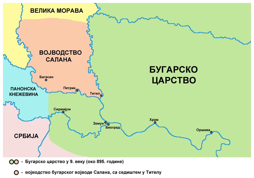
English: historical map of medieval duchy of Bulgarian duke Salan (9th century) - Serbian language version
Српски / srpski: историјска карта средњовековног војводства бугарског војводе Салана (9. век) - верзија на српском језику |
| Datum | 9. februar 2009. (првобитни датум слања) |
| Izvor | Sopstveno delo |
| Autor | PANONIAN |
References
Published references:
- Dr Aleksa Ivić, Istorija Srba u Vojvodini, Novi Sad, 1929.
- Radmilo Petrović, Vojvodina - petnaest milenijuma kulturne istorije, Beograd, 2003.
- Jovan Pejin, Velikomađarski kapric, Zrenjanin, 2007.
- Marko Jovanov, Devet vekova od pomena imena Titela, Titelski letopis, Titel, 2001.
- Istorijski atlas, Zavod za udžbenike i nastavna sredstva - Zavod za kartografiju "Geokarta", Beograd, 1999.
- Petrit Imami, Srbi i Albanci kroz vekove, Beograd, 2000.
Internet references:
Licenciranje
| Ja, tvorac ovog dela, predajem ga u javno vlasništvo. Ovo se odnosi na ceo svet. U nekim zemljama, ovo nije zakonski moguće; u tom slučaju: Ja, tvorac ovog dela dozvoljavam svakome da koristi ovo delo za bilo koju namenu, bez bilo kakvih uslova, osim uslova koje nameće zakon. |
Istorija datoteke
Kliknite na datum/vreme da biste videli tadašnju verziju datoteke.
| Datum/vreme | Minijatura | Dimenzije | Korisnik | Komentar | |
|---|---|---|---|---|---|
| trenutna | 22:12, 13. maj 2014. | | 1.018 × 713 (52 kB) | PANONIAN | aesthetics |
| 13:10, 5. mart 2011. |  | 1.020 × 713 (52 kB) | PANONIAN | aesthetical correction | |
| 09:24, 15. septembar 2009. |  | 1.020 × 713 (52 kB) | PANONIAN | Reverted to version as of 15:50, 29 July 2009 - fixing thumbnail problem | |
| 09:23, 15. septembar 2009. |  | 1.020 × 713 (52 kB) | PANONIAN | Reverted to version as of 15:50, 29 July 2009 - fixing thumbnail problem | |
| 09:23, 15. septembar 2009. |  | 542 × 474 (45 kB) | PANONIAN | Reverted to version as of 21:09, 20 June 2009 - fixing thumbnail problem | |
| 17:50, 29. jul 2009. |  | 1.020 × 713 (52 kB) | PANONIAN | ||
| 23:09, 20. jun 2009. |  | 542 × 474 (45 kB) | PANONIAN | since this is a duplicate of another file (File:Salan.png), I translated this one into Serbian language | |
| 01:07, 18. mart 2009. |  | 542 × 474 (39 kB) | PANONIAN | ||
| 01:45, 10. februar 2009. |  | 626 × 610 (50 kB) | PANONIAN | historical map of medieval duchy of duke Salan (self made) {{PD-self}} Category:Maps of the history of Vojvodina Category:Maps of the history of Serbia |
Upotreba datoteke
4 sledeće stranice koriste ovu datoteku:
Globalna upotreba datoteke
Drugi vikiji koji koriste ovu datoteku:
- Upotreba na mk.wikipedia.org