
Датотека:NEO lake jau big.jpg

Величина овог приказа: 600 × 600 пиксела. 3 друге резолуције: 240 × 240 пиксела | 480 × 480 пиксела | 750 × 750 пиксела.
Оригинална датотека (750 × 750 пиксела, величина датотеке: 134 kB, MIME тип: image/jpeg)
| Ово је датотека са Викимедијине оставе. Информације са њене странице са описом приказане су испод. Викимедијина остава је складиште слободно лиценциралних мултимедијалних датотека. И Ви можете да помогнете. |
Опис измене
| Опис |
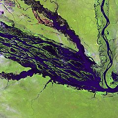
English: The Negro River flowing through the eastern edge of Brazil’s Jau National Park. The river is the big strip of blue running from left to right across the image, and the other blue ribbons are tributaries. Originating at the border of Venezuela and Brazil, the Negro River meets up with the Amazon in central Brazil to become its largest tributary. Half-submerged islands can be seen in the center of the river. Between November and April when the river is at its peak, many of these islands disappear. |
| Датум | |
| Извор |
http://earthobservatory.nasa.gov/Newsroom/NewImages/images.php3?img_id=10843
|
| Аутор | NASA and USGS EROS Data Center Satellite Systems Branch |
Лиценцирање
This image is in the public domain in the United States because it only contains materials that originally came from the United States Geological Survey, an agency of the United States Department of the Interior. For more information, see the official USGS copyright policy.
|
Првобитан дневник отпремања
Оригиналан опис странице је био овде. Сва наведена корисничка имена воде на en.wikipedia.
- 2003-11-23 05:55 Snoyes 750×750×8 (136760 bytes)
Историја датотеке
Кликните на датум/време да бисте видели тадашњу верзију датотеке.
| Датум/време | Минијатура | Димензије | Корисник | Коментар | |
|---|---|---|---|---|---|
| тренутна | 22:27, 4. април 2008. | | 750 × 750 (134 kB) | File Upload Bot (Magnus Manske) | {{BotMoveToCommons|en.wikipedia}} {{Information |Description={{en|'''Credit(s):''' [http://edc.usgs.gov/ USGS EROS Data Center] Satellite Systems Branch. '''Source:''' http://earthobservatory.nasa.gov/Newsroom/NewImages/images.php3?img_id=10843 ''?The |
Употреба датотеке
2 следеће странице користе ову датотеку:
Глобална употреба датотеке
Други викији који користе ову датотеку:
- Употреба на ar.wikipedia.org
- Употреба на ast.wikipedia.org
- Употреба на ba.wikipedia.org
- Употреба на be.wikipedia.org
- Употреба на bg.wikipedia.org
- Употреба на ca.wikipedia.org
- Употреба на de.wikipedia.org
- Употреба на de.wikivoyage.org
- Употреба на en.wikipedia.org
- Употреба на es.wikipedia.org
- Употреба на eu.wikipedia.org
- Употреба на fr.wikipedia.org
- Употреба на he.wikipedia.org
- Употреба на he.wikivoyage.org
- Употреба на hi.wikipedia.org
- Употреба на hr.wikipedia.org
- Употреба на id.wikipedia.org
- Употреба на it.wikivoyage.org
- Употреба на ja.wikipedia.org
- Употреба на ka.wikipedia.org
- Употреба на ko.wikipedia.org
- Употреба на lt.wikipedia.org
- Употреба на mai.wikipedia.org
- Употреба на ml.wikipedia.org
- Употреба на mt.wikipedia.org
- Употреба на ne.wikipedia.org
- Употреба на nl.wikipedia.org
- Употреба на pl.wikipedia.org
Још глобалног коришћења ове датотеке.