
Датотека:Nicobar Islands.jpg
Већа резолуција није доступна.
Nicobar_Islands.jpg (643 × 564 пиксела, величина датотеке: 70 kB, MIME тип: image/jpeg)
| Ово је датотека са Викимедијине оставе. Информације са њене странице са описом приказане су испод. Викимедијина остава је складиште слободно лиценциралних мултимедијалних датотека. И Ви можете да помогнете. |
Опис измене
| Опис |
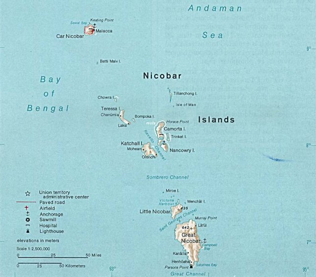
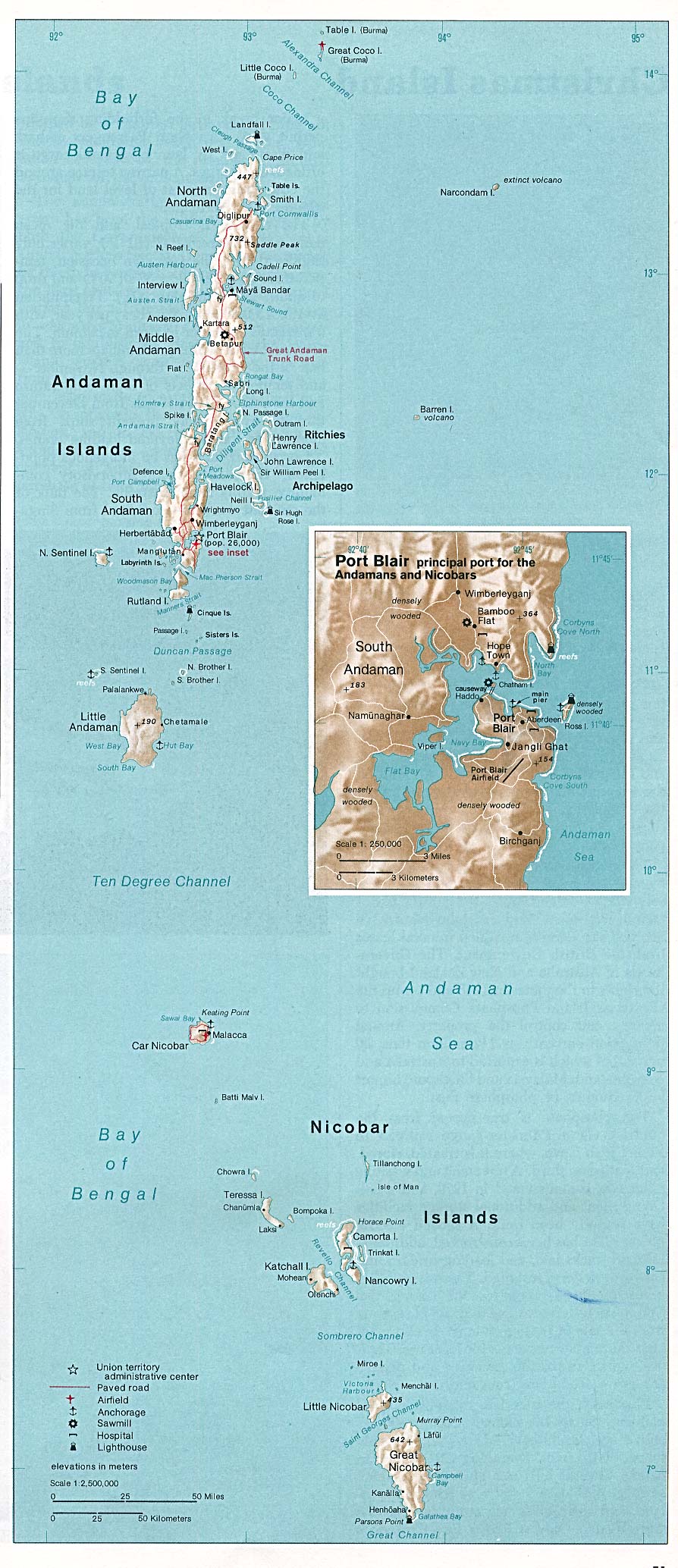
Deutsch: Karte der Inselgruppe der Nikobaren im Indischen Ozean
English: Map of the Nicobar Island in the Indian Ocean
Français : Carte d’îles Nicobar dans l’océan Indien |
| Датум | |
| Извор | http://www.lib.utexas.edu/maps/islands_oceans_poles/andaman_nicobar_76.jpg |
| Аутор | Taken from Perry-Castañeda Library (PCL), originally from CIA Indian Ocean Atlas |
| Остале верзије |
Лиценцирање
| This image is a work of a Central Intelligence Agency employee, taken or made as part of that person's official duties. As a Work of the United States Government, this image or media is in the public domain in the United States.
|

|
Историја датотеке
Кликните на датум/време да бисте видели тадашњу верзију датотеке.
| Датум/време | Минијатура | Димензије | Корисник | Коментар | |
|---|---|---|---|---|---|
| тренутна | 00:33, 15. мај 2005. | | 643 × 564 (70 kB) | Jeroen | From the Indian Ocean Atlas, published by the Central Intelligence Agency, 1976. From en:Image:Nicobar_Islands.jpg ''This image is a work of a Central Intelligence Agency employee, taken or made during the course of the person's official duties. As |
Употреба датотеке
Следећа страница користи ову датотеку:
Глобална употреба датотеке
Други викији који користе ову датотеку:
- Употреба на ace.wikipedia.org
- Употреба на ar.wikipedia.org
- Употреба на arz.wikipedia.org
- Употреба на az.wikipedia.org
- Употреба на be-tarask.wikipedia.org
- Употреба на bg.wikipedia.org
- Употреба на bn.wikipedia.org
- Употреба на br.wikipedia.org
- Употреба на ca.wikipedia.org
- Употреба на ceb.wikipedia.org
- Употреба на cs.wikipedia.org
- Употреба на da.wikipedia.org
- Употреба на de.wikipedia.org
- Употреба на en.wikipedia.org
- Употреба на eo.wikipedia.org
- Употреба на es.wikipedia.org
- Употреба на eu.wikipedia.org
- Употреба на fa.wikipedia.org
- Употреба на fi.wikipedia.org
- Употреба на fi.wiktionary.org
- Употреба на fr.wikipedia.org
- Употреба на fr.wikinews.org
- Употреба на gl.wikipedia.org
- Употреба на gu.wikipedia.org
- Употреба на hi.wikipedia.org
- Употреба на id.wikipedia.org
- Употреба на ilo.wikipedia.org
- Употреба на it.wikipedia.org
- Употреба на ja.wikipedia.org
- Употреба на ka.wikipedia.org
- Употреба на ko.wikipedia.org
Још глобалног коришћења ове датотеке.