
Датотека:Detailed map of Wakefield-Peacedale, Rhode Island.png
Већа резолуција није доступна.
Detailed_map_of_Wakefield-Peacedale,_Rhode_Island.png (575 × 425 пиксела, величина датотеке: 51 kB, MIME тип: image/png)
| Ово је датотека са Викимедијине оставе. Информације са њене странице са описом приказане су испод. Викимедијина остава је складиште слободно лиценциралних мултимедијалних датотека. И Ви можете да помогнете. |
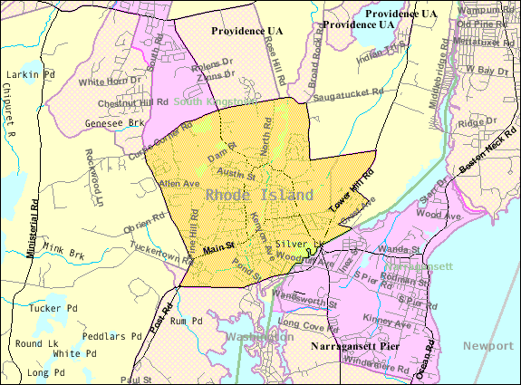
| Опис | Map of Wakefield-Peacedale, a census-designated place in the town of South Kingstown in Washington County, Rhode Island, United States, with its boundaries at the time of the 2000 census. | |||
| Датум | Непознат датум; downloaded by me on 29 December 2008 | |||
| Извор | http://factfinder.census.gov/leg1/44/123071444.gif, from http://factfinder.census.gov | |||
| Аутор | United States Census Bureau | |||
| Дозвола (Поновно коришћење ове датотеке) |
|

Историја датотеке
Кликните на датум/време да бисте видели тадашњу верзију датотеке.
| Датум/време | Минијатура | Димензије | Корисник | Коментар | |
|---|---|---|---|---|---|
| тренутна | 16:46, 29. децембар 2008. | | 575 × 425 (51 kB) | Nyttend | {{Information |Description=Map of {{w|Wakefield-Peacedale, Rhode Island|Wakefield-Peacedale}}, a {{w|census-designated place}} in the town of {{w|South Kingstown, Rhode Island|South Kingstown}} in {{w|Washington County, Rhode Island|Washington County}}, { |
Употреба датотеке
Следећа страница користи ову датотеку:
Глобална употреба датотеке
Други викији који користе ову датотеку:
- Употреба на ca.wikipedia.org
- Употреба на ceb.wikipedia.org
- Употреба на en.wikipedia.org
- Употреба на es.wikipedia.org
- Употреба на eu.wikipedia.org
- Употреба на fa.wikipedia.org
- Употреба на sh.wikipedia.org
- Употреба на tt.wikipedia.org
- Употреба на www.wikidata.org