
Датотека:Fukushima I nuclear accidents radioactive cloud-en.svg

Оригинална датотека (SVG датотека, номинално 511 × 183 пиксела, величина: 2,86 MB)
| Ово је датотека са Викимедијине оставе. Информације са њене странице са описом приказане су испод. Викимедијина остава је складиште слободно лиценциралних мултимедијалних датотека. И Ви можете да помогнете. |
Опис измене
| Опис |
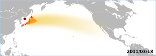
The Fukushima accident's radioactive plume. The map displays areas which have been overflown by the plume. Made by the Graphic Lab/Map workshop's wikigraphists (WP:GL/MAP) Sources 2011/03/18:
Note: Aeronobie.be now ask to cite and follow the Zamg.ac.at's page (currently the main source), stating: '--Varlaam 21:19, 24 March 2011 (UTC)'"The World Meteorological Organisation asked the Central Institute for Meteorology and Geodynamics (or ZAMG, Austria) to support the International Atomic Energy Agency by providing the atmospheric plume calculations." Background based on: A blank map of the world centred at the 180E longitude line. Detailed SVG map with grouping enabled to connect all non-contiguous parts of a country's territory for easy colouring. Smaller countries can also be represented by larger circles to show their data easier. A thorough description of use and other instructions relating to can be found on the instruction page |
||
| Датум | (UTC) | ||
| Извор | Own work based on: BlankMap-World-180E.svg | ||
| Аутор | BlankMap-World-180E.svg: Lokal_Profil / derivative work: Yug | ||
| SVG genesis |
|
Лиценцирање
| Ја, творац овог дела, предајем га у јавно власништво. Ово се односи на цео свет. У неким земљама, ово није законски могуће; у том случају: Ја, творац овог дела дозвољавам свакоме да користи ово дело за било коју намену, без било каквих услова, осим услова које намеће закон. |
Првобитан дневник отпремања
This image is a derivative work of the following images:
- File:BlankMap-World-180E.svg licensed with PD-self
- 2008-04-13T22:24:07Z Lokal_Profil 940x477 (3620359 Bytes) {{Information |Description=A blank map of the world centered at the 180E longitude line. Detailed SVG map with grouping enabled to connect all non-contiguous parts of a country's territory for easy colouring. Smaller count
Uploaded with derivativeFX
Историја датотеке
Кликните на датум/време да бисте видели тадашњу верзију датотеке.
| Датум/време | Минијатура | Димензије | Корисник | Коментар | |
|---|---|---|---|---|---|
| тренутна | 17:06, 18. март 2011. | 511 × 183 (2,86 MB) | Yug | reduction of the area, the source go forward USA-Mexico, but don't reach them by 03/20. | |
| 15:18, 18. март 2011. | 511 × 183 (2,86 MB) | Yug | fix famous "black square bug" ;) | ||
| 15:06, 18. март 2011. | 511 × 183 (2,86 MB) | Yug | {{Information |Description=Fukushima accident's radioactive cloud. Made by the Graphic Lab/Map workshop's wikigraphists ([[:en:WP:GL/MAP) Sources 2011/03/18: * {{cite web|title=Nouvelle simulation du |
Употреба датотеке
2 следеће странице користе ову датотеку:
Глобална употреба датотеке
Други викији који користе ову датотеку:
- Употреба на ca.wikipedia.org
- Употреба на de.wikipedia.org
- Употреба на de.wikinews.org
- Употреба на en.wikipedia.org
- Употреба на fr.wikipedia.org
- Употреба на sh.wikipedia.org
- Употреба на uk.wikipedia.org