
Датотека:Greece GHI Solar-resource-map GlobalSolarAtlas World-Bank-Esmap-Solargis.png

Оригинална датотека (1.842 × 2.063 пиксела, величина датотеке: 1,48 MB, MIME тип: image/png)
| Ово је датотека са Викимедијине оставе. Информације са њене странице са описом приказане су испод. Викимедијина остава је складиште слободно лиценциралних мултимедијалних датотека. И Ви можете да помогнете. |
Опис измене
| Опис |
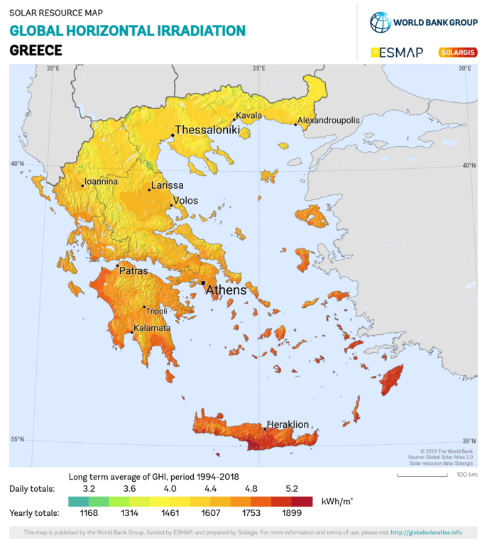
English: Solar resource: GLOBAL HORIZONTAL IRRADIATION (GHI) - this map provides a summary of the estimated solar energy available for power generation and other energy applications. It represents the long-term average of daily/yearly totals of global horizontal irradiation (GHI). The underlying solar resource database is calculated by the Solargis model from atmospheric and satellite data with 15- or 30-minute time step. The effects of terrain are considered at nominal spatial resolution of 250 m. GHI is the most important parameter for energy yield calculation and performance assessment of flat-plate photovoltaic (PV) technologies. Further details available at: https://globalsolaratlas.info. |
| Датум | |
| Извор | https://globalsolaratlas.info/downloads |
| Аутор | Solargis |
| Ауторство (required by the license) | © The World Bank, Source: Global Solar Atlas 2.0, Solar resource data: Solargis / |
The World Bank Group has published this solar resource map using data from the Global Solar Atlas (GSA), to support the scale-up of solar power in our client countries. This work is funded by the Energy Sector Management Assistance Program (ESMAP), a multi-donor trust fund administered by The World Bank and supported by 18 donor partners. It is part of a global ESMAP initiative on Renewable Energy Resource Mapping that covers biomass, hydropower, solar and wind. This map has been prepared by Solargis, under contract to The World Bank, based on a solar resource database that Solargis owns and maintains. To obtain additional maps and information, please visit: http://globalsolaratlas.info.
Лиценцирање
- Дозвољено је:
- да делите – да умножавате, расподељујете и преносите дело
- да прерађујете – да прерадите дело
- Под следећим условима:
- ауторство – Морате да дате одговарајуће заслуге, обезбедите везу ка лиценци и назначите да ли су измене направљене. Можете то урадити на било који разуман манир, али не на начин који предлаже да лиценцатор одобрава вас или ваше коришћење.
Историја датотеке
Кликните на датум/време да бисте видели тадашњу верзију датотеке.
| Датум/време | Минијатура | Димензије | Корисник | Коментар | |
|---|---|---|---|---|---|
| тренутна | 16:08, 27. јануар 2021. | | 1.842 × 2.063 (1,48 MB) | SolarSoft | Updated temporal coverage, recalculated data period. |
| 15:55, 31. мај 2011. |  | 800 × 869 (474 kB) | SolarSoft |
Употреба датотеке
Следећа страница користи ову датотеку:
Глобална употреба датотеке
Други викији који користе ову датотеку:
- Употреба на ar.wikipedia.org
- Употреба на az.wikipedia.org
- Употреба на el.wikipedia.org
- Употреба на en.wikipedia.org
- Употреба на es.wikipedia.org
- Употреба на fi.wikipedia.org
- Употреба на fr.wikipedia.org
- Употреба на it.wikipedia.org
- Употреба на ka.wikipedia.org
- Употреба на ru.wikipedia.org
- Употреба на sl.wikipedia.org
- Употреба на test2.wikipedia.org
- Употреба на te.wikipedia.org