
Датотека:Kingdom of Germany 1004.svg

Величина PNG прегледа за ову SVG датотеку је 485 × 340 пиксела. 5 других резолуција: 320 × 224 пиксела | 640 × 449 пиксела | 1.024 × 718 пиксела | 1.280 × 897 пиксела | 2.560 × 1.795 пиксела.
Оригинална датотека (SVG датотека, номинално 485 × 340 пиксела, величина: 1,23 MB)
| Ово је датотека са Викимедијине оставе. Информације са њене странице са описом приказане су испод. Викимедијина остава је складиште слободно лиценциралних мултимедијалних датотека. И Ви можете да помогнете. |
Опис измене
This W3C-unspecified vector image was created with Inkscape .


.svg)
.svg)
.svg)
.svg)
.svg)


.svg)
.svg)
.svg)


.png)
.png)


.svg)


.svg)

.svg)


.svg)
.svg)
.svg)
.svg)


.svg)
.png)


.svg)


.svg)
.svg)


.svg)


.svg)


.svg)
.svg)
.svg)
.svg)
.svg)
.svg)
.svg)
.svg)
_cropped.svg)
.svg)
.svg)
.svg)
.svg)
.svg)
.svg)
.svg)
.svg)
.svg)
.svg)
.svg)
.svg)
.svg)
.svg)
.svg)
.svg)
.svg)
.svg)
.svg)
.svg)
.svg)
.svg)
.svg)
.svg)
.svg)
.svg)
.svg)
.svg)
.svg)
.svg)
.svg)
.svg)
.svg)
.svg)
.svg)
.svg)
.svg)
.svg)
.svg)
.svg)
.svg)
.svg)
.svg)
.svg)
.svg)
Лиценцирање
Ова датотека је доступна под лиценцом Creative Commons Ауторство-Делити под истим условима 4.0 међународна.
- Дозвољено је:
- да делите – да умножавате, расподељујете и преносите дело
- да прерађујете – да прерадите дело
- Под следећим условима:
- ауторство – Морате да дате одговарајуће заслуге, обезбедите везу ка лиценци и назначите да ли су измене направљене. Можете то урадити на било који разуман манир, али не на начин који предлаже да лиценцатор одобрава вас или ваше коришћење.
- делити под истим условима – Ако измените, преобразите или доградите овај материјал, морате поделити своје доприносе под истом или компатибилном лиценцом као оригинал.
Историја датотеке
Кликните на датум/време да бисте видели тадашњу верзију датотеке.
| Датум/време | Минијатура | Димензије | Корисник | Коментар | |
|---|---|---|---|---|---|
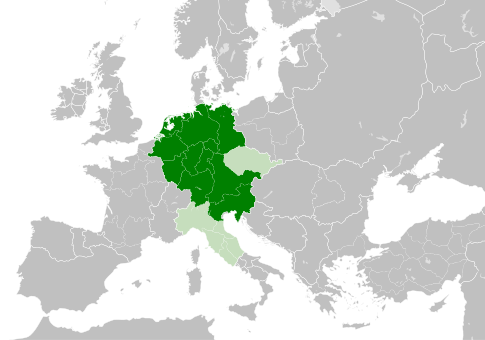
| тренутна | 13:49, 4. мај 2021. | | 485 × 340 (1,23 MB) | E-960 | Tribute was paid under Mieszko I, by the year 1000 Bolesław I the Brave stopped paying it |
| 15:14, 23. мај 2016. |  | 485 × 340 (1,23 MB) | Der Golem | Duchy of Bohemia was part of the Holy Roman Empire, but not within the Kingdom of Germany | |
| 22:19, 22. мај 2016. |  | 485 × 340 (1,23 MB) | Alphathon | == {{int:filedesc}} == {{Inkscape}} {{Information |Description={{en|A map of the Kingdom of Germany within the Holy Roman Empire and within Europe circa 1004 CE, after the incorporation of the [[:en:Duchy of Bohemia|Duchy of... |
Употреба датотеке
Нема страница које користе ову датотеку.
Глобална употреба датотеке
Други викији који користе ову датотеку:
- Употреба на az.wikipedia.org
- Употреба на ba.wikipedia.org
- Употреба на be.wikipedia.org
- Употреба на ca.wikipedia.org
- Употреба на cs.wikipedia.org
- Употреба на en.wikipedia.org
- Употреба на eo.wikipedia.org
- Употреба на es.wikipedia.org
- Употреба на et.wikipedia.org
- Употреба на eu.wikipedia.org
- Употреба на fr.wikipedia.org
- Употреба на id.wikipedia.org
- Употреба на ja.wikipedia.org
- Употреба на ko.wikipedia.org
- Употреба на la.wikipedia.org
- Употреба на lv.wikipedia.org
- Употреба на pl.wikipedia.org
- Употреба на ru.wikipedia.org
- Употреба на uk.wikipedia.org
- Употреба на www.wikidata.org
.svg)