
Датотека:MBTA Commuter Rail and funding district map.svg

Величина PNG прегледа за ову SVG датотеку је 800 × 489 пиксела. 6 других резолуција: 320 × 196 пиксела | 640 × 392 пиксела | 1.024 × 626 пиксела | 1.280 × 783 пиксела | 2.560 × 1.566 пиксела | 904 × 553 пиксела.
Оригинална датотека (SVG датотека, номинално 904 × 553 пиксела, величина: 2,37 MB)
| Ово је датотека са Викимедијине оставе. Информације са њене странице са описом приказане су испод. Викимедијина остава је складиште слободно лиценциралних мултимедијалних датотека. И Ви можете да помогнете. |
Опис измене
| Опис |
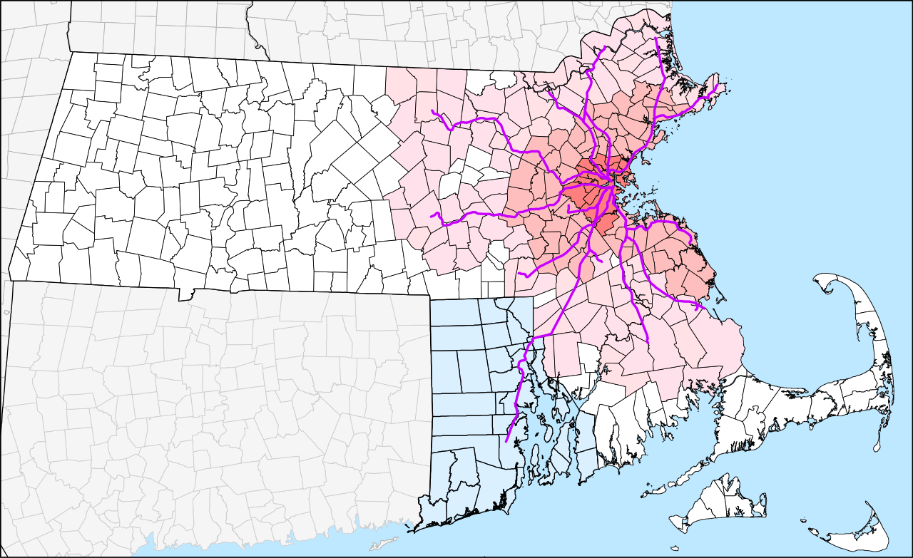
English: Geographic map of the MBTA Commuter Rail system and the MBTA funding district. The original 14-town MTA district is shown in darkest pink, the 78-town MBTA district established in 1964 in medium pink, and the 175-town "forward funding" district established in 1999 as light pink. White areas are not part of the MBTA district but still pay state sales taxes which are partially used to fund the MBTA.
Rhode Island, which is not part of the district but pays for service to 3 stations under the 1988 Pilgrim Partnership, is shown in light blue. |
| Датум | The map was originally uploaded on 29 March 2006. The latest version is accurate to the 23 April 2012 extension to Wickford Junction. |
| Извор |
Сопствено дело by User:Pi.1415926535 |
| Аутор |
User:Pi.1415926535 (version 2) SPUI (version 1) |
| Остале верзије |
Derivative works of this file: |
| SVG genesis |
Лиценцирање
| Ја, творац овог дела, предајем га у јавно власништво. Ово се односи на цео свет. У неким земљама, ово није законски могуће; у том случају: Ја, творац овог дела дозвољавам свакоме да користи ово дело за било коју намену, без било каквих услова, осим услова које намеће закон. |
Историја датотеке
Кликните на датум/време да бисте видели тадашњу верзију датотеке.
| Датум/време | Минијатура | Димензије | Корисник | Коментар | |
|---|---|---|---|---|---|
| тренутна | 22:46, 20. фебруар 2014. | | 904 × 553 (2,37 MB) | Pi.1415926535 | Slight zoom in |
| 22:30, 20. фебруар 2014. |  | 961 × 556 (2,51 MB) | Pi.1415926535 | Version 2.0.0: New version from all-new datasets. Town outlines from MassGIS, state outlines from USGS, and rail lines from article's KML file. Adjacent states have been added; some minor errors remain. | |
| 07:04, 3. август 2012. |  | 8.248 × 5.248 (4,97 MB) | Pi.1415926535 | Grouping etc. No visual changes to map. | |
| 06:53, 3. август 2012. |  | 8.248 × 5.248 (4,97 MB) | Pi.1415926535 | Adding Rhode Island map from File:Providence Metro Area.svg | |
| 05:08, 23. април 2012. |  | 8.248 × 5.248 (4,92 MB) | Pi.1415926535 | Wickford Junction opens tomorrow! | |
| 06:21, 13. јул 2011. |  | 8.248 × 5.248 (4,92 MB) | Pi.1415926535 | Updated with under-construction Wachusett and Wickford Junction extensions. Grouped segments into lines for easier modification. (See talk page). | |
| 01:39, 15. мај 2011. |  | 8.248 × 5.248 (4,9 MB) | Pi.1415926535 | T.F. Green Extension and Greenbush Line are now open since the creation of the map. Also added Wildcat (Wilmington) Branch between Lowell and Haverhill lines; it is used for some rush-hour trains. A few bits were ungrouped for ease of modification. | |
| 12:56, 29. март 2006. |  | 8.248 × 5.248 (4,84 MB) | SPUI~commonswiki | {{spuimap}} MBTA district. Old MTA district darkest, then original MBTA district, then 1999 expansion. Commuter Rail lines in purple, planned lines thinner and dashed. Data source: [http://www.mass.gov/mgis/download.htm Office of Geographic and Environme |
Употреба датотеке
Следећа страница користи ову датотеку:
Глобална употреба датотеке
Други викији који користе ову датотеку:
- Употреба на de.wikipedia.org
- Употреба на en.wikipedia.org
- Употреба на id.wikipedia.org
- Употреба на ko.wikipedia.org
- Употреба на simple.wikipedia.org
- Употреба на www.wikidata.org
- Употреба на zh-yue.wikipedia.org
- Употреба на zh.wikipedia.org