
Датотека:Central Tien Shan, China.JPG

Originalna datoteka (4.288 × 2.850 piksela, veličina datoteke: 1,92 MB, MIME tip: image/jpeg)
| Ovo je datoteka sa Vikimedijine ostave. Informacije sa njene stranice sa opisom prikazane su ispod. Vikimedijina ostava je skladište slobodno licenciralnih multimedijalnih datoteka. I Vi možete da pomognete. |
Opis izmene
| Opis |
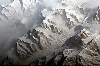
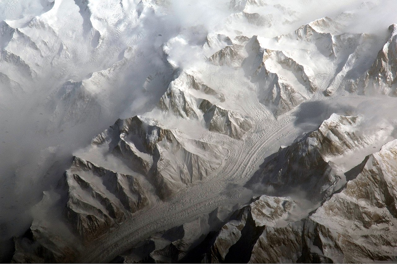
English: This astronaut photograph provides a view of the central Tien Shan, about 64 kilometres east of where the borders of China, Kyrgyzstan, and Kazakhstan meet.
While the image looks like it might have been taken from an airplane, it was taken from the International Space Station (ISS) at an altitude of 341 kilometres. The altitude plus the horizontal distance from the site—ISS was approximately 304 kilometres to the south-west—produces an oblique view. This angle, together with shadowing of valleys, accentuates the mountainous topography. Two types of glaciers are visible in the image; cirque glaciers occupy amphitheater-like depressions on the upper slopes of the mountains, and feed ice down-slope to aggregate into large valley glaciers such as the one at image centre. Low clouds obscure an adjacent valley and glaciers to the north (upper left). Two high peaks of the central Tien Shan are identifiable in the image. Xuelian Feng has a summit of 6, 527 meters above sea level. To the east, the aptly-named Peak 6231 has a summit 6,231 meters above sea level. |
| Datum | |
| Izvor | NASA Earth Observatory |
| Autor | ISS Expedition 27 crew |
| Положај камере | | Ова и друге слике снимљене у близини на: OpenStreetMap |
|---|
This image or video was catalogued by Johnson Space Center of the United States National Aeronautics and Space Administration (NASA) under Photo ID: ISS027-E-5274. This tag does not indicate the copyright status of the attached work. A normal copyright tag is still required. See Commons:Licensing. Other languages:
|
Image acquired with a Nikon D2Xs digital camera using an 800 mm lens, and is provided by the ISS Crew Earth Observations experiment and Image Science & Analysis Laboratory, Johnson Space Center.
Licenciranje
| Ова датотека је у јавном власништву зато што је њен аутор НАСА. НАСА-а политика ауторских права наводи „Материјали НАСА-е нису заштићени ауторским правима осим ако није другачије наведено“. (Погледајте Template:PD-USGov, NASA copyright policy page или JPL Image Use Policy.) | ||
 |
Упозорења:
|
| Annotations | This image is annotated: View the annotations at Commons |
Istorija datoteke
Kliknite na datum/vreme da biste videli tadašnju verziju datoteke.
| Datum/vreme | Minijatura | Dimenzije | Korisnik | Komentar | |
|---|---|---|---|---|---|
| trenutna | 12:58, 28. mart 2011. | | 4.288 × 2.850 (1,92 MB) | Originalwana | {{Information |Description ={{en|1=This astronaut photograph provides a view of the central Tien Shan, about 64 kilometres east of where the borders of China, Kyrgyzstan, and Kazakhstan meet. While the image looks like it might have been taken |
Upotreba datoteke
Sledeća stranica koristi ovu datoteku:
Globalna upotreba datoteke
Drugi vikiji koji koriste ovu datoteku:
- Upotreba na ast.wikipedia.org
- Upotreba na cs.wikipedia.org
- Upotreba na de.wikipedia.org
- Upotreba na es.wikipedia.org
- Upotreba na fi.wikipedia.org
- Upotreba na gl.wikipedia.org
- Upotreba na he.wikipedia.org
- Upotreba na hr.wikipedia.org
- Upotreba na ml.wikipedia.org
- Upotreba na mr.wikipedia.org
- Upotreba na ug.wikipedia.org
- Upotreba na uk.wikipedia.org
- Upotreba na www.wikidata.org