
Датотека:Iles glorieuses 76.jpg

Veličina ovog prikaza: 800 × 491 piksela. 3 druge rezolucije: 320 × 196 piksela | 640 × 393 piksela | 896 × 550 piksela.
Originalna datoteka (896 × 550 piksela, veličina datoteke: 102 kB, MIME tip: image/jpeg)
| Ovo je datoteka sa Vikimedijine ostave. Informacije sa njene stranice sa opisom prikazane su ispod. Vikimedijina ostava je skladište slobodno licenciralnih multimedijalnih datoteka. I Vi možete da pomognete. |
Opis izmene
| Opis |
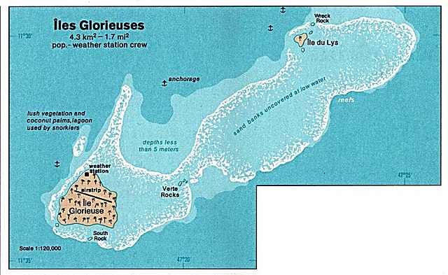
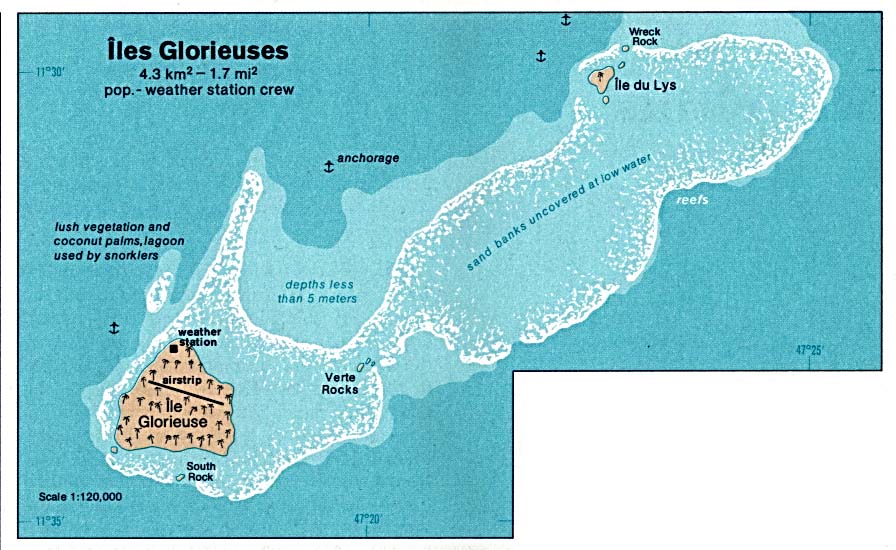
Deutsch: Karte der Îles Glorieuses im Indischen Ozean
English: Map of Glorioso Island in the Indian Ocean
Français : Carte d’îles Glorieuses dans l’océan Indien |
| Datum | |
| Izvor | http://www.lib.utexas.edu/maps/islands_oceans_poles/iles_glorieuses_76.jpg |
| Autor | Taken from Perry-Castañeda Library (PCL), originally from CIA Indian Ocean Atlas |
| Dozvola (Ponovno korišćenje ove datoteke) |
PD, see licensing |
Licenciranje
| This image is a work of a Central Intelligence Agency employee, taken or made as part of that person's official duties. As a Work of the United States Government, this image or media is in the public domain in the United States.
|

|
Istorija datoteke
Kliknite na datum/vreme da biste videli tadašnju verziju datoteke.
| Datum/vreme | Minijatura | Dimenzije | Korisnik | Komentar | |
|---|---|---|---|---|---|
| trenutna | 07:36, 3. februar 2005. | | 896 × 550 (102 kB) | Dysprosia~commonswiki | {{PD-PCL|http://www.lib.utexas.edu/maps/islands_oceans_poles/iles_glorieuses_76.jpg}} |
Upotreba datoteke
Sledeća stranica koristi ovu datoteku:
Globalna upotreba datoteke
Drugi vikiji koji koriste ovu datoteku:
- Upotreba na ar.wikipedia.org
- Upotreba na az.wikipedia.org
- Upotreba na be.wikipedia.org
- Upotreba na cs.wikipedia.org
- Upotreba na el.wikipedia.org
- Upotreba na en.wikipedia.org
- Upotreba na eo.wikipedia.org
- Upotreba na es.wikipedia.org
- Upotreba na fa.wikipedia.org
- Upotreba na fr.wikipedia.org
- Upotreba na gl.wikipedia.org
- Upotreba na hi.wikipedia.org
- Upotreba na hr.wikipedia.org
- Upotreba na hu.wikipedia.org
- Upotreba na id.wikipedia.org
- Upotreba na ja.wikipedia.org
- Upotreba na ka.wikipedia.org
- Upotreba na lij.wikipedia.org
- Upotreba na mk.wikipedia.org
- Upotreba na nl.wikipedia.org
- Upotreba na no.wikipedia.org
- Upotreba na pl.wikipedia.org
- Upotreba na ru.wikipedia.org
- Upotreba na sh.wikipedia.org
- Upotreba na sv.wikipedia.org
- Upotreba na uk.wikipedia.org
- Upotreba na ur.wikipedia.org
- Upotreba na vi.wikipedia.org
- Upotreba na zh.wikipedia.org