
Датотека:MPK1-426 Sykes Picot Agreement Map signed 8 May 1916.jpg
Originalna datoteka (3.322 × 3.225 piksela, veličina datoteke: 5,7 MB, MIME tip: image/jpeg)
| Ovo je datoteka sa Vikimedijine ostave. Informacije sa njene stranice sa opisom prikazane su ispod. Vikimedijina ostava je skladište slobodno licenciralnih multimedijalnih datoteka. I Vi možete da pomognete. |
Opis izmene
| Opis |
العربية: خريطة اتفاقية سايكس بيكو تُظهر شرق تُركيا في آسيا وسوريا وغرب بلاد فارس ومناطق نفوذ البريطانيين والفرنسيين المُتَّفق عليها. الجمعية الجغرافية الملكية، 15-1910. وقعها مارك سايكس و فرانسوا جورج بيكو، 8 مايو 1916.
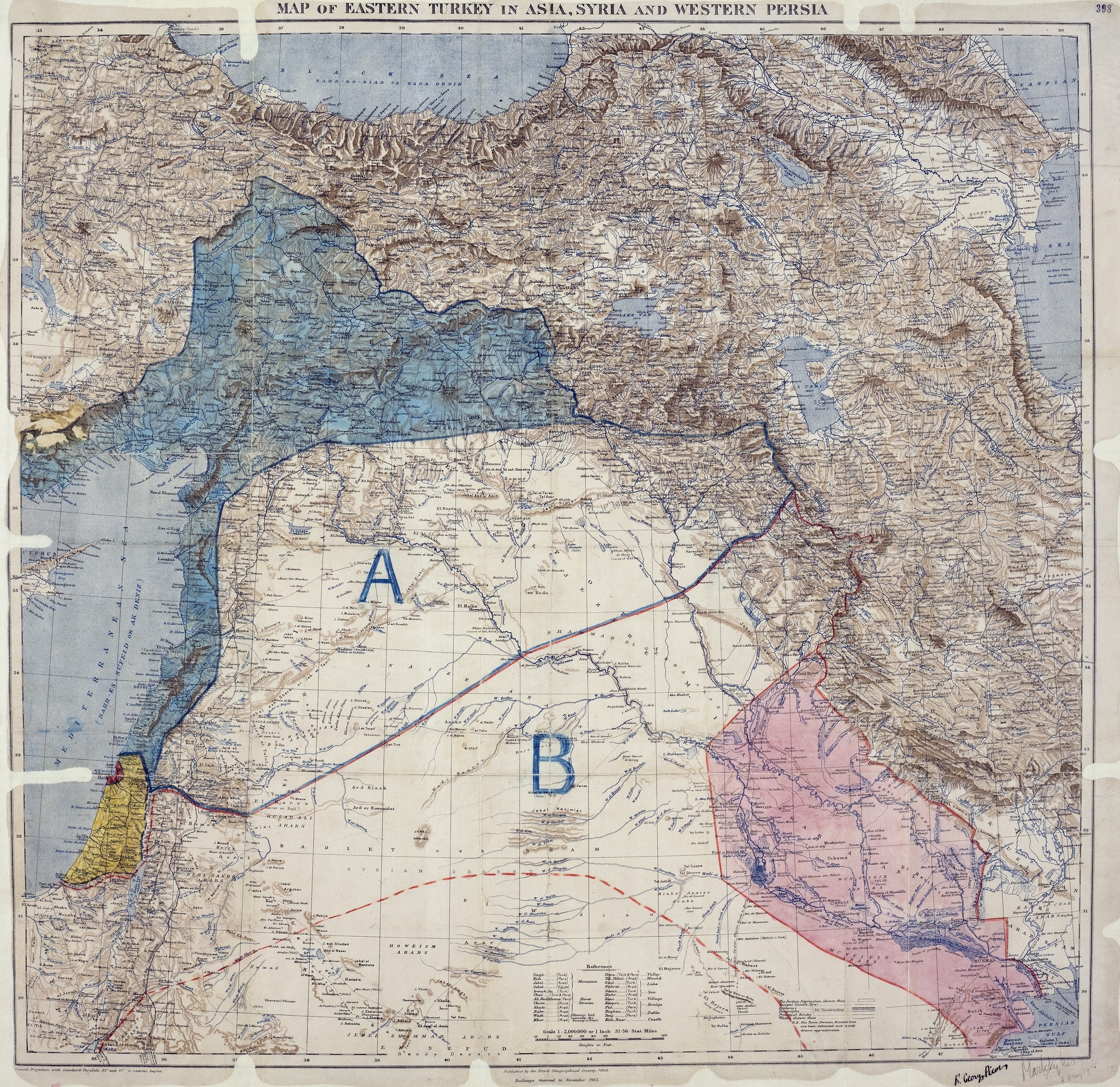
English: Map of showing Eastern Turkey in Asia, Syria and Western Persia, and areas of control and influence agreed between the British and the French. Royal Geographical Society, 1910-15. Signed by Mark Sykes and François Georges-Picot, 8 May 1916.
Français : Carte des Accords Sykes-Picot montrant la Turquie orientale en Asie, Syrie et Perse occidentale, ainsi que les zones de contrôle et d'influence convenues entre la France et le Royaume-Uni. Royal Geographical Society, 1910-15. Signés par Mark Sykes et François Georges-Picot, le 8 Mai 1916.
Kurdî: Nexşeya Peymana Sykes–Picot li Asyayê, rojhilatê Tirkiyeyê, Sûrî û rojavayê Îranê û herêmên di bin serwerî û bandora Brîtanya û Fransa de nîşan dide. Ji aliyê Royal Geographical Society ve, 1910-15 hatiye çêkirin. Ji aliyê Mark Sykes û François Georges-Picot ve hatiye îmzekirin, 8 gulan 1916
Português: Mapa do Acordo Sykes-Picot mostrando a Turquia Oriental na Ásia, a Síria e Pérsia Ocidental e áreas de controle e influência definidas pelos britânicos e os franceses. Real Sociedade Geográfica, 1910-15. Assinado por Mark Sykes e François Georges-Picot, 8 de maio de 1916.
Türkçe: Sykes-Picot Anlaşması kapsamında Fransız ve İngiliz etkisi ve kontrol alanları, Türkiye'nin doğusunda Suriye ve Batı İran bir harita gösterilmektedir.Kraliyet Coğrafya Kurumu, 1910-15. Mark Sykes ve François Georges-Picot imzaları, 8 Mayıs 1916. |
||
| Datum | |||
| Izvor |
|
||
| Tvorac | |||
| Georeferencing | If inappropriate please set warp_status = skip to hide. | ||
| Ostale verzije |
_on_8_May_1916_-_(cropped).jpg)
_on_8_May_1916_(cropped).jpg)
|
Licenciranje
Овај рад је у јавном власништву у Сједињеним Државама зато што је објављен или регистрован у канцеларији за ауторска права САД-а пре 1. јануара 1929.
Овај рад мора бити у јавном власништву у Сједињеним Државама и држави порекла да би се хостовао на Остави. Ако рад није дело америчког аутора, датотека обавезно мора имати и ознаку ауторских права за државу порекла да би се знало зашто је овај рад у јавном власништву у држави порекла.
|
This work created by the United Kingdom Government is in the public domain.
This is because it is one of the following:
HMSO has declared that the expiry of Crown Copyrights applies worldwide (ref: HMSO Email Reply)
|
 |
Istorija datoteke
Kliknite na datum/vreme da biste videli tadašnju verziju datoteke.
| Datum/vreme | Minijatura | Dimenzije | Korisnik | Komentar | |
|---|---|---|---|---|---|
| trenutna | 05:58, 16. maj 2017. | | 3.322 × 3.225 (5,7 MB) | PawełMM | Cropped 8 % horizontally and 2 % vertically using CropTool with lossless mode. |
| 09:01, 12. oktobar 2011. |  | 3.600 × 3.293 (5,9 MB) | Gavin.collins |
Upotreba datoteke
Sledeća stranica koristi ovu datoteku:
Globalna upotreba datoteke
Drugi vikiji koji koriste ovu datoteku:
- Upotreba na ar.wikipedia.org
- وعد بلفور
- مراسلات الحسين – مكماهون
- اتفاقية سايكس بيكو
- بوابة:محتوى متميز
- ويكيبيديا:صور مختارة
- ويكيبيديا:صور مختارة/رسومات وجداول وخرائط
- بوابة:الوطن العربي/صورة مختارة/أرشيف
- ويكيبيديا:صور مختارة/رسومات وجداول وخرائط/خرائط
- بوابة:محتوى متميز/محتويات
- بوابة:محتوى متميز/محتويات/صور مختارة
- بوابة:محتوى متميز/الرئيسية
- الانتداب البريطاني على فلسطين (صك قانوني)
- احتلال معان
- التسوية الإنجليزية الفرنسية المؤقتة 1918
- ويكيبيديا:ترشيحات الصور المختارة/خريطة اتفاقية سايكس بيكو
- ويكيبيديا:صورة اليوم المختارة/أكتوبر 2023
- قالب:صورة اليوم المختارة/2023-10-29
- بوابة:الوطن العربي/صورة مختارة/143
- Upotreba na arz.wikipedia.org
- Upotreba na ast.wikipedia.org
- Upotreba na az.wikipedia.org
- Upotreba na bn.wikipedia.org
- Upotreba na ca.wikipedia.org
- Upotreba na ckb.wikipedia.org
- Upotreba na cy.wikipedia.org
- Upotreba na de.wikipedia.org
- Upotreba na el.wikipedia.org
- Upotreba na en.wikipedia.org
- Arabs
- Balfour Declaration
- Emirate of Transjordan
- Sykes–Picot Agreement
- Great Syrian Revolt
- Grease pencil
- Golan Heights
- Mandate for Palestine
- User:Chickstarr404/Gather lists/14627 – Personal History - Desert Gardens by Vincent Sheehan
- Wikipedia:Graphics Lab/Photography workshop/Archive/Jun 2017
- 1918 Anglo-French Modus Vivendi
- Occupation of Ma'an
- User:Free Syrian 200/الثورة السورية الكبرى
- User:Lou Löwe/sandbox
- Rashid Rida during World War I
- User:Sarah SchneiderCH/sandbox2
- User:Falcaorib/Israel and Palestine
- Upotreba na eo.wikipedia.org
- Upotreba na es.wikipedia.org
- Upotreba na fa.wikipedia.org
- Upotreba na fi.wikipedia.org
Još globalnog korišćenja ove datoteke.