
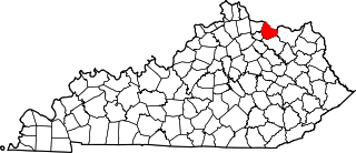
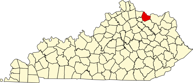
Датотека:Map of Kentucky highlighting Mason County.svg

Veličina PNG pregleda za ovu SVG datoteku je 800 × 345 piksela. 6 drugih rezolucija: 320 × 138 piksela | 640 × 276 piksela | 1.024 × 441 piksela | 1.280 × 551 piksela | 2.560 × 1.103 piksela | 6.770 × 2.916 piksela.
Originalna datoteka (SVG datoteka, nominalno 6.770 × 2.916 piksela, veličina: 127 kB)
| Ovo je datoteka sa Vikimedijine ostave. Informacije sa njene stranice sa opisom prikazane su ispod. Vikimedijina ostava je skladište slobodno licenciralnih multimedijalnih datoteka. I Vi možete da pomognete. |
Opis izmene
| Opis |
English: This is a locator map showing Mason County in Kentucky. For more information, see Commons:United States county locator maps. |
| Datum | |
| Izvor |
Sopstveno delo: English: The maps use data from nationalatlas.gov, specifically countyp020.tar.gz on the Raw Data Download page. The maps also use state outline data from statesp020.tar.gz. The Florida maps use hydrogm020.tar.gz to display Lake Okeechobee. |
| Autor | David Benbennick |
Licenciranje
| Ja, tvorac ovog dela, predajem ga u javno vlasništvo. Ovo se odnosi na ceo svet. U nekim zemljama, ovo nije zakonski moguće; u tom slučaju: Ja, tvorac ovog dela dozvoljavam svakome da koristi ovo delo za bilo koju namenu, bez bilo kakvih uslova, osim uslova koje nameće zakon. |
Istorija datoteke
Kliknite na datum/vreme da biste videli tadašnju verziju datoteke.
| Datum/vreme | Minijatura | Dimenzije | Korisnik | Komentar | |
|---|---|---|---|---|---|
| trenutna | 14:23, 12. februar 2006. | | 6.770 × 2.916 (127 kB) | David Benbennick | {{subst:User:Dbenbenn/clm|county=Mason County|state=Kentucky}} |
Upotreba datoteke
Sledeća stranica koristi ovu datoteku:
Globalna upotreba datoteke
Drugi vikiji koji koriste ovu datoteku:
- Upotreba na ar.wikipedia.org
- Upotreba na azb.wikipedia.org
- Upotreba na bg.wikipedia.org
- Upotreba na bpy.wikipedia.org
- Upotreba na cdo.wikipedia.org
- Upotreba na ceb.wikipedia.org
- Upotreba na ce.wikipedia.org
- Upotreba na ckb.wikipedia.org
- Upotreba na cs.wikipedia.org
- Upotreba na cy.wikipedia.org
- Upotreba na de.wikipedia.org
- Upotreba na en.wikipedia.org
- Mason County, Kentucky
- Dover, Kentucky
- Maysville, Kentucky
- Sardis, Kentucky
- Germantown, Kentucky
- List of counties in Kentucky
- Template:Mason County, Kentucky
- User:Nyttend/County templates/KY/2
- Shannon, Kentucky
- National Register of Historic Places listings in Mason County, Kentucky
- Fox Farm site (Mays Lick, Kentucky)
- Mays Lick, Kentucky
- Category:Populated places in Mason County, Kentucky
- Template:MasonCountyKY-geo-stub
- Minerva, Kentucky
- Orangeburg, Kentucky
- Fernleaf, Kentucky
- Helena, Kentucky
- Weedonia, Kentucky
- Somo, Kentucky
- Lawrence Creek (Kentucky)
- Upotreba na es.wikipedia.org
- Upotreba na et.wikipedia.org
- Upotreba na eu.wikipedia.org
- Upotreba na fa.wikipedia.org
- Upotreba na fa.wikivoyage.org
- Upotreba na frr.wikipedia.org
Još globalnog korišćenja ove datoteke.