Датотека:Nile River and delta from orbit.jpg

Sadržaj stranice nije podržan na drugim jezicima
Ovo je datoteka sa Vikimedijine ostave
S Vikipedije, slobodne enciklopedije

Nile_River_and_delta_from_orbit.jpg(700 × 550 piksela, veličina datoteke: 85 kB, MIME tip: image/jpeg)

Opis izmene

Opis

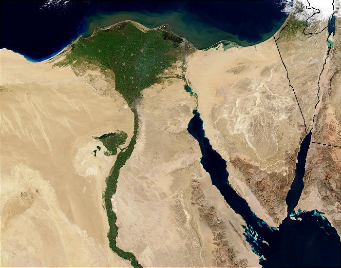
Nile River and delta from orbit Description: The Nile River and delta as seen from space by the MODIS sensor on the Terra satellite.

"Against the barren desert of northeastern Africa, the fertile valley of the Nile River runs northward through Egypt. In the higher-resolution images, the city of Cairo can be seen as a gray smudge right where the river widens into its broad fan-shaped delta. Other cities are dotted across the green landscape, giving it a speckled appearance. Where the Nile empties into the Mediterranean Sea (top) the waters are swirling with color, likely a mixture of sediment, organic matter, and possibly marine plant life. Farther west, the bright blue color of the water is likely less-organically rich sediment, perhaps sand.
"East of the delta lies the arid Sinai Peninsula, whose pointed tip is home to rugged mountains, some as high as 8,600 feet. The lattice work of pale lines marks the paths of ephemeral rivers. The Sinai Peninsula intrudes into the Red Sea. Farther east are Israel, Jordan, and Saudi Arabia. At top right is the disputed territory of the West Bank.
"In the false-color image, vegetation is bright green, water is dark blue or black, and clouds are light blue. It's interesting to notice that places that seem essentially arid, or desert-like in the true-color image in fact have a delicate layer of vegetation. For example, the central Sinai Peninsula, and most of Israel have a faint greenish tinge in the false-color images.
Datum
Izvor http://visibleearth.nasa.gov/view_rec.php?id=4927 [1]
Autor Jacques Descloitres, MODIS Rapid Response Team, NASA/sh
Ostale verzije Cuaggjacgacugvajgca

Salchicha

Licenciranje

Public domain Ова датотека је у јавном власништву зато што је њен аутор НАСА. НАСА-а политика ауторских права наводи „Материјали НАСА-е нису заштићени ауторским правима осим ако није другачије наведено“. (Погледајте Template:PD-USGov, NASA copyright policy page или JPL Image Use Policy.)
Упозорења:
  • Употреба НАСА-их логотипа и емблема је ограничена Америчким законом 14 CFR 1221.
  • НАСА-ин сајт хостује велики број слика Совјетске/Руске свемирске агенције и других не-Америчких свемирских агенција. Ове слике нису нужно у јавном власништву.
  • Материјали засновани на подацима Хабл телескопа су слободни само ако је њихов аутор STScI.[2] Такође погледајте {{PD-Hubble}} и {{Cc-Hubble}}.
  • Материјали са сонде SOHO су заштићени ауторским правима и потребна је дозвола за комерцијалну употребу. [3]
  • Слике са сајта APOD можда подлежу ауторским правима. [4]

Natpisi

Dodajte objašnjenje u jednom redu o tome šta ova datoteka predstavlja
Nile delta

Stavke prikazane u ovoj datoteci

prikazuje

5. februar 2003

Istorija datoteke

Kliknite na datum/vreme da biste videli tadašnju verziju datoteke.

Datum/vremeMinijaturaDimenzijeKorisnikKomentar
trenutna00:47, 30. novembar 2004.Minijatura za verziju na dan 00:47, 30. novembar 2004.700 × 550 (85 kB)MschlindweinNile River and delta from orbit

Sledeća stranica koristi ovu datoteku:

Globalna upotreba datoteke

Drugi vikiji koji koriste ovu datoteku:

Još globalnog korišćenja ove datoteke.