
Датотека:Whitefish Bay, Door County, Wisconsin 2020.png

Veličina ovog prikaza: 440 × 599 piksela. 6 drugih rezolucija: 176 × 240 piksela | 353 × 480 piksela | 564 × 768 piksela | 752 × 1.024 piksela | 1.505 × 2.048 piksela | 9.321 × 12.687 piksela.
Originalna datoteka (9.321 × 12.687 piksela, veličina datoteke: 216,34 MB, MIME tip: image/png)
| Ovo je datoteka sa Vikimedijine ostave. Informacije sa njene stranice sa opisom prikazane su ispod. Vikimedijina ostava je skladište slobodno licenciralnih multimedijalnih datoteka. I Vi možete da pomognete. |
| Warning | The original file is very high-resolution. It might not load properly or could cause your browser to freeze when opened at full size. |
|---|
| Opis |
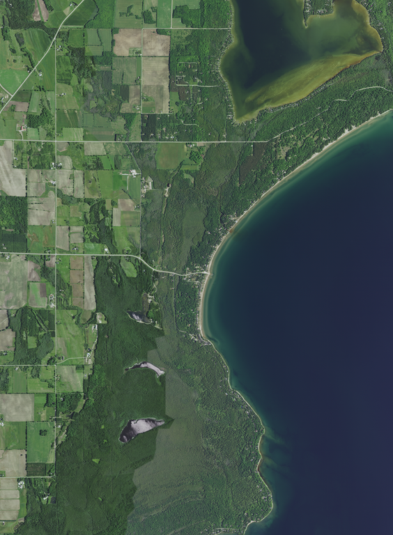
English: The unincorporated community of Whitefish Bay and vicinity in the town of Sevastopol, Door County, Wisconsin, Wisconsin, taken June 27, 2020. Interior lakes or seasonally inundated areas pictured, from north to south: Clark Lake, Lake of the Woods, Arbter Lake, and Schwartz Lake. Recreational areas pictured in whole or in part include Whitefish Dunes State Park (top, long exterior shore), Logan Creek State Natural Area far right hand corner, three town of Sevastopol parks: Town Line Boat Launch into Clark Lake (west of lake), Clark Lake Beach (south of lake), and the Whitefish Bay Boat Launch into Lake Michigan (center), Cave Point County Park (top right), the Places We Protect: Shivering Sands preserve (lower center) and the Cave Point-Clay Banks Shivering Sands Unit State Natural Area Map 559b (lower center). Wisconsin Rustic Road 9 follows near much of the shore area of of the photograph.
|
|||
| Datum | ||||
| Izvor | converted to .png by Epiphyllumlover from the original .tif available as item M_4408707_SW_16_060_20200627 on EarthExplorer | |||
| Autor | Aerial Photography Field Office (APFO) for NAIP, USGS; in contract with the Surdex Corporation | |||
| Dozvola (Ponovno korišćenje ove datoteke) |
|
|||
| Ostale verzije |
.png)
.png)
.png)
.png)
.png)
Istorija datoteke
Kliknite na datum/vreme da biste videli tadašnju verziju datoteke.
| Datum/vreme | Minijatura | Dimenzije | Korisnik | Komentar | |
|---|---|---|---|---|---|
| trenutna | 08:42, 11. decembar 2021. | | 9.321 × 12.687 (216,34 MB) | Epiphyllumlover | c:User:Rillke/bigChunkedUpload.js: {{Information | Description = {{en|Whitefish Bay in Door County, Wisconsin, taken June 27, 2020. *Center Latitude 44°54'23.41"N *Center Longitude 87°13'06.66"W *NW Corner Lat 44°56'26.49"N *NW Corner Long 87°15'14.72"W *NE Corner Lat 44°56'26.98"N *NE Corner Long 87°10'59.54"W *SE Corner Lat 44°52'20.29"N *SE Corner Long 87°10'58.75"W *SW Corner Lat 44°52'19.80"N *SW Corner Long 87°15'13.64"W}} | Date... |
Upotreba datoteke
Nema stranica koje koriste ovu datoteku.