Датотека:1755 Bellin Map of the Great Lakes - Geographicus - GreatLakes-bellin-1755.jpg
Садржај странице није подржан на другим језицима
Ово је датотека са Викимедијине оставе
С Википедије, слободне енциклопедије

Оригинална датотека(4.000 × 3.215 пиксела, величина датотеке: 3,49 MB, MIME тип: image/jpeg)

Jacques-Nicolas Bellin: Partie Occidentale de la Nouvelle France ou du Canada.   (Wikidata search (Cirrus search) Wikidata query (SPARQL)  Create new Wikidata item based on this file)
Уметник
Jacques-Nicolas Bellin  (1703–1772)  wikidata:Q607846 s:fr:Auteur:Jacques-Nicolas Bellin
 
Друга имена
Jacques Nicolas, Sieur Bellin; Jacques Nicolas Bellin; Nicolas Bellin
Опис француски картограф, Француски енциклопедисти, географ и хидрограф
Датум рођења/смрти 1703 Уреди на Википодацима 21. март 1772. Уреди на Википодацима
Место рођења/смрти Париз Версај
Нормативна контрола
artist QS:P170,Q607846
Наслов
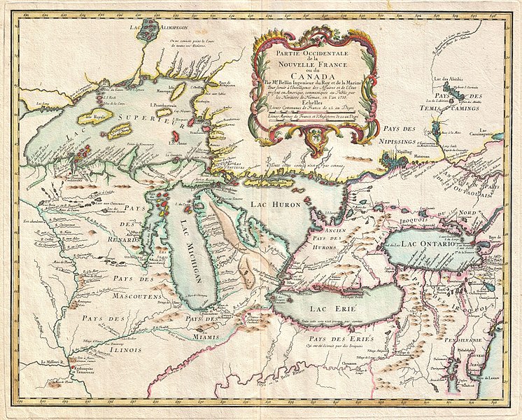
Partie Occidentale de la Nouvelle France ou du Canada.
Опис
English: A rare and extremely influential 1755 map of the Great Lakes drawn by Jacques Nicolas Bellin. This map, which appeared in the 1755 issue of the Homann Heirs Atlas Major, covers all five of the Great Lakes as well as the adjacent Indian lands and the English colonies of Pennsylvania, New Jersey and New York. Cartographically this map offers a number of important innovations and is largely derived from Bellin’s very similar map of 1745. The plate was acquired and reissued by Homann Heirs in 1755 in response to European interest in the French and Indian War which started one year prior in 1754. Bellin based this map on the most advanced French cartographic intelligence available at the time. Heidenrich and Dahl consider this map to constitute “the first new material pertaining to New France to appear since the maps of Guillaume de L'Isle three decades earlier. Most notably this map incorporates the work of the French fur trader and explorer Sieur la Verendrye and the explorer-missionary Father Pierre de Charlevoix. From Verendrye, Bellin is able to extract a significantly advanced view, over De L’Isle, of the form of the Great Lakes and their client river systems. He also relies on Verendrye’s journals with regard to the placement of numerous Indian nations and villages. Charlevoix is generally regarded as Bellin’s source for his curious choice to include several fictional islands in Lake Superior, including I. Philippeaux, I. Pontchartrain, and I. St. Anne. This map is the first, though hardly the last, to depict these ghost islands which baffled explorers until the early 19th century. A quick overview of this map will reveal a territory that is very much dominated by various American Indian nations though nominally under a tenuous French hegemony. The vast lands of the Miami, the Iroquois, the Erie, the Huron, the Renard, the Mascouten, and the Illinois overwhelm tiny bastions of French power in the form of various forts and missions. Among these are Fort Frontenac, Fort Niagara, Mission Francois Xavier, and the fledgling “R. et Port de Checagou,” the future site of Chicago. The French, without the vast colonial resources of the English and Spanish, relied heavily on alliance with, rather than outright control of, indigenous populations. Thus it is understandable why the American Indian nations of this region were quick to throw their lot in with the French against the domineering English during the French and Indian War. In the lower right hand quadrants of this map Bellin employs a common cartographic trick to flatter his royal patrons in Paris. By diminishing the proportional size of the English colonial holdings in Pennsylvania, New Jersey, Virginia and New York, Bellin, at least metaphorically, advances the supremacy of the French dominions in North America. In addition to its advanced mapping of the Great Lakes, its introduction of the ghost islands of Lake Superior, and its incorporation of the most recent explorations in the region, this map enjoys lasting significance due to John Mitchell’s use of it in compiling his important wall map, A Map of the British & French Dominions in North America. Mitchell’s monumental cartographic masterpiece was used in 1783 to define the boundaries between Canada and the post-Revolutionary United States, forming the basis for national borders that are still in effect today.
Датум 1755 (dated)
Димензије висина: 17,5 in (44,4 cm); ширина: 21,5 in (54,6 cm)
dimensions QS:P2048,17.5U218593
dimensions QS:P2049,21.5U218593
Пописни број
Geographicus link: GreatLakes-bellin-1755
Извор/фотограф

Atlas Homannianus Mathematic-Historice Delineatus, (Homann Heirs, Nuremberg), 1755.

Дозвола
(Поновно коришћење ове датотеке)
Ова слика је верна дигитализација оригиналног дводимензионалног уметничког дела. Ово уметничко дело је у јавном власништву из следећих разлога:
Public domain

Овај рад је такође у јавном власништву у државама са роком ауторства за живота аутора плус 100 година или мање.


Морате такође ставити ознаку за јавно власништво у Сједињеним Државама да би се знало зашто је овај рад у јавном власништву у Сједињеним Државамa.
Званичан став Задужбине Викимедије је да „верне дигитализације дводимензионалних уметничких дела која су у јавном власништву, су такође у јавном власништву”.
Стога су фотографске репродукције у јавном власништву у Сједињеним Државама. Имајте на уму да зависно од државе у којој живите поновно коришћење овог садржаја можда забрањено или ограничено. За више информација погледајте Commons:Reuse of PD-Art photographs.

Натписи

Укратко шта ова датотека представља/приказује

Ставке приказане у овој датотеци

приказује

77e3e62eb9d4211797932f8b002ed36d64c800a7

3.215 пиксел

4.000 пиксел

Историја датотеке

Кликните на датум/време да бисте видели тадашњу верзију датотеке.

Датум/времеМинијатураДимензијеКорисникКоментар
тренутна01:49, 25. март 2011.Минијатура за верзију на дан 01:49, 25. март 2011.4.000 × 3.215 (3,49 MB)BotMultichillT{{subst:User:Multichill/Geographicus |link=http://www.geographicus.com/P/AntiqueMap/GreatLakes-bellin-1755 |product_name=1755 Bellin Map of the Great Lakes |map_title=Partie Occidentale de la Nouvelle France ou du Canada. |description=A rare and extremely

Следећа страница користи ову датотеку:

Глобална употреба датотеке

Други викији који користе ову датотеку: