
Датотека:Crookston Commercial Historic District.jpg

Величина овог приказа: 757 × 599 пиксела. 3 друге резолуције: 303 × 240 пиксела | 606 × 480 пиксела | 956 × 757 пиксела.
Оригинална датотека (956 × 757 пиксела, величина датотеке: 84 kB, MIME тип: image/jpeg)
| Ово је датотека са Викимедијине оставе. Информације са њене странице са описом приказане су испод. Викимедијина остава је складиште слободно лиценциралних мултимедијалних датотека. И Ви можете да помогнете. |
|
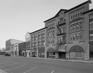
This is an image of a place or building that is listed on the National Register of Historic Places in the United States of America. Its reference number is 84002709. |
| Опис |
English: Buildings in the Crookston Commercial Historic District in central Crookston, Polk County, Minnesota, United States. The district reflects the city's early period of growth, which was prompted by agriculture and the railroad industry. It remains a large, and mostly intact, concentration of late nineteenth- and early twentieth-century commercial structures and is listed on the National Register of Historic Places. |
|||||
| Датум | Непознат датум | |||||
| Извор | Library of Congress Prints and Photographs Division, Historic American Buildings Survey: MINN,60-CROK,1-6 | |||||
| Аутор | Anonymous | |||||
| Дозвола (Поновно коришћење ове датотеке) |
|

| Положај објекта | | Ова и друге слике снимљене у близини на: OpenStreetMap |
|---|

|
This image is available from the United States Library of Congress's Prints and Photographs division
under the digital ID hhh.mn0444. This tag does not indicate the copyright status of the attached work. A normal copyright tag is still required. See Commons:Licensing.
|
Историја датотеке
Кликните на датум/време да бисте видели тадашњу верзију датотеке.
| Датум/време | Минијатура | Димензије | Корисник | Коментар | |
|---|---|---|---|---|---|
| тренутна | 16:07, 31. јануар 2009. | | 956 × 757 (84 kB) | Cropbot | upload cropped version, operated by User:Finavon. Summary: border cropped |
| 16:35, 29. јануар 2009. |  | 1.024 × 818 (96 kB) | Nyttend | {{Information |Description=Photograph from the {{w|Historic American Buildings Survey}} of buildings in the {{w|Crookston Commercial Historic District}}, an area listed on the {{w|National Register of Historic Places}}. The district is located in central |
Употреба датотеке
Следећа страница користи ову датотеку:
Глобална употреба датотеке
Други викији који користе ову датотеку:
- Употреба на ar.wikipedia.org
- Употреба на arz.wikipedia.org
- Употреба на azb.wikipedia.org
- Употреба на be.wikipedia.org
- Употреба на ca.wikipedia.org
- Употреба на ceb.wikipedia.org
- Употреба на ce.wikipedia.org
- Употреба на dag.wikipedia.org
- Употреба на de.wikipedia.org
- Употреба на en.wikipedia.org
- Употреба на en.wikivoyage.org
- Употреба на es.wikipedia.org
- Употреба на eu.wikipedia.org
- Употреба на fa.wikipedia.org
- Употреба на fr.wikipedia.org
- Употреба на ht.wikipedia.org
- Употреба на hu.wikipedia.org
- Употреба на ia.wikipedia.org
- Употреба на ko.wikipedia.org
- Употреба на ky.wikipedia.org
- Употреба на lld.wikipedia.org
- Употреба на pt.wikipedia.org
- Употреба на ru.wikipedia.org
- Употреба на sh.wikipedia.org
- Употреба на tr.wikipedia.org
- Употреба на tt.wikipedia.org
- Употреба на uk.wikipedia.org
- Употреба на ur.wikipedia.org
- Употреба на uz.wikipedia.org
- Употреба на vi.wikipedia.org
- Употреба на www.wikidata.org
- Употреба на zh-min-nan.wikipedia.org