
Датотека:Cuban crisis map missile range.jpg
Величина овог приказа: 603 × 599 пиксела. 3 друге резолуције: 241 × 240 пиксела | 483 × 480 пиксела | 666 × 662 пиксела.
Оригинална датотека (666 × 662 пиксела, величина датотеке: 198 kB, MIME тип: image/jpeg)
| Ово је датотека са Викимедијине оставе. Информације са њене странице са описом приказане су испод. Викимедијина остава је складиште слободно лиценциралних мултимедијалних датотека. И Ви можете да помогнете. |

|
Ова датотека је замењена датотеком File:The relative ranges of the IL-28, SS-4, and SS-5, stationed on Cuba.png. Препоручује се да искористите ту датотеку. Разлог: A PNG version of this file is now available.
|

|
| Опис |
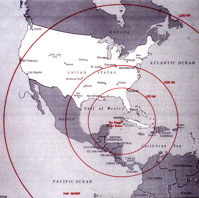
English: Map of Northern America showing the full range of the nuclear missiles under construction in Cuba, used during the secret meetings on the Cuban crisis. Deutsch: Diese Karte der westlichen Hemisphäre zeigt die volle Reichweite der Atomraketen, die auf Kuba im Rahmen der Kubakrise stationiert werden sollten bzw. worden sind. Diese Karte wurde bei den geheimen Treffen während der Kubakrise verwendet. Die Karte war ehemals Top Secret. Die eingezeichneten Radien sind in Nautischen Meilen (1 NM ~ 1,852 km) bemaßt; die 1020 NM (~ 1900 km) entsprechen ungefähr der taktischen Reichweite der SS-4, die 2200 NM (~ 4000 km) jener der SS-5. |
|||
| Датум | ||||
| Извор | The John F. Kennedy Presidential Library and Museum, Boston. [1] | |||
| Аутор | CIA | |||
| Дозвола (Поновно коришћење ове датотеке) |
|

![[1]](http://www.jfklibrary.org/jfkl/cmc/cmc_map_missile_range.jpg)
Историја датотеке
Кликните на датум/време да бисте видели тадашњу верзију датотеке.
| Датум/време | Минијатура | Димензије | Корисник | Коментар | |
|---|---|---|---|---|---|
| тренутна | 23:18, 8. јануар 2009. | | 666 × 662 (198 kB) | PaulBommel | {{Information |Description= |Source= |Date= |Author= |Permission= |other_versions= }} |
| 18:31, 9. јун 2007. |  | 700 × 920 (249 kB) | Nickel Chromo~commonswiki | {{Information| |Description= '''English''': Map of the western hemisphere showing the full range of the nuclear missiles under construction in Cuba, used during the secret meetings on the Cuban crisis. |Source= The John F. Kennedy Presidential Library and |
Употреба датотеке
2 следеће странице користе ову датотеку:
Глобална употреба датотеке
Други викији који користе ову датотеку:
- Употреба на ar.wikipedia.org
- Употреба на ba.wikipedia.org
- Употреба на bg.wikipedia.org
- Употреба на da.wikipedia.org
- Употреба на en.wikipedia.org
- Употреба на en.wikiquote.org
- Употреба на eo.wikipedia.org
- Употреба на es.wikipedia.org
- Употреба на fi.wikipedia.org
- Употреба на fi.wikibooks.org
- Употреба на ga.wikipedia.org
- Употреба на hr.wikipedia.org
- Употреба на it.wikipedia.org
- Употреба на lv.wikipedia.org
- Употреба на no.wikibooks.org
- Употреба на rm.wikipedia.org
- Употреба на ro.wikipedia.org
- Употреба на ru.wikipedia.org
- Употреба на sv.wikipedia.org
- Употреба на th.wikipedia.org
- Употреба на uk.wikipedia.org