
Датотека:ISS-39 Galveston Island.jpg

Величина овог приказа: 800 × 532 пиксела. 6 других резолуција: 320 × 213 пиксела | 640 × 426 пиксела | 1.024 × 681 пиксела | 1.280 × 852 пиксела | 2.560 × 1.703 пиксела | 4.256 × 2.832 пиксела.
Оригинална датотека (4.256 × 2.832 пиксела, величина датотеке: 2,78 MB, MIME тип: image/jpeg)
| Ово је датотека са Викимедијине оставе. Информације са њене странице са описом приказане су испод. Викимедијина остава је складиште слободно лиценциралних мултимедијалних датотека. И Ви можете да помогнете. |
Опис измене
| Опис |
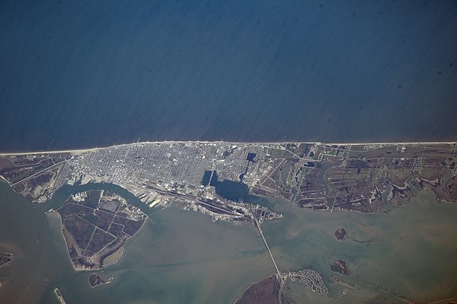
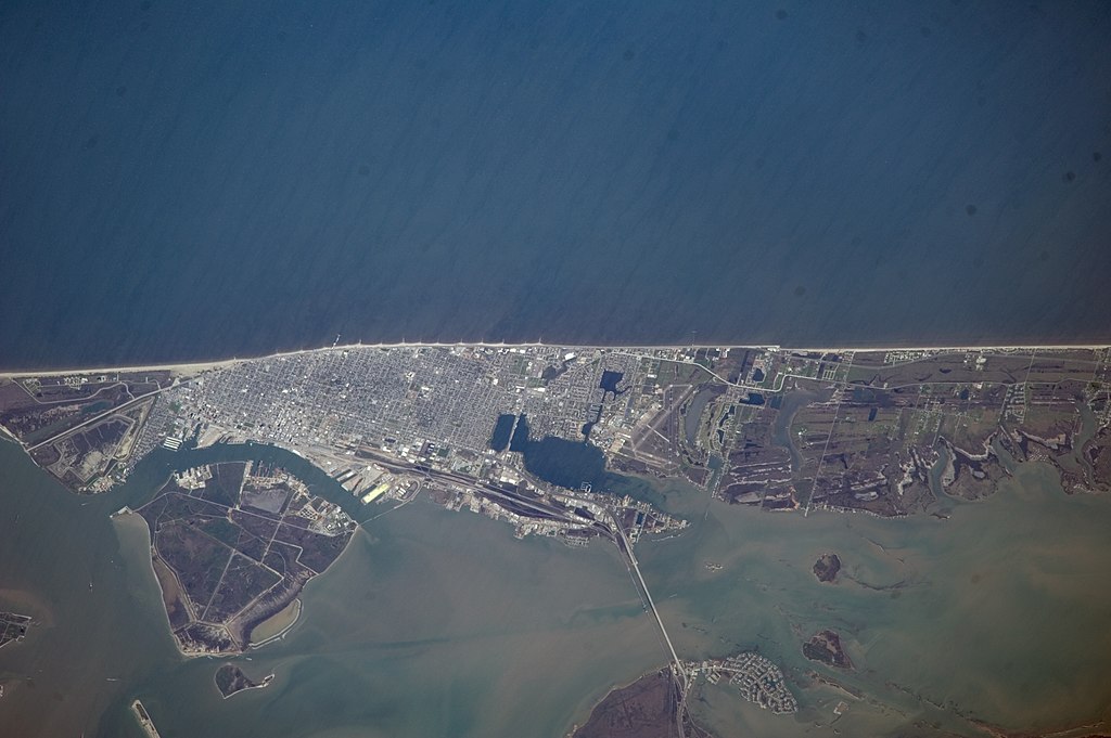
English: This nadir picture of Galveston Island and its coastline on the Gulf of Mexico was taken by one of the Expedition 39 crew members aboard the International Space Station on March 12.
|
| Датум | |
| Извор | https://www.flickr.com/photos/nasa2explore/13134466323/ |
| Аутор | NASA |
This image or video was catalogued by Johnson Space Center of the United States National Aeronautics and Space Administration (NASA) under Photo ID: ISS039-E-000707. This tag does not indicate the copyright status of the attached work. A normal copyright tag is still required. See Commons:Licensing. Other languages:
|
Лиценцирање
This file is in the public domain in the United States because it was created by the Image Science & Analysis Laboratory, of the NASA Johnson Space Center. NASA copyright policy states that "NASA material is not protected by copyright unless noted". (NASA media use guidelines or Conditions of Use of Astronaut Photographs).
Photo source: ISS039-E-000707.
|
Историја датотеке
Кликните на датум/време да бисте видели тадашњу верзију датотеке.
| Датум/време | Минијатура | Димензије | Корисник | Коментар | |
|---|---|---|---|---|---|
| тренутна | 23:50, 29. јун 2014. | | 4.256 × 2.832 (2,78 MB) | Ras67 | high quality rendering from NASA' raw data |
| 18:05, 27. јун 2014. |  | 4.256 × 2.832 (820 kB) | Ras67 | == {{int:filedesc}} == {{Information |Description={{en|1=This nadir picture of Galveston Island and its coastline on the Gulf of Mexico was taken by one of the Expedition 39 crew members aboard the International Space Station on March 12. It was among... |
Употреба датотеке
Следећа страница користи ову датотеку:
Глобална употреба датотеке
Други викији који користе ову датотеку:
- Употреба на arz.wikipedia.org
- Употреба на be.wikipedia.org
- Употреба на ceb.wikipedia.org
- Употреба на es.wikipedia.org
- Употреба на et.wikipedia.org
- Употреба на eu.wikipedia.org
- Употреба на fi.wikipedia.org
- Употреба на it.wikipedia.org
- Употреба на ru.wikipedia.org
- Употреба на www.wikidata.org