
Датотека:India-Pakistan Borderlands at Night.JPG
Величина овог приказа: 800 × 532 пиксела. 6 других резолуција: 320 × 213 пиксела | 640 × 426 пиксела | 1.024 × 681 пиксела | 1.280 × 852 пиксела | 2.560 × 1.703 пиксела | 4.256 × 2.832 пиксела.
Оригинална датотека (4.256 × 2.832 пиксела, величина датотеке: 3,11 MB, MIME тип: image/jpeg)
| Ово је датотека са Викимедијине оставе. Информације са њене странице са описом приказане су испод. Викимедијина остава је складиште слободно лиценциралних мултимедијалних датотека. И Ви можете да помогнете. |
Опис измене
| Опис |
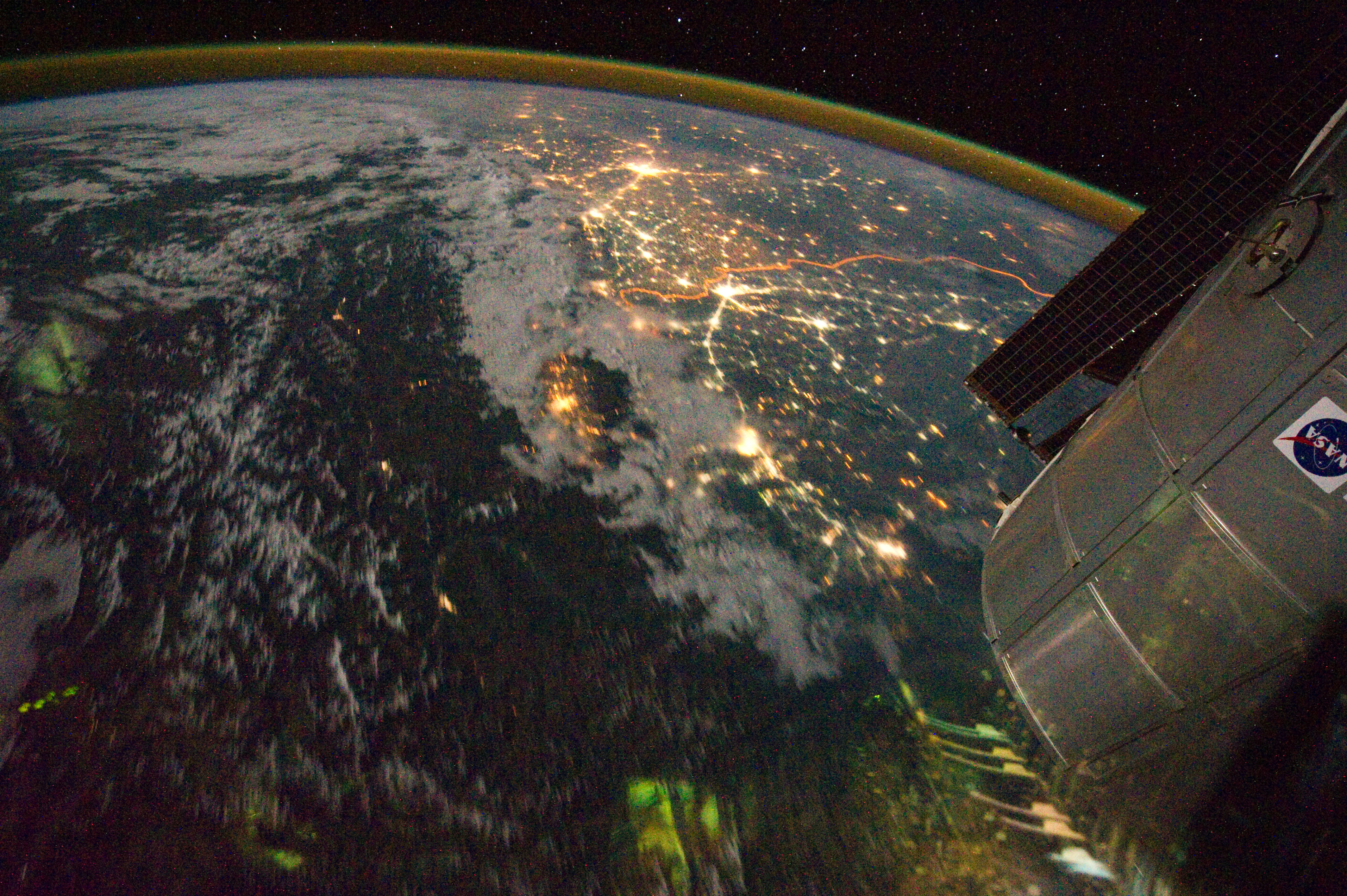
English: Clusters of yellow lights on the Indo-Gangetic Plain reveal numerous cities large and small in this astronaut photograph of northern India and northern Pakistan.
|
| Датум | |
| Извор | NASA Earth Observatory |
| Аутор | ISS Expedition 28 crew |
| Положај камере | | Ова и друге слике снимљене у близини на: OpenStreetMap |
|---|
This image or video was catalogued by Johnson Space Center of the United States National Aeronautics and Space Administration (NASA) under Photo ID: ISS028-E-29679. This tag does not indicate the copyright status of the attached work. A normal copyright tag is still required. See Commons:Licensing. Other languages:
|
Image acquired with a Nikon D3S digital camera using a 16 mm lens, and is provided by the ISS Crew Earth Observations experiment and Image Science & Analysis Laboratory, Johnson Space Center.
Лиценцирање
| Ова датотека је у јавном власништву зато што је њен аутор НАСА. НАСА-а политика ауторских права наводи „Материјали НАСА-е нису заштићени ауторским правима осим ако није другачије наведено“. (Погледајте Template:PD-USGov, NASA copyright policy page или JPL Image Use Policy.) | ||
 |
Упозорења:
|
| Annotations | This image is annotated: View the annotations at Commons |
Историја датотеке
Кликните на датум/време да бисте видели тадашњу верзију датотеке.
| Датум/време | Минијатура | Димензије | Корисник | Коментар | |
|---|---|---|---|---|---|
| тренутна | 17:03, 6. септембар 2011. | | 4.256 × 2.832 (3,11 MB) | Originalwana | {{Information |Description ={{en|1=Clusters of yellow lights on the Indo-Gangetic Plain reveal numerous cities large and small in this astronaut photograph of northern India and northern Pakistan. Of the hundreds of clusters, t |
Употреба датотеке
Следећа страница користи ову датотеку:
Глобална употреба датотеке
Други викији који користе ову датотеку:
- Употреба на ar.wikipedia.org
- Употреба на bh.wikipedia.org
- Употреба на bn.wikipedia.org
- Употреба на ca.wikipedia.org
- Употреба на en.wikipedia.org
- Употреба на hi.wikipedia.org
- Употреба на sl.wikipedia.org
- Употреба на ta.wikipedia.org
- Употреба на te.wikipedia.org
- Употреба на uk.wikipedia.org
- Употреба на vi.wikipedia.org