
Датотека:Kingdom of Hungary counties-2.svg

Величина PNG прегледа за ову SVG датотеку је 779 × 513 пиксела. 5 других резолуција: 320 × 211 пиксела | 640 × 421 пиксела | 1.024 × 674 пиксела | 1.280 × 843 пиксела | 2.560 × 1.686 пиксела.
Оригинална датотека (SVG датотека, номинално 779 × 513 пиксела, величина: 265 kB)
| Ово је датотека са Викимедијине оставе. Информације са њене странице са описом приказане су испод. Викимедијина остава је складиште слободно лиценциралних мултимедијалних датотека. И Ви можете да помогнете. |
| Опис |
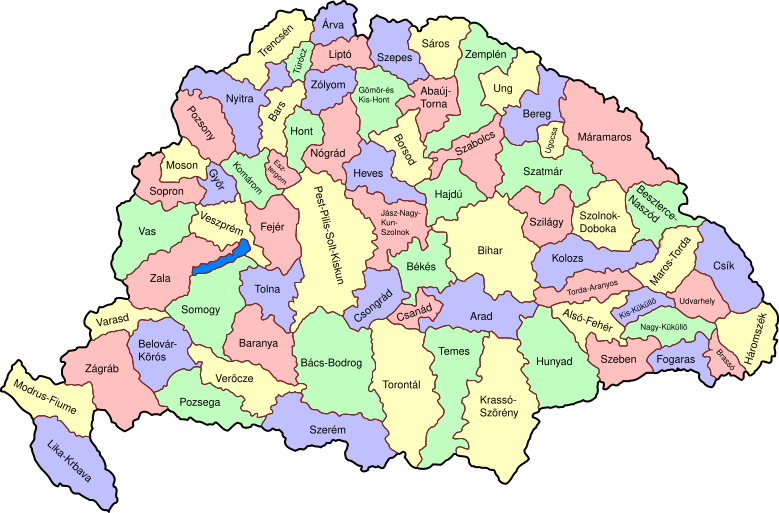
Map of counties of Kingdom of Hungary (Hungary proper and Croatia & Slavonia), 1886-1918. I have organised this into layers: Three layers of paths for the counties, for the county borders, and for external border. and one layer for the text labels. I have added basic styles and classified all elements. I have given all elements reasonable IDs the counties (the county name) and the borders (the names of the counties on each side) and the text labels (the names of the counties, with underscores indicating where they are split across labels). The counties are classed into four styles to make a four colour map, of course the colours can be changed just by changing the style (there as a fifth style for Lake Balaton, which does not show up very well on tis uploaded one). The main thing now is to fix the text styles. |
||
| Датум | (UTC) | ||
| Извор | |||
| Аутор |
|
||
| Остале верзије |
|

| Ово је ретуширана слика, што значи да је дигитално измењена у односу на своју изворну верзију. Измене: As described - added more useful metadata and structure. Изворна верзија се може видети овде: Kingdom of Hungary counties.svg. Измене је направио: SimonTrew.
|
Ја, носилац ауторског права над овим делом, објављујем исто под следећом лиценцом:
| Ја, творац овог дела, предајем га у јавно власништво. Ово се односи на цео свет. У неким земљама, ово није законски могуће; у том случају: Ја, творац овог дела дозвољавам свакоме да користи ово дело за било коју намену, без било каквих услова, осим услова које намеће закон. |
Првобитан дневник отпремања
This image is a derivative work of the following images:
- File:Kingdom_of_Hungary_counties.svg licensed with PD-self
- 2007-08-20T20:25:30Z Xavax 779x513 (240591 Bytes) == Summary == {{Information| |Description= Map of counties of Hungary with Croatia & Slavonia, 1886-1918 |Source=own drawing |Date=April 30, 2006 |Author=[[User:IMeowbot]] |Permission= |other_versions= }} == Licensing == {{P
- 2006-04-30T22:10:47Z IMeowbot 779x513 (228524 Bytes) line weight
- 2006-04-30T21:34:49Z IMeowbot 779x513 (225942 Bytes)
- 2006-04-30T18:34:30Z IMeowbot 779x513 (199213 Bytes) {{Information| |Description= Map of late 1870s Hungary counties |Source=own drawing |Date=April 30, 2006 |Author=[[User:IMeowbot]] |Permission= |other_versions= }}
Uploaded with derivativeFX
Историја датотеке
Кликните на датум/време да бисте видели тадашњу верзију датотеке.
| Датум/време | Минијатура | Димензије | Корисник | Коментар | |
|---|---|---|---|---|---|
| тренутна | 19:57, 5. децембар 2009. | | 779 × 513 (265 kB) | SimonTrew | I missed some fixes of Veszprém |
| 19:55, 5. децембар 2009. |  | 779 × 513 (265 kB) | SimonTrew | Fix spelling of Vesprém, as I have just done on original. | |
| 16:29, 3. децембар 2009. |  | 779 × 513 (265 kB) | SimonTrew | Fix spelling of Pozsony, as I have just done on original work | |
| 15:37, 3. децембар 2009. |  | 779 × 513 (265 kB) | SimonTrew | Made four colour map. The text still only uses one style at the moment, this needs to be made to match the four styles used for the four colours for the counties, but this is easier to do once it is uploaded and I can print the png. Sorry if this is "not | |
| 13:29, 3. децембар 2009. |  | 779 × 513 (287 kB) | SimonTrew | Fixed the few errors in borders, removed unnecessary style fields from text (Inkscape adds them but they are covered by other fields), text still needs doing better | |
| 03:16, 3. децембар 2009. |  | 779 × 513 (286 kB) | SimonTrew | {{Information |Description=Map of counties of Kingdom of Hungary (Hungary proper and Croatia & Slavonia), 1886-1918. I have organised this into layers: Three layers of paths for the counties, for the county borders, and for external border. and one layer |
Употреба датотеке
Следећа страница користи ову датотеку:
Глобална употреба датотеке
Други викији који користе ову датотеку:
- Употреба на ar.wikipedia.org
- Употреба на bs.wikipedia.org
- Употреба на ceb.wikipedia.org
- Употреба на ckb.wikipedia.org
- Употреба на da.wikipedia.org
- Употреба на de.wikipedia.org
- Употреба на en.wikipedia.org
- User talk:Random user 8384993
- Wikipedia talk:WikiProject Hungary/Archive 2
- Module:Location map/data/Kingdom of Hungary/doc
- Wikipedia:Redirects for discussion/Log/2015 April 19
- User:Drkazmer/Jewish centres in the Kingdom of Hungary
- Wikipedia:Graphics Lab/Map workshop/Archive/2017/Sep 2017
- Module:Location map/data/Kingdom of Hungary
- Употреба на fa.wikipedia.org
- Употреба на fr.wikipedia.org
- Употреба на hu.wikipedia.org
- Употреба на kn.wikipedia.org
- Употреба на pt.wikipedia.org
- Употреба на rue.wikipedia.org
- Употреба на si.wikipedia.org
- Употреба на tg.wikipedia.org
- Употреба на tr.wikipedia.org
- Употреба на uz.wikipedia.org
- Употреба на war.wikipedia.org