
Датотека:Languages of CE Europe-3.PNG
Величина овог приказа: 524 × 599 пиксела. 3 друге резолуције: 210 × 240 пиксела | 419 × 480 пиксела | 951 × 1.088 пиксела.
Оригинална датотека (951 × 1.088 пиксела, величина датотеке: 769 kB, MIME тип: image/png)
| Ово је датотека са Викимедијине оставе. Информације са њене странице са описом приказане су испод. Викимедијина остава је складиште слободно лиценциралних мултимедијалних датотека. И Ви можете да помогнете. |
Опис измене
| Опис |
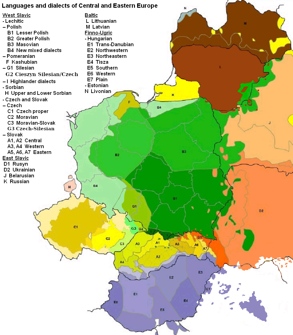
English: Map of languages and dialects of Central and Eastern Europe
Polski: Języki i dialekty Europy Srodkowo-Wschodniej
Deutsch: Legende:
|
||
| Датум | |||
| Извор |
Сопствено дело |
||
| Аутор | |||
| Остале верзије |
|

|
Ова linguistic map слика требало би да буду поново израђене као векторска графика у SVG формату. Тиме се остварује неколико предности. Више информација потражите на Commons:Media for cleanup. Ако је ова слика већ доступна у SVG формату, отпремите је. Након отпремања датотеке, овај шаблон замените шаблоном {{vector version available|new image name.svg}}.
|
Лиценцирање

|
Дата је дозвола да се копира, дистрибуира и/или мења овај документ под условима ГНУ-ове лиценце за слободну документацију, верзије 1.2 или било које новије верзије коју објави Задужбина за слободни софтвер; без непроменљивих одељака и без текста на насловној и задњој страни. Текст лиценце можете прочитати овде. |
| Ова датотека је доступна под лиценцом Creative Commons Ауторство-Делити под истим условима 3.0 Unported. | ||
| Ауторство: Zaragoza, Kpalion, Dellijks | ||
| ||
| Ова лиценца је додата на ову датотеку као део ажурирања GFDL лиценце. |
Првобитан дневник отпремања
This image is a derivative work of the following images:
- File:Languages_of_CE_Europe.PNG licensed with GFDL
- 2008-08-25T20:42:18Z Kpalion 951x1088 (1053557 Bytes) {{Information |Description={{en|Map of languages and dialects of Central and Eastern Europe}} |Source=*[[:Image:Jezyki_i_dialekty_Europa_Srodkowo_Wsch..jpg|]] |Date=2008-08-25 20:40 (UTC) |Author=*derivative work: ~~~ *[[:Ima
Историја датотеке
Кликните на датум/време да бисте видели тадашњу верзију датотеке.
| Датум/време | Минијатура | Димензије | Корисник | Коментар | |
|---|---|---|---|---|---|
| тренутна | 08:47, 17. август 2019. | | 951 × 1.088 (769 kB) | D T G | G1 - changed western border (compare my other map: File:Gwary śląskie wg Zaręby.png - sources there); G2 - changed name and classification (this was part of the Polish Cieszyn Silesian, after 1920 evolving towards Czech, but it was absurd that it would be classified as Czech when to South-West was just G1, not differentiated from G1 in Poland! I repeat it was absurd!, therefore I created G3, see below); G3 - created Czech-Silesian also know as Lach dialects, up to 1980s regarded by some... |
| 09:42, 17. август 2015. |  | 951 × 1.088 (928 kB) | Winnetou14 | Reverted to version as of 19:28, 13 September 2009 | |
| 01:11, 12. новембар 2009. |  | 951 × 1.088 (697 kB) | Alex Tora | {{Information |Description= |Source={{own}} |Date= |Author=Alex Tora |Permission= |other_versions= }} | |
| 21:28, 13. септембар 2009. |  | 951 × 1.088 (928 kB) | Scooter20 | Fixed Hungarian & Ukrainian in Romania, Ukrainian in Moldova and Romanian in Hungary and Ukraine | |
| 00:16, 20. јул 2009. |  | 951 × 1.088 (982 kB) | Dellijks | {{Information |Description={{en|Map of languages and dialects of Central and Eastern Europe}}{{pl|Języki i dialekty Europy Srodkowo-Wschodniej}} {{de|-> * B1 - Kleinpolnisch * B2 - Großpolnisch * B3 - Masowisch * B4 - Hochpolnisch * F - Kaschubisch * G1 |
Употреба датотеке
Следећа страница користи ову датотеку:
Глобална употреба датотеке
Други викији који користе ову датотеку:
- Употреба на af.wikipedia.org
- Употреба на als.wikipedia.org
- Употреба на am.wikipedia.org
- Употреба на ang.wikipedia.org
- Употреба на an.wikipedia.org
- Употреба на arz.wikipedia.org
- Употреба на ast.wikipedia.org
- Употреба на bo.wikipedia.org
- Употреба на br.wikipedia.org
- Употреба на csb.wikipedia.org
- Употреба на cs.wikipedia.org
- Употреба на cv.wikipedia.org
- Употреба на da.wikipedia.org
- Употреба на de.wikipedia.org
- Употреба на diq.wikipedia.org
- Употреба на el.wikipedia.org
- Употреба на en.wikipedia.org
- Употреба на en.wiktionary.org
- Употреба на eo.wikipedia.org
- Употреба на eu.wikipedia.org
- Употреба на frr.wikipedia.org
- Употреба на fr.wikipedia.org
- Употреба на fur.wikipedia.org
- Употреба на fy.wikipedia.org
- Употреба на gd.wikipedia.org
- Употреба на he.wikipedia.org
- Употреба на hr.wikipedia.org
- Употреба на hsb.wikipedia.org
- Употреба на hy.wikipedia.org
- Употреба на incubator.wikimedia.org
- Употреба на ka.wikipedia.org
- Употреба на ko.wikipedia.org
- Употреба на la.wikipedia.org
- Употреба на mg.wikipedia.org
- Употреба на ms.wikipedia.org
- Употреба на nl.wikipedia.org
Још глобалног коришћења ове датотеке.