
Датотека:Sudan agriculture Landsat.jpg

Оригинална датотека (1.200 × 905 пиксела, величина датотеке: 220 kB, MIME тип: image/jpeg)
| Ово је датотека са Викимедијине оставе. Информације са њене странице са описом приказане су испод. Викимедијина остава је складиште слободно лиценциралних мултимедијалних датотека. И Ви можете да помогнете. |
Transwiki approved by: w:en:User:Dmcdevit
This image was copied from wikipedia:en. The original description was:
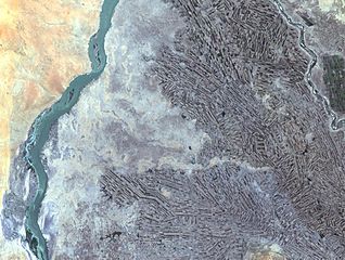
Farming along White and Blue Nile Rivers, near Khartoum, w:en:Sudan
In the Sahara Desert, along the White and Blue Nile rivers lies a thriving agricultural area. As seen in this Landsat 7 image, the farming patterns resemble French long farms, whose long, rectangular shapes allow each individual plot access to water from irrigation canals along the narrow side. The White Nile (left side of image) joins with the narrower Blue Nile (right side of image) a few miles further north at the city of Khartoum, Sudan, home to approximately 1 million of Sudan’s 33 million people. Sudan’s main crop is cotton, a very water-intensive crop for such an arid land. Surrounding Khartoum is the eastern Saharan Desert, noticeable as the reddish area in the upper left portion of the image.
http://landsat.usgs.gov/gallery/detail/384/
This image is in the public domain in the United States because it only contains materials that originally came from the United States Geological Survey, an agency of the United States Department of the Interior. For more information, see the official USGS copyright policy.
|
Првобитан дневник отпремања
| date/time | username | resolution | size | edit summary |
|---|---|---|---|---|
| 21:21, 24 October 2005 | w:en:User:Brian0918 | 1200×905 | 220 KB | Farming along White and Blue Nile Rivers, near Khartoum, <a href="/wiki/Sudan" title="Sudan">Sudan</a> In the Sahara Desert, along the White and Blue Nile rivers lies a thriving agricultural area. As seen in this Landsat 7 image, the farming patterns resemble French long farms, whose long, |
Image description page history
Историја датотеке
Кликните на датум/време да бисте видели тадашњу верзију датотеке.
| Датум/време | Минијатура | Димензије | Корисник | Коментар | |
|---|---|---|---|---|---|
| тренутна | 06:03, 16. септембар 2007. | | 1.200 × 905 (220 kB) | BetacommandBot | Transwiki approved by: w:en:User:Dmcdevit This image was copied from wikipedia:en. The original description was: Farming along White and Blue Nile Rivers, near Khartoum, w:en:Sudan In the Sahara Desert, along the White and Blue Nile rivers lies |
Употреба датотеке
Следећа страница користи ову датотеку:
Глобална употреба датотеке
Други викији који користе ову датотеку:
- Употреба на ar.wikipedia.org
- Употреба на ast.wikipedia.org
- Употреба на ca.wikipedia.org
- Употреба на en.wikipedia.org
- Употреба на es.wikipedia.org
- Употреба на fa.wikipedia.org
- Употреба на ig.wikipedia.org