
Датотека:Whitefish Bay, Door County, Wisconsin 2020.png

Величина овог приказа: 440 × 599 пиксела. 6 других резолуција: 176 × 240 пиксела | 353 × 480 пиксела | 564 × 768 пиксела | 752 × 1.024 пиксела | 1.505 × 2.048 пиксела | 9.321 × 12.687 пиксела.
Оригинална датотека (9.321 × 12.687 пиксела, величина датотеке: 216,34 MB, MIME тип: image/png)
| Ово је датотека са Викимедијине оставе. Информације са њене странице са описом приказане су испод. Викимедијина остава је складиште слободно лиценциралних мултимедијалних датотека. И Ви можете да помогнете. |
| Warning | The original file is very high-resolution. It might not load properly or could cause your browser to freeze when opened at full size. |
|---|
| Опис |
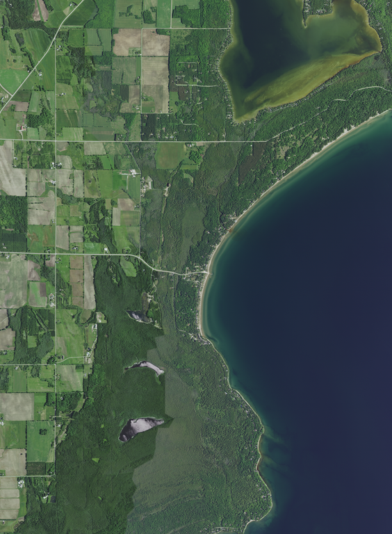
English: The unincorporated community of Whitefish Bay and vicinity in the town of Sevastopol, Door County, Wisconsin, Wisconsin, taken June 27, 2020. Interior lakes or seasonally inundated areas pictured, from north to south: Clark Lake, Lake of the Woods, Arbter Lake, and Schwartz Lake. Recreational areas pictured in whole or in part include Whitefish Dunes State Park (top, long exterior shore), Logan Creek State Natural Area far right hand corner, three town of Sevastopol parks: Town Line Boat Launch into Clark Lake (west of lake), Clark Lake Beach (south of lake), and the Whitefish Bay Boat Launch into Lake Michigan (center), Cave Point County Park (top right), the Places We Protect: Shivering Sands preserve (lower center) and the Cave Point-Clay Banks Shivering Sands Unit State Natural Area Map 559b (lower center). Wisconsin Rustic Road 9 follows near much of the shore area of of the photograph.
|
|||
| Датум | ||||
| Извор | converted to .png by Epiphyllumlover from the original .tif available as item M_4408707_SW_16_060_20200627 on EarthExplorer | |||
| Аутор | Aerial Photography Field Office (APFO) for NAIP, USGS; in contract with the Surdex Corporation | |||
| Дозвола (Поновно коришћење ове датотеке) |
|
|||
| Остале верзије |
.png)
.png)
.png)
.png)
.png)
Историја датотеке
Кликните на датум/време да бисте видели тадашњу верзију датотеке.
| Датум/време | Минијатура | Димензије | Корисник | Коментар | |
|---|---|---|---|---|---|
| тренутна | 08:42, 11. децембар 2021. | | 9.321 × 12.687 (216,34 MB) | Epiphyllumlover | c:User:Rillke/bigChunkedUpload.js: {{Information | Description = {{en|Whitefish Bay in Door County, Wisconsin, taken June 27, 2020. *Center Latitude 44°54'23.41"N *Center Longitude 87°13'06.66"W *NW Corner Lat 44°56'26.49"N *NW Corner Long 87°15'14.72"W *NE Corner Lat 44°56'26.98"N *NE Corner Long 87°10'59.54"W *SE Corner Lat 44°52'20.29"N *SE Corner Long 87°10'58.75"W *SW Corner Lat 44°52'19.80"N *SW Corner Long 87°15'13.64"W}} | Date... |
Употреба датотеке
Нема страница које користе ову датотеку.