
Датотека:Map of the Original City of Philadelphia in 1682 by Thomas Holme.jpg

Величина овог приказа: 800 × 565 пиксела. 6 других резолуција: 320 × 226 пиксела | 640 × 452 пиксела | 1.024 × 723 пиксела | 1.280 × 903 пиксела | 2.560 × 1.806 пиксела | 5.330 × 3.761 пиксела.
Оригинална датотека (5.330 × 3.761 пиксела, величина датотеке: 10,26 MB, MIME тип: image/jpeg)
| Ово је датотека са Викимедијине оставе. Информације са њене странице са описом приказане су испод. Викимедијина остава је складиште слободно лиценциралних мултимедијалних датотека. И Ви можете да помогнете. |
Опис измене
| Опис |
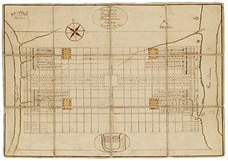
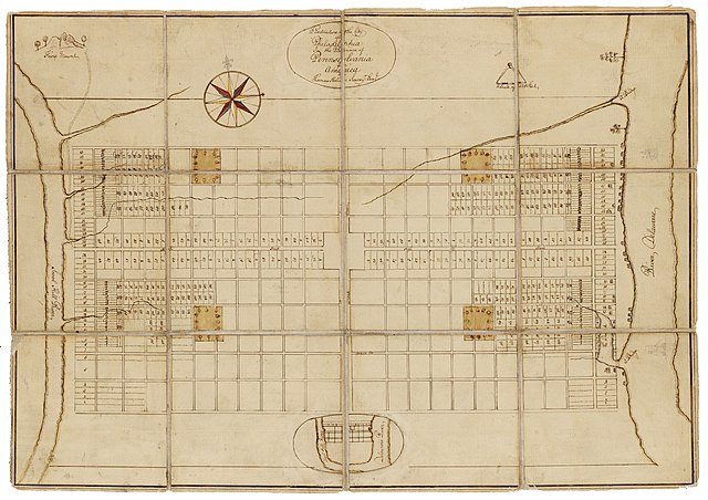
English: Holme, Thomas (1683). A Portraiture of the City of Philadelphia (map): In the province of Pennsylvania in America. London: Sold by Andrew Sowle in Shoreditch. In 1682, William Penn appointed Holme surveyor-general of Pennsylvania and charged him with the task of laying out the "greene country towne" that Penn envisioned along the Delaware River. The site that Penn acquired for the city of Philadelphia stretched two miles east to west across a tract of land situated between the Delaware and Schuylkill Rivers; all told, the rectangular grid of land comprised twelve thousand acres. Holme imposed an orderly grid plan on the site, with streets organized around a large square in the center of the town and four smaller squares, one in each quadrant. The grid also included two main streets, Broad and High (present-day Market), which were kept wide in hopes of preventing the kind of fire that destroyed London in 1666. Completed in 1683, this map was used for both reference and promotional purposes to show the unique layout of William's Penn emerging city. From the Historical Society of Pennsylvania: https://hsp.org/education/primary-sources/a-map-of-the-original-city-of-philadelphia |
| Датум | |
| Извор | https://hsp.org/education/primary-sources/a-map-of-the-original-city-of-philadelphia |
| Аутор | Thomas Holme |
Лиценцирање
Овај рад је у јавном власништву у Сједињеним Државама зато што је објављен или регистрован у канцеларији за ауторска права САД-а пре 1. јануара 1929.
Овај рад мора бити у јавном власништву у Сједињеним Државама и држави порекла да би се хостовао на Остави. Ако рад није дело америчког аутора, датотека обавезно мора имати и ознаку ауторских права за државу порекла да би се знало зашто је овај рад у јавном власништву у држави порекла.
|
Историја датотеке
Кликните на датум/време да бисте видели тадашњу верзију датотеке.
| Датум/време | Минијатура | Димензије | Корисник | Коментар | |
|---|---|---|---|---|---|
| тренутна | 22:57, 23. јануар 2020. | | 5.330 × 3.761 (10,26 MB) | N-gio | Sharpened focus, color, and contrast |
| 20:37, 23. јануар 2020. |  | 5.330 × 3.761 (1,9 MB) | N-gio | User created page with UploadWizard |
Употреба датотеке
Нема страница које користе ову датотеку.
Глобална употреба датотеке
Други викији који користе ову датотеку:
- Употреба на en.wikipedia.org
- Употреба на he.wikipedia.org
- Употреба на tr.wikipedia.org