
Датотека:OBLIQUE VIEW, TCI TWO-ROOM HOUSE WITH MULTIPLE LATER ADDITIONS TO ORIGINAL COMPANY HOUSE - Edgewater Community, Off New Mulga Loop Road (Junction 80), Birmingham, Jefferson HAER ALA,37-BIRM.V,7-2.tif

Величина JPG прегледа за ову TIF датотеку је 800 × 593 пиксела. 6 других резолуција: 320 × 237 пиксела | 640 × 474 пиксела | 1.024 × 759 пиксела | 1.280 × 948 пиксела | 2.560 × 1.896 пиксела | 5.000 × 3.704 пиксела.
Оригинална датотека (5.000 × 3.704 пиксела, величина датотеке: 17,66 MB, MIME тип: image/tiff)
| Ово је датотека са Викимедијине оставе. Информације са њене странице са описом приказане су испод. Викимедијина остава је складиште слободно лиценциралних мултимедијалних датотека. И Ви можете да помогнете. |
Опис измене
| OBLIQUE VIEW, TCI TWO-ROOM HOUSE WITH MULTIPLE LATER ADDITIONS TO ORIGINAL COMPANY HOUSE - Edgewater Community, Off New Mulga Loop Road (Junction 80), Birmingham, Jefferson County, AL | ||||
|---|---|---|---|---|
| Фотограф |
Lowe, Jet, creator |
|||
| Наслов |
OBLIQUE VIEW, TCI TWO-ROOM HOUSE WITH MULTIPLE LATER ADDITIONS TO ORIGINAL COMPANY HOUSE - Edgewater Community, Off New Mulga Loop Road (Junction 80), Birmingham, Jefferson County, AL |
|||
| Приказано место | Alabama; Jefferson County; Birmingham | |||
| Датум | 1993 | |||
| Димензије | 5 x 7 in. | |||
| Актуелна локација |
Library of Congress Prints and Photographs Division Washington, D.C. 20540 USA http://hdl.loc.gov/loc.pnp/pp.print |
|||
| Пописни број |
HAER ALA,37-BIRM.V,7-2 |
|||
| Порекло |
|
|||
| Извор | https://www.loc.gov/pictures/item/al1103.photos.046462p | |||
| Дозвола (Поновно коришћење ове датотеке) |
|
|||

| Положај камере | | Ова и друге слике снимљене у близини на: OpenStreetMap |
|---|
Историја датотеке
Кликните на датум/време да бисте видели тадашњу верзију датотеке.
| Датум/време | Минијатура | Димензије | Корисник | Коментар | |
|---|---|---|---|---|---|
| тренутна | 02:52, 1. јул 2014. | 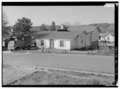 | 5.000 × 3.704 (17,66 MB) | Fæ | GWToolset: Creating mediafile for Fæ. HABS batch upload 29 June 2014 (101:150) |
Употреба датотеке
Следећа страница користи ову датотеку: