
Датотека:1918 British Government Map illustrating Territorial Negotiations between H.M.G. and King Hussein.png
Већа резолуција није доступна.
1918_British_Government_Map_illustrating_Territorial_Negotiations_between_H.M.G._and_King_Hussein.png (508 × 546 пиксела, величина датотеке: 489 kB, MIME тип: image/png)
| Ово је датотека са Викимедијине оставе. Информације са њене странице са описом приказане су испод. Викимедијина остава је складиште слободно лиценциралних мултимедијалних датотека. И Ви можете да помогнете. |
Опис
| Опис |
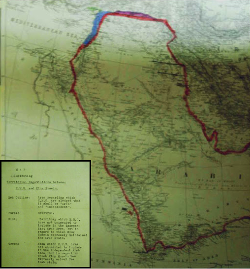
العربية: خريطة تعود لعام 1918 توضح الحدود الإقليمية للاراضي التي طالب بها الشريف الحسين أثناء المراسلات مع مكماهون
English: MPK 1/410 extracted from FO 371/4368; (7) Larger printed map, showing additionally the whole Arabian peninsula. Reference table. Scale: 1:6,969,600. Ms additions, coloured, mark several areas under discussion. Title affixed: 'Map illustrating Territorial Negotiations between H.M.G. amd King Hussein'; reference table to additions affixed. |
| Датум | |
| Извор | National Archives: http://discovery.nationalarchives.gov.uk/details/r/C3980431 |
| Аутор | UK Government |
Лиценцирање
Note: This map is not in copyright, since UK Crown Copyright for such materials expires 50 years after publication.
This work created by the United Kingdom Government is in the public domain.
This is because it is one of the following:
HMSO has declared that the expiry of Crown Copyrights applies worldwide (ref: HMSO Email Reply)
|
 |
Историја датотеке
Кликните на датум/време да бисте видели тадашњу верзију датотеке.
| Датум/време | Минијатура | Димензије | Корисник | Коментар | |
|---|---|---|---|---|---|
| тренутна | 23:54, 8. новембар 2016. | | 508 × 546 (489 kB) | Onceinawhile | User created page with UploadWizard |
Употреба датотеке
2 следеће странице користе ову датотеку:
Глобална употреба датотеке
Други викији који користе ову датотеку:
- Употреба на ar.wikipedia.org
- Употреба на azb.wikipedia.org
- Употреба на az.wikipedia.org
- Употреба на en.wikipedia.org
- Употреба на es.wikipedia.org
- Употреба на fa.wikipedia.org
- Употреба на fr.wikipedia.org
- Употреба на gl.wikipedia.org
- Употреба на hr.wikipedia.org
- Употреба на id.wikipedia.org
- Употреба на ko.wikipedia.org
- Употреба на ml.wikipedia.org
- Употреба на nl.wikipedia.org
- Употреба на ru.wikipedia.org