
Датотека:10May 16May Battle of Belgium.PNG

Veličina ovog prikaza: 775 × 599 piksela. 3 druge rezolucije: 311 × 240 piksela | 621 × 480 piksela | 891 × 689 piksela.
Originalna datoteka (891 × 689 piksela, veličina datoteke: 156 kB, MIME tip: image/png)
| Ovo je datoteka sa Vikimedijine ostave. Informacije sa njene stranice sa opisom prikazane su ispod. Vikimedijina ostava je skladište slobodno licenciralnih multimedijalnih datoteka. I Vi možete da pomognete. |
| Opis |
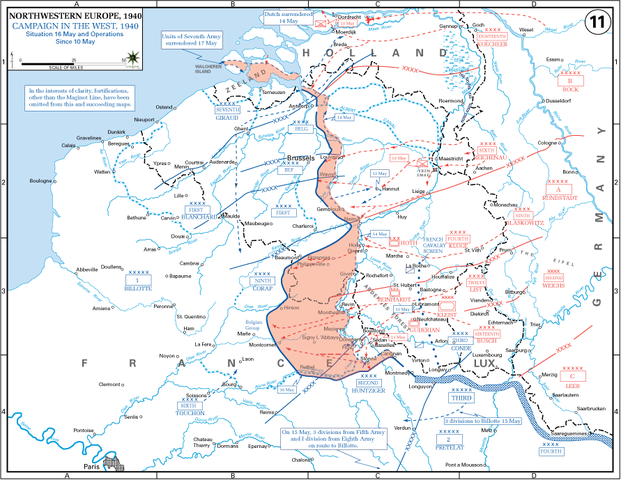
English: The German advance between 10 May and 16 May 1940. The red area denotes the territory captured by Germany during this time. The German field armies and Corps are shown in red. The red plan icon indicates the German airborne attack on the Belgian fortress of Eben-Emael. The operating area of the various Belgian, British, and French field armies and Army groups are shown in blue. The checkered white and blue area denotes the French Maginot Line. The commanders of the various units are shown under their respective formation. Solid lines represent the boundaries between each major unit. Dotted lines depict lines of advance. Key dates are shown in boxes. |
| Datum | (UTC) |
| Izvor |
(Original text: http://www.dean.usma.edu/history/web03/atlases/ww2%20europe/EuropeanTheaterGIF/WWIIEurope11.gif) Archive link to original website used for the map and the archive link to the map source page. Current link to map, and link to map source page. |
| Autor | The History Department of the United States Military Academy |
| Ostale verzije | File:10May-16May1940-Fall Gelb.jpg |
Licenciranje
Ова датотека је рад припадника Америчке војске или особе запослене у њој и начињена је за време обављања дужности те особе. Као рад америчке савезне владе, ова датотека је у јавном власништву у САД-у.
|
 |
Prvobitan dnevnik otpremanja
Transferred from en.wikipedia to Commons by Piotrus using CommonsHelper.
The original description page was here. All following user names refer to en.wikipedia.
- 2009-11-08 19:43 Coldplay Expert 891×689× (159258 bytes) {{Information |Description = The German advance until noon, 16 May 1940. The map also reveals the dispositions of the Belgian Army and its allies. |Source = http://www.dean.usma.edu/history/web03/atlases/ww2%20europe/EuropeanTheaterGIF/WWIIEu
Istorija datoteke
Kliknite na datum/vreme da biste videli tadašnju verziju datoteke.
| Datum/vreme | Minijatura | Dimenzije | Korisnik | Komentar | |
|---|---|---|---|---|---|
| trenutna | 20:35, 17. mart 2010. | | 891 × 689 (156 kB) | File Upload Bot (Magnus Manske) | {{BotMoveToCommons|en.wikipedia|year={{subst:CURRENTYEAR}}|month={{subst:CURRENTMONTHNAME}}|day={{subst:CURRENTDAY}}}} {{Information |Description={{en|The German advance until noon, 16 May 1940. The map also reveals the dispositions of the Belgian Army a |
Upotreba datoteke
Sledeća stranica koristi ovu datoteku:
Globalna upotreba datoteke
Drugi vikiji koji koriste ovu datoteku:
- Upotreba na azb.wikipedia.org
- Upotreba na ca.wikipedia.org
- Upotreba na en.wikipedia.org
- Battle of France
- 23rd (Northumbrian) Division
- French war planning 1920–1940
- British Expeditionary Force (World War II)
- 46th Infantry Division (United Kingdom)
- 12th (Eastern) Infantry Division
- Historiography of the Battle of France
- German radio intelligence operations during World War II
- Talk:World War II/Archive 53
- XIX Army Corps
- Upotreba na es.wikipedia.org
- Upotreba na fr.wikipedia.org
- Upotreba na hu.wikipedia.org
- Upotreba na ko.wikipedia.org
- Upotreba na ms.wikipedia.org
- Upotreba na nl.wikipedia.org
- Upotreba na pl.wikipedia.org
- Upotreba na ro.wikipedia.org
- Upotreba na ta.wikipedia.org
- Upotreba na th.wikipedia.org
- Upotreba na uk.wikipedia.org
- Upotreba na vi.wikipedia.org