
Датотека:16May-21May1940-Fall Gelb.svg

Veličina PNG pregleda za ovu SVG datoteku je 773 × 600 piksela. 6 drugih rezolucija: 309 × 240 piksela | 619 × 480 piksela | 990 × 768 piksela | 1.280 × 993 piksela | 2.560 × 1.987 piksela | 889 × 690 piksela.
Originalna datoteka (SVG datoteka, nominalno 889 × 690 piksela, veličina: 2,06 MB)
| Ovo je datoteka sa Vikimedijine ostave. Informacije sa njene stranice sa opisom prikazane su ispod. Vikimedijina ostava je skladište slobodno licenciralnih multimedijalnih datoteka. I Vi možete da pomognete. |
Opis izmene
| Opis |
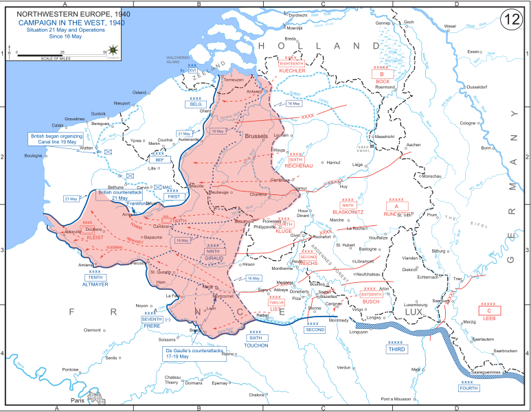
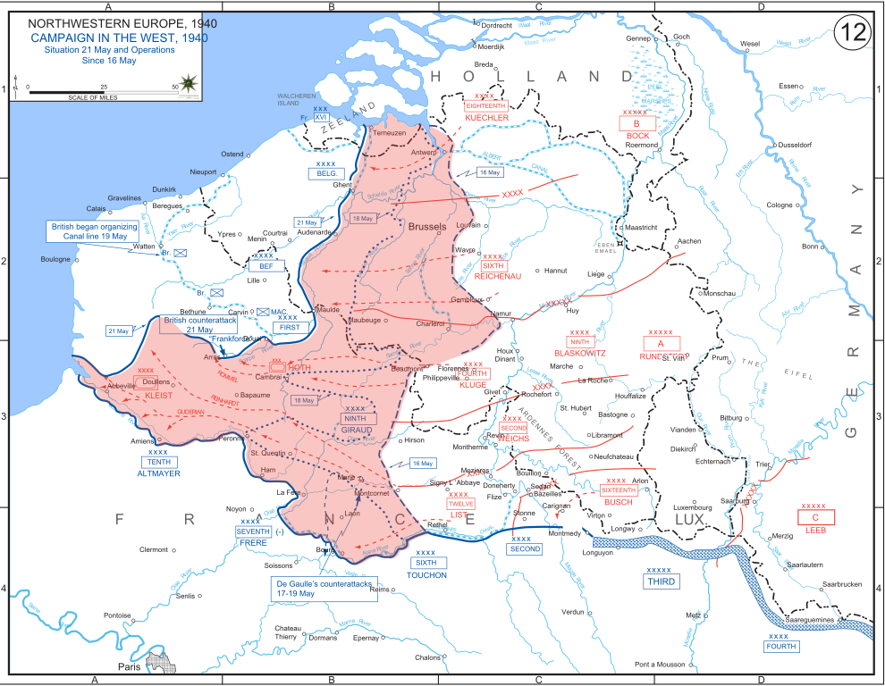
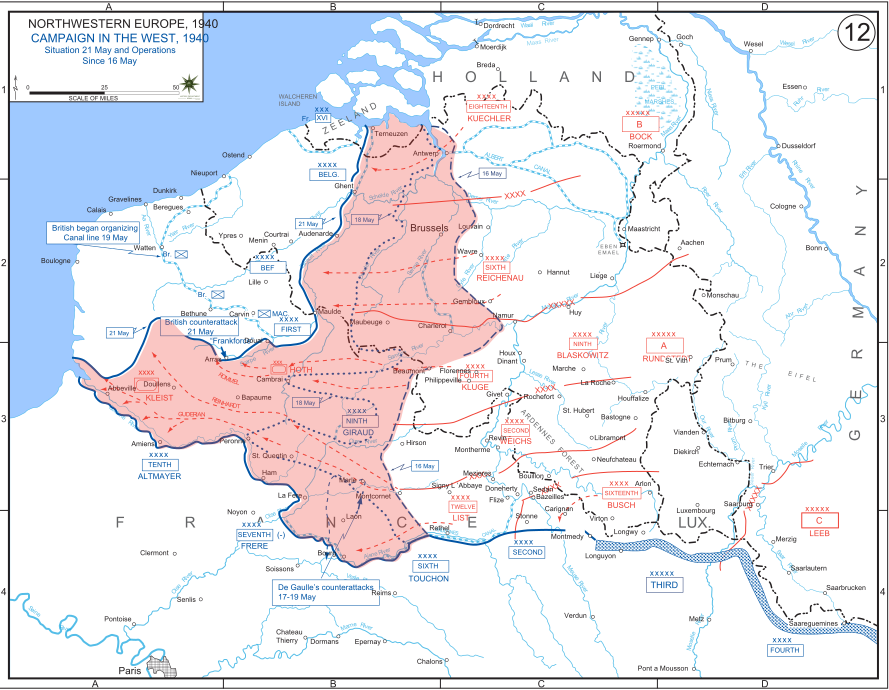
English: The German advance between 16 May and 21 May 1940. The red area denotes the territory captured by Germany during this time. The German field armies and Corps are shown in red. The operating area of the various Belgian, British, and French field armies and Army groups are shown in blue. The checkered white and blue area denotes the French Maginot Line. The commanders of the various units are shown under their respective formation. Solid lines represent the boundaries between each major unit. Dotted lines depict lines of advance. Key dates are shown in boxes. |
| Datum | |
| Izvor | Archive link to original website used for the map and the archive link to the map source page. Current link to map, and link to map source page. |
| Autor | The History Department of the United States Military Academy |
| Ostale verzije |
|


Licenciranje
Ова датотека је рад припадника Америчке војске или особе запослене у њој и начињена је за време обављања дужности те особе. Као рад америчке савезне владе, ова датотека је у јавном власништву у САД-у.
|
 |
Istorija datoteke
Kliknite na datum/vreme da biste videli tadašnju verziju datoteke.
| Datum/vreme | Minijatura | Dimenzije | Korisnik | Komentar | |
|---|---|---|---|---|---|
| trenutna | 21:07, 29. decembar 2011. | | 889 × 690 (2,06 MB) | Zscout370 | The text was displaying oddly in this SVG. |
| 21:07, 29. decembar 2011. |  | 889 × 690 (463 kB) | Addihockey10 | test | |
| 04:58, 24. septembar 2010. |  | 889 × 690 (334 kB) | Tazadeperla | {{Information |Description={{en|1=Vector version of file 1940FranceBlitz.jpg}} |Source=http://www.dean.usma.edu/history/web03/atlases/ww2%20europe/WWIIEuropeIndex.html |Author=The History Dept at the United States Army Academy |Date= |Permission= |other_v |
Upotreba datoteke
Sledeća stranica koristi ovu datoteku:
Globalna upotreba datoteke
Drugi vikiji koji koriste ovu datoteku:
- Upotreba na af.wikipedia.org
- Upotreba na ar.wikipedia.org
- Upotreba na azb.wikipedia.org
- Upotreba na bn.wikipedia.org
- Upotreba na br.wikipedia.org
- Upotreba na bs.wikipedia.org
- Upotreba na ca.wikipedia.org
- Upotreba na cs.wikipedia.org
- Upotreba na da.wikipedia.org
- Upotreba na en.wikipedia.org
- Upotreba na fi.wikipedia.org
- Upotreba na fr.wikipedia.org
- Upotreba na gl.wikipedia.org
- Upotreba na he.wikipedia.org
- Upotreba na id.wikipedia.org
- Upotreba na it.wikipedia.org
- Upotreba na ja.wikipedia.org
- Upotreba na ko.wikipedia.org
- Upotreba na lt.wikipedia.org
- Upotreba na lv.wikipedia.org
- Upotreba na nl.wikipedia.org
- Upotreba na no.wikipedia.org
- Upotreba na pl.wikipedia.org
- Upotreba na pt.wikipedia.org
- Upotreba na ro.wikipedia.org
- Upotreba na ru.wikipedia.org
- Upotreba na simple.wikipedia.org
- Upotreba na sl.wikipedia.org
- Upotreba na th.wikipedia.org
Još globalnog korišćenja ove datoteke.