
Датотека:1827 Finley Map of Vermont - Geographicus - Vermont-finely-1827.jpg

Veličina ovog prikaza: 471 × 600 piksela. 5 drugih rezolucija: 188 × 240 piksela | 377 × 480 piksela | 603 × 768 piksela | 804 × 1.024 piksela | 2.356 × 3.000 piksela.
Originalna datoteka (2.356 × 3.000 piksela, veličina datoteke: 1,78 MB, MIME tip: image/jpeg)
| Ovo je datoteka sa Vikimedijine ostave. Informacije sa njene stranice sa opisom prikazane su ispod. Vikimedijina ostava je skladište slobodno licenciralnih multimedijalnih datoteka. I Vi možete da pomognete. |
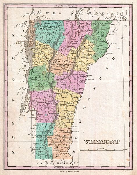
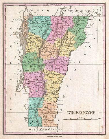
| Anthony Finley: Vermont.
( |
||||||||||||||
|---|---|---|---|---|---|---|---|---|---|---|---|---|---|---|
| Umetnik |
|
|||||||||||||
| Naslov |
Vermont. |
|||||||||||||
| Opis |
English: A beautiful example of Finley's important 1827 map of Vermont. Depicts the state with moderate detail in Finley's classic minimalist style. Shows river ways, roads, canals, and some topographical features. Offers color coding at the county level. Title and scale in lower right quadrant. It is very uncommon to find an early 19th century exclusively depicting Vermont, as most maps of the period bundled it with New Hampshire. Identifies Killington Peak and Camel's Hump, now popular ski resorts. Engraved by Young and Delleker for the 1827 edition of Anthony Finley's General Atlas . |
|||||||||||||
| Datum | 1827 (undated) | |||||||||||||
| Dimenzije | visina: 11,5 in (29,2 cm); širina: 9 in (22,8 cm) | |||||||||||||
| Popisni broj |
Geographicus link: Vermont-finely-1827 |
|||||||||||||
| Izvor/fotograf |
Finley, Anthony, A New General Altas, Comprising a Complete Set of Maps, representing the Grand Divisions of the Globe, Together with the several Empires, Kingdoms and States in the World; Compiled from the Best Authorities, and corrected by the Most Recent Discoveries, Philadelphia, 1827.
|
|||||||||||||
| Dozvola (Ponovno korišćenje ove datoteke) |
|
|||||||||||||
Istorija datoteke
Kliknite na datum/vreme da biste videli tadašnju verziju datoteke.
| Datum/vreme | Minijatura | Dimenzije | Korisnik | Komentar | |
|---|---|---|---|---|---|
| trenutna | 10:55, 23. mart 2011. | | 2.356 × 3.000 (1,78 MB) | BotMultichillT | {{subst:User:Multichill/Geographicus |link=http://www.geographicus.com/P/AntiqueMap/Vermont-finely-1827 |product_name=1827 Finley Map of Vermont |map_title=Vermont. |description=A beautiful example of Finley's important 1827 map of Vermont. Depicts the st |
Upotreba datoteke
Nema stranica koje koriste ovu datoteku.
Globalna upotreba datoteke
Drugi vikiji koji koriste ovu datoteku:
- Upotreba na bn.wikipedia.org
- Upotreba na en.wikipedia.org
- Upotreba na ja.wikipedia.org
- Upotreba na ko.wikipedia.org
- Upotreba na uk.wikipedia.org