
Датотека:1848 U.S. Coast Survey Map of New England - Geographicus - NewEngland-uscs-1848.jpg

Veličina ovog prikaza: 395 × 599 piksela. 6 drugih rezolucija: 158 × 240 piksela | 316 × 480 piksela | 506 × 768 piksela | 675 × 1.024 piksela | 1.350 × 2.048 piksela | 3.000 × 4.552 piksela.
Originalna datoteka (3.000 × 4.552 piksela, veličina datoteke: 2,15 MB, MIME tip: image/jpeg)
| Ovo je datoteka sa Vikimedijine ostave. Informacije sa njene stranice sa opisom prikazane su ispod. Vikimedijina ostava je skladište slobodno licenciralnih multimedijalnih datoteka. I Vi možete da pomognete. |
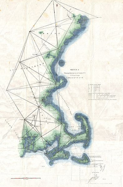
| Sketch A Showing the Progress in Section No. 1 U.S. Coast Survey in 1844 - 45 - 46 - 47 & - 48 | |||||
|---|---|---|---|---|---|
| Umetnik | |||||
| Naslov |
Sketch A Showing the Progress in Section No. 1 U.S. Coast Survey in 1844 - 45 - 46 - 47 & - 48 |
||||
| Opis |
English: A unusual triangulation chart of the New England coast line from the scarce 1848 edition of the Superintendent's Report . Covers from Nantucket and Marthas Vineyard north past Cape Code and Boston as far as Portland, Maine. Shows various triangulation point and some of the attached river systems. Includes some of the shoals discovered around Nantucket in the 1840s. The 1848 edition of the Superintendent's Report is highly unusual in that its maps do not have borders, was common in all subsequent editions. |
||||
| Datum | 1848 (dated) | ||||
| Dimenzije | visina: 23 in (58,4 cm); širina: 15 in (38,1 cm) | ||||
| Popisni broj |
Geographicus link: NewEngland-uscs-1848 |
||||
| Izvor/fotograf |
Report of the Superintendant of the United States Coast Survey, Washington, (1848 edition).
|
||||
| Dozvola (Ponovno korišćenje ove datoteke) |
|
||||
Istorija datoteke
Kliknite na datum/vreme da biste videli tadašnju verziju datoteke.
| Datum/vreme | Minijatura | Dimenzije | Korisnik | Komentar | |
|---|---|---|---|---|---|
| trenutna | 20:12, 24. mart 2011. | | 3.000 × 4.552 (2,15 MB) | BotMultichillT | {{subst:User:Multichill/Geographicus |link=http://www.geographicus.com/P/AntiqueMap/NewEngland-uscs-1848 |product_name=1848 U.S. Coast Survey Map of New England |map_title=Sketch A Showing the Progress in Section No. 1 U.S. Coast Survey in 1844 - 45 - 46 |
Upotreba datoteke
Sledeća stranica koristi ovu datoteku:
Globalna upotreba datoteke
Drugi vikiji koji koriste ovu datoteku:
- Upotreba na ar.wikipedia.org
- Upotreba na en.wikipedia.org