
Датотека:Balkan peninsula line.jpg
Veća rezolucija nije dostupna.
Balkan_peninsula_line.jpg (558 × 530 piksela, veličina datoteke: 169 kB, MIME tip: image/jpeg)
| Ovo je datoteka sa Vikimedijine ostave. Informacije sa njene stranice sa opisom prikazane su ispod. Vikimedijina ostava je skladište slobodno licenciralnih multimedijalnih datoteka. I Vi možete da pomognete. |
Opis izmene
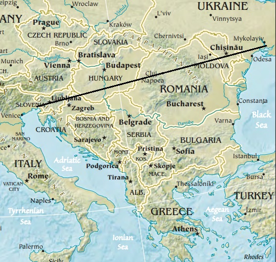
| Opis | Map of the Balkan peninsula, showing the line stretching from the northernmost point of the Adriatic to the northernmost point of the Black Sea. Made from Europe map at The Central Intelligence Agency World Factbook, which is in the public domain. |
| Izvor | https://www.cia.gov/library/publications/the-world-factbook//graphics/ref_maps/physical/jpg/europe.jpg |
| Autor | CIA |
| Ostale verzije |
|
.jpg)
Licenciranje
Ова слика или застава преузета је и/или модификована са интернет презентације Централне обавештајне агенције САД-а. По закону о ауторским правима САД-а, све информације и слике са сајта ЦИА-е су у јавном власништву.
|
 |

|
Ова map слика требало би да буду поново израђене као векторска графика у SVG формату. Тиме се остварује неколико предности. Више информација потражите на Commons:Media for cleanup. Ако је ова слика већ доступна у SVG формату, отпремите је. Након отпремања датотеке, овај шаблон замените шаблоном {{vector version available|new image name.svg}}.
|


Istorija datoteke
Kliknite na datum/vreme da biste videli tadašnju verziju datoteke.
| Datum/vreme | Minijatura | Dimenzije | Korisnik | Komentar | |
|---|---|---|---|---|---|
| trenutna | 14:27, 16. januar 2014. | | 558 × 530 (169 kB) | Denniss | Reverted to version as of 22:51, 26 December 2013 |
| 23:21, 15. januar 2014. |  | 348 × 382 (43 kB) | Ivan VA | stop vandalizing maps | |
| 00:51, 27. decembar 2013. |  | 558 × 530 (169 kB) | No More Cats | Please don't revert to outdated versions of maps | |
| 00:43, 27. decembar 2013. |  | 348 × 382 (43 kB) | Nikola Smolenski | Reverted to version as of 19:13, 3 November 2006 | |
| 18:06, 17. decembar 2013. |  | 558 × 530 (169 kB) | No More Cats | Map of the Balkan peninsula, showing the line stretching from the northernmost point of the Adriatic to the northernmost point of the Black Sea. Made from most recent map at [https://www.cia.gov/cia/publications/factbook/reference_maps/jpg/europe.jpg]. | |
| 21:13, 3. novembar 2006. |  | 348 × 382 (43 kB) | Nikola Smolenski | Map of the Balkan peninsula, showing the line stretching from the northernmost point of the Adriatic to the northernmost point of the Black Sea. Made from map at [https://www.cia.gov/cia/publications/factbook/reference_maps/jpg/europe.jpg]. |
Upotreba datoteke
Nema stranica koje koriste ovu datoteku.