
Датотека:Canada2.A2002165.1940.250m.jpg

Veličina ovog prikaza: 461 × 599 piksela. 6 drugih rezolucija: 184 × 240 piksela | 369 × 480 piksela | 591 × 768 piksela | 788 × 1.024 piksela | 1.575 × 2.048 piksela | 4.000 × 5.200 piksela.
Originalna datoteka (4.000 × 5.200 piksela, veličina datoteke: 2,83 MB, MIME tip: image/jpeg)
| Ovo je datoteka sa Vikimedijine ostave. Informacije sa njene stranice sa opisom prikazane su ispod. Vikimedijina ostava je skladište slobodno licenciralnih multimedijalnih datoteka. I Vi možete da pomognete. |
Opis izmene
| Opis |
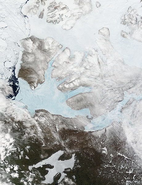
English: These Moderate resolution Imaging Spectroradiometer Images from June 14 and 16, 2002, show Banks Island (upper left) and Victoria Island (to the southeast) in the Arctic Ocean off northwest Canada. Left of center in each image is Amundsen Gulf, looking bright blue as this arm of the Beaufort Sea (at the southern end of the Arctic Ocean) begins to thaw. At the bottom of the images, the tundra of the Northwest Territories (left) and the Nunavut (right) Provinces of Canada is beginning to lose its winter snow cover. At bottom center of the portrait oriented image is Great Bear lake--still frozen. |
| Datum | June 14 and 16, 2002 |
| Izvor | http://visibleearth.nasa.gov/view_rec.php?id=3342 |
| Autor | Jacques Descloitres, MODIS Land Rapid Response Team, NASA/GSFC |
Licenciranje
| Ова датотека је у јавном власништву зато што је њен аутор НАСА. НАСА-а политика ауторских права наводи „Материјали НАСА-е нису заштићени ауторским правима осим ако није другачије наведено“. (Погледајте Template:PD-USGov, NASA copyright policy page или JPL Image Use Policy.) | ||
 |
Упозорења:
|
Istorija datoteke
Kliknite na datum/vreme da biste videli tadašnju verziju datoteke.
| Datum/vreme | Minijatura | Dimenzije | Korisnik | Komentar | |
|---|---|---|---|---|---|
| trenutna | 19:59, 20. avgust 2008. | | 4.000 × 5.200 (2,83 MB) | Ando228 | {{Information |Description={{en|1=These Moderate resolution Imaging Spectroradiometer Images from June 14 and 16, 2002, show Banks Island (upper left) and Victoria Island (to the southeast) in the Arctic Ocean off northwest Canada. Left of center in each |
Upotreba datoteke
2 sledeće stranice koriste ovu datoteku:
Globalna upotreba datoteke
Drugi vikiji koji koriste ovu datoteku:
- Upotreba na af.wikipedia.org
- Upotreba na ar.wikipedia.org
- Upotreba na ast.wikipedia.org
- Upotreba na az.wikipedia.org
- Upotreba na be.wikipedia.org
- Upotreba na bg.wikipedia.org
- Upotreba na bn.wikipedia.org
- Upotreba na ca.wikipedia.org
- Upotreba na ceb.wikipedia.org
- Upotreba na cy.wikipedia.org
- Upotreba na da.wikipedia.org
- Upotreba na de.wikivoyage.org
- Upotreba na diq.wikipedia.org
- Upotreba na en.wikipedia.org
- Upotreba na es.wikipedia.org
- Upotreba na eu.wikipedia.org
- Upotreba na fa.wikipedia.org
- Upotreba na fi.wikipedia.org
- Upotreba na fr.wikipedia.org
- Upotreba na fr.wikivoyage.org
- Upotreba na fy.wikipedia.org
- Upotreba na ga.wikipedia.org
- Upotreba na gl.wikipedia.org
- Upotreba na he.wikipedia.org
- Upotreba na hu.wikipedia.org
- Upotreba na hy.wikipedia.org
- Upotreba na ilo.wikipedia.org
- Upotreba na is.wikipedia.org
- Upotreba na it.wikipedia.org
- Upotreba na ja.wikipedia.org
- Upotreba na ko.wikipedia.org
- Upotreba na ku.wikipedia.org
- Upotreba na la.wikipedia.org
- Upotreba na lv.wikipedia.org
- Upotreba na ml.wikipedia.org
- Upotreba na mzn.wikipedia.org
- Upotreba na nl.wikipedia.org
- Upotreba na nn.wikipedia.org
Još globalnog korišćenja ove datoteke.