
Датотека:End.of.Roman.rule.in.Britain.383.410.jpg

Originalna datoteka (2.582 × 3.220 piksela, veličina datoteke: 1.010 kB, MIME tip: image/jpeg)
| Ovo je datoteka sa Vikimedijine ostave. Informacije sa njene stranice sa opisom prikazane su ispod. Vikimedijina ostava je skladište slobodno licenciralnih multimedijalnih datoteka. I Vi možete da pomognete. |
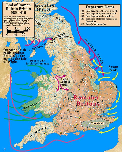
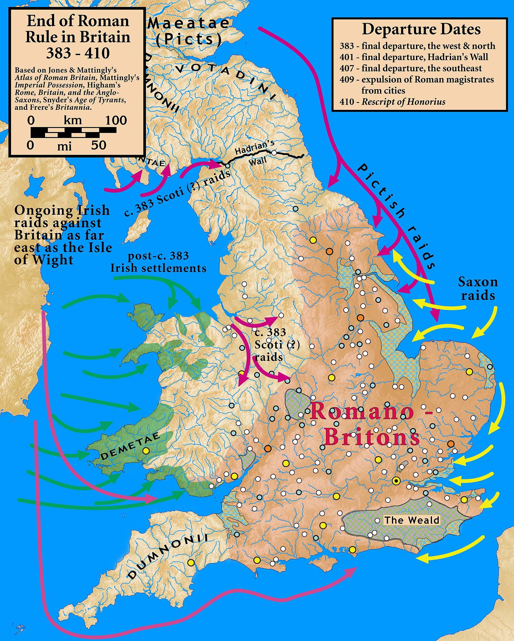
| Opis | End of Roman Rule in Britain, 383–410 |
| Datum | |
| Izvor |
Based on Jones & Mattingly's Atlas of Roman Britain (ISBN 978-1-84217-06700, 1990, reprinted 2007); Mattingly's Imperial Possession ( ISBN 978-0-140-14822-0, 2006); Higham's Rome, Britain, and the Anglo-Saxons (ISBN 1-85264-022-7, 1992); Frere's Britannia (ISBN 0-7102-1215-1, 1987); and Snyder's An Age of Tyrants (ISBN 978-0-631-22260-6) — the sources are cited in the image legend — Locations of towns (fortified and unfortified) are given on p. 156, with tribal civitates and coloniae specified on p. 154, of Atlas of Roman Britain. Specification of the Romanized regions of Britain are also from the Atlas, p. 151. The "Departure Dates" are found in the cited sources, and are generally known. The Pictish, Saxon, and Scoti raids are found in the cited sources, as is the date of the Irish settlements in Wales. Frere suggests (p. 355) that it was the Irish who sacked Wroxeter c. 383. The locations of the Irish settlements is from the locations of inscription stones given in File:Britain.Deisi.Laigin.jpg as of 2010-10-11, which cites its sources of information.
|
| Autor | my work |
- Dozvoljeno je:
- da delite – da umnožavate, raspodeljujete i prenosite delo
- da prerađujete – da preradite delo
- Pod sledećim uslovima:
- autorstvo – Morate da date odgovarajuće zasluge, obezbedite vezu ka licenci i naznačite da li su izmene napravljene. Možete to uraditi na bilo koji razuman manir, ali ne na način koji predlaže da licencator odobrava vas ili vaše korišćenje.
- deliti pod istim uslovima – Ako izmenite, preobrazite ili dogradite ovaj materijal, morate podeliti svoje doprinose pod istom ili kompatibilnom licencom kao original.

|
Ова historical map слика требало би да буду поново израђене као векторска графика у SVG формату. Тиме се остварује неколико предности. Више информација потражите на Commons:Media for cleanup. Ако је ова слика већ доступна у SVG формату, отпремите је. Након отпремања датотеке, овај шаблон замените шаблоном {{vector version available|new image name.svg}}.
|


Istorija datoteke
Kliknite na datum/vreme da biste videli tadašnju verziju datoteke.
| Datum/vreme | Minijatura | Dimenzije | Korisnik | Komentar | |
|---|---|---|---|---|---|
| trenutna | 22:07, 18. oktobar 2010. | | 2.582 × 3.220 (1.010 kB) | Notuncurious | {{Information |Description=End of Roman Rule in Britain, 383–410 |Source=Based on Jones & Mattingly's ''Atlas of Roman Britain'' (ISBN 978-1-84217-06700, 1990, reprinted 2007); Mattingly's ''Imperial Possession'' ( ISBN 978-0-140-14822-0, 2006); Hig |
Upotreba datoteke
2 sledeće stranice koriste ovu datoteku:
Globalna upotreba datoteke
Drugi vikiji koji koriste ovu datoteku:
- Upotreba na ar.wikipedia.org
- Upotreba na ast.wikipedia.org
- Upotreba na be.wikipedia.org
- Upotreba na bn.wikipedia.org
- Upotreba na ca.wikipedia.org
- Upotreba na da.wikipedia.org
- Upotreba na en.wikipedia.org
- Upotreba na es.wikipedia.org
- Upotreba na et.wikipedia.org
- Upotreba na fa.wikipedia.org
- Upotreba na fr.wikipedia.org
- Upotreba na gl.wikipedia.org
- Upotreba na hr.wikipedia.org
- Upotreba na it.wikipedia.org
- Upotreba na ja.wikipedia.org
- Upotreba na lfn.wikipedia.org
- Upotreba na pnb.wikipedia.org
- Upotreba na pt.wikipedia.org
- Upotreba na ro.wikipedia.org
- Upotreba na ru.wikipedia.org
- Upotreba na sh.wikipedia.org
- Upotreba na tr.wikipedia.org
- Upotreba na ur.wikipedia.org
- Upotreba na www.wikidata.org
- Upotreba na zh.wikipedia.org