
Датотека:Great Lakes bathymetry map.png
Originalna datoteka (1.024 × 731 piksela, veličina datoteke: 1,34 MB, MIME tip: image/png)
| Ovo je datoteka sa Vikimedijine ostave. Informacije sa njene stranice sa opisom prikazane su ispod. Vikimedijina ostava je skladište slobodno licenciralnih multimedijalnih datoteka. I Vi možete da pomognete. |
Opis izmene
| Opis |
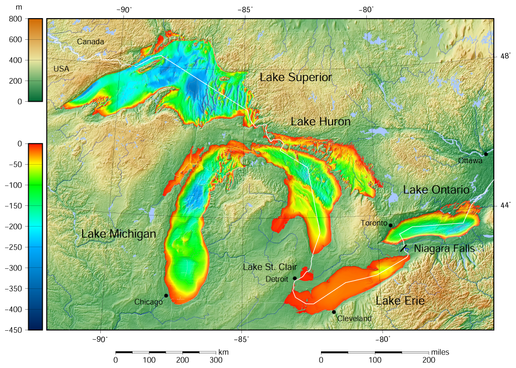
English: Great Lakes bathymetry and surrounding area shaded relief map. Lakes are contoured with interval 100 m. Lake Superior is incomplete. |
| Datum | |
| Izvor |
Own work using: the following Public Domain datasets (grids):
The color palette of the depth scale was made to be more or less similar to the color palettes used on the NGDC Great Lakes maps. |
| Autor | Darekk2 using the Great Lakes Bathymetry and GLOBE tiles |
| Ostale verzije |
|

Licenciranje
Attribution (in addition to the author of this map):
The NGDC in it's copyright notice says:
As required by 17 U.S.C. 403, third parties producing copyrighted works consisting predominantly of the material produced by U.S. government agencies must provide notice with such work(s) identifying the U.S. Government material incorporated and stating that such material is not subject to copyright protection within the United States. (...)
(for credits see the Source section).
and Great Lakes Bathymetry and GLOBE
(see above and the Source section)
- Dozvoljeno je:
- da delite – da umnožavate, raspodeljujete i prenosite delo
- da prerađujete – da preradite delo
- Pod sledećim uslovima:
- autorstvo – Morate da date odgovarajuće zasluge, obezbedite vezu ka licenci i naznačite da li su izmene napravljene. Možete to uraditi na bilo koji razuman manir, ali ne na način koji predlaže da licencator odobrava vas ili vaše korišćenje.
- deliti pod istim uslovima – Ako izmenite, preobrazite ili dogradite ovaj materijal, morate podeliti svoje doprinose pod istom ili kompatibilnom licencom kao original.
Istorija datoteke
Kliknite na datum/vreme da biste videli tadašnju verziju datoteke.
| Datum/vreme | Minijatura | Dimenzije | Korisnik | Komentar | |
|---|---|---|---|---|---|
| trenutna | 17:46, 9. maj 2015. | | 1.024 × 731 (1,34 MB) | Darekk2 | more accurate shorelines, the lakes tiles better assembled, added Canada, USA and Lake St. Clair labels, moved Detroit label, Michigan Lake - retouched western part of Green Bay |
| 12:03, 25. mart 2015. |  | 1.024 × 731 (1,34 MB) | Darekk2 | changed illumination for shaded relief | |
| 03:29, 25. mart 2015. |  | 1.024 × 731 (1,33 MB) | Darekk2 | changed palette a little | |
| 22:21, 24. mart 2015. |  | 1.024 × 731 (1,61 MB) | Darekk2 | User created page with UploadWizard |
Upotreba datoteke
Sledeća stranica koristi ovu datoteku:
Globalna upotreba datoteke
Drugi vikiji koji koriste ovu datoteku:
- Upotreba na ar.wikipedia.org
- Upotreba na crh.wikipedia.org
- Upotreba na en.wikipedia.org
- Upotreba na fi.wikipedia.org
- Upotreba na ja.wikipedia.org
- Upotreba na nl.wikipedia.org
- Upotreba na tt.wikipedia.org
- Upotreba na uk.wikipedia.org
- Upotreba na vep.wikipedia.org
- Upotreba na www.wikidata.org
- Upotreba na zh-yue.wikipedia.org