
Датотека:Great Schism 1054 with former borders.png

Veličina ovog prikaza: 560 × 599 piksela. 5 drugih rezolucija: 224 × 240 piksela | 448 × 480 piksela | 717 × 768 piksela | 957 × 1.024 piksela | 2.000 × 2.141 piksela.
Originalna datoteka (2.000 × 2.141 piksela, veličina datoteke: 420 kB, MIME tip: image/png)
| Ovo je datoteka sa Vikimedijine ostave. Informacije sa njene stranice sa opisom prikazane su ispod. Vikimedijina ostava je skladište slobodno licenciralnih multimedijalnih datoteka. I Vi možete da pomognete. |

|
Ова religion map слика требало би да буду поново израђене као векторска графика у SVG формату. Тиме се остварује неколико предности. Више информација потражите на Commons:Media for cleanup. Ако је ова слика већ доступна у SVG формату, отпремите је. Након отпремања датотеке, овај шаблон замените шаблоном {{vector version available|new image name.svg}}.
|
Opis izmene
| Opis |
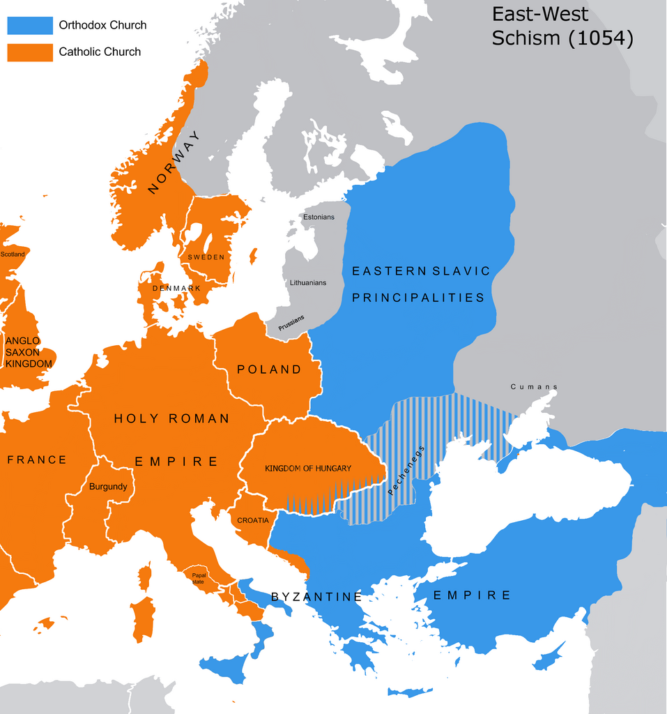
English: The map of the eastern/western allegiances in 1054 with the former country borders.
Español: El mapa de las creencias en el este/oeste en 1054 con las fronteras del país anterior. Los puntos representan concentraciones de minorías y no ubicaciones específicas. Las líneas rayadas representan cohabitaciones religiosas y no mayorías (que están representadas por colores sólidos).
Deutsch: Karte über das Morgenländische Schisma mit den ehemaligen Landesgrenzen. Die schraffierten Linien stellen religiöse Zusammenleben und keine Mehrheiten dar (die durch Vollfarben dargestellt werden).
Magyar: A nagy kelet-nyugati egyházszakadás térképe az 1054-nek megfelelő határokkal. A pontok a kisebbségek koncentrációját jelölik, nem pedig meghatározott helyeket. A sraffozott vonalak a vallási együttéléseket jelölik, nem pedig a többséget (amelyeket egyszínű színek jelölnek). |
||
| Datum | 04.09.2010. | ||
| Izvor | Source: Westermanns Atlas zur Weltgeschichte, 1957, p. 64-5, maps titled "Staaten u. Bekenntnisse im Mittelmeerraum nach den ersten Kreuzzügen (um 1190)" (p. 64) and "Mittelmeerwelt und Vorderasien vor Beginn der Kreuzzüge (1096)" (p. 65) and Alexander Kazhdan (dir.), Oxford Dictionary of Byzantium, Oxford University Press, 1991, 1re éd., 3 tom. (ISBN 978-0-19-504652-6, LCCN 90023208), art. « Patriarchates », vol. 3, pp. 1599-1600. | ||
| Autor | Tobi85 | ||
| Dozvola (Ponovno korišćenje ove datoteke) |
|
||
| Ostale verzije | Derivative works of this file: Great Schism 1054 with former borders-ar.png |
Licenciranje
| Ja, tvorac ovog dela, predajem ga u javno vlasništvo. Ovo se odnosi na ceo svet. U nekim zemljama, ovo nije zakonski moguće; u tom slučaju: Ja, tvorac ovog dela dozvoljavam svakome da koristi ovo delo za bilo koju namenu, bez bilo kakvih uslova, osim uslova koje nameće zakon. |
_en.png)
.png)
.jpg)
Istorija datoteke
Kliknite na datum/vreme da biste videli tadašnju verziju datoteke.
| Datum/vreme | Minijatura | Dimenzije | Korisnik | Komentar | |
|---|---|---|---|---|---|
| trenutna | 15:16, 9. jul 2023. | | 2.000 × 2.141 (420 kB) | Veverve | Reverted to version as of 21:25, 11 November 2022 (UTC): this is a huge extrapolation to make based solely on the fact that there were some Byzantine churches in Hungary |
| 17:01, 19. mart 2023. |  | 2.000 × 2.141 (439 kB) | Moodylo333 | Reverted to 8 November 2017 according with Dora Wiebenson, József Sisa, Pál Lövei, "The architecture of historic Hungary" (p. 11) who admit the presence of byzantine churches in Eastern Hungary. | |
| 23:25, 11. novembar 2022. |  | 2.000 × 2.141 (420 kB) | Gyalu22 | As Veverve said, no personal opinions should be used. The previous status in Hungary was drawn by Cepleanu who referred to the Westermanns Atlas in the talk page. But that atlas shows the situation very differently. | |
| 21:58, 23. oktobar 2022. |  | 2.000 × 2.141 (479 kB) | Veverve | Reverted to version as of 11:04, 1 June 2022 (UTC) original research and personnal opinions should no be used | |
| 21:12, 23. oktobar 2022. |  | 2.000 × 2.141 (492 kB) | Gyalu22 | Religion was not an ethnic question. Transylvania was a religiously diverse region, but Catholicism was already dominant to Alba Iulia | |
| 13:04, 1. jun 2022. |  | 2.000 × 2.141 (479 kB) | Moodylo333 | Reliable version with Alexander Kazhdan (dir.), Oxford Dictionary of Byzantium, New York et Oxford, Oxford University Press, 1991, 1re éd., 3 tom. (ISBN 978-0-19-504652-6 et 0-19-504652-8, LCCN 90023208), 1991, art. « Patriarchates », vol. 3, pp. 1599-1600. | |
| 15:51, 1. februar 2022. |  | 2.000 × 2.141 (488 kB) | Moodylo333 | Reverted to version as of 20:17, 8 July 2018 (UTC) without Bogomils (off topic) | |
| 15:49, 1. februar 2022. |  | 2.000 × 2.141 (488 kB) | Moodylo333 | Reverted to version as of 20:15, 8 July 2018 (UTC) : COM:CROP | |
| 11:41, 26. novembar 2021. |  | 2.000 × 2.141 (420 kB) | Veverve | Reverted to version as of 15:53, 26 October 2011 (UTC) revert to version closer to the Westermanns Atlas zur Weltgeschichte, see File_talk:Great_Schism_1054_with_former_borders.png#Numerous_problems,_map_is_unreliable | |
| 01:18, 30. maj 2021. |  | 2.000 × 2.141 (494 kB) | Ceha | Catholic-ortodox borders in the southeast |
Upotreba datoteke
Nema stranica koje koriste ovu datoteku.
Globalna upotreba datoteke
Drugi vikiji koji koriste ovu datoteku:
- Upotreba na ar.wikipedia.org
- Upotreba na ca.wikipedia.org
- Upotreba na cs.wikipedia.org
- Upotreba na de.wikipedia.org
- Upotreba na de.wikibooks.org
- Upotreba na en.wikipedia.org
- Upotreba na fr.wikipedia.org
- Upotreba na ga.wikipedia.org
- Upotreba na hu.wikipedia.org
- Upotreba na ro.wikipedia.org
- Upotreba na www.wikidata.org