
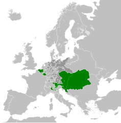
Датотека:Habsburg Monarchy 1789.svg

Veličina PNG pregleda za ovu SVG datoteku je 450 × 456 piksela. 5 drugih rezolucija: 237 × 240 piksela | 474 × 480 piksela | 758 × 768 piksela | 1.011 × 1.024 piksela | 2.021 × 2.048 piksela.
Originalna datoteka (SVG datoteka, nominalno 450 × 456 piksela, veličina: 857 kB)
| Ovo je datoteka sa Vikimedijine ostave. Informacije sa njene stranice sa opisom prikazane su ispod. Vikimedijina ostava je skladište slobodno licenciralnih multimedijalnih datoteka. I Vi možete da pomognete. |
Opis izmene


.svg)
.svg)
.svg)
.svg)
.svg)


.svg)
.svg)
.svg)


.png)
.png)


.svg)


.svg)

.svg)


.svg)
.svg)
.svg)
.svg)


.svg)
.png)


.svg)


.svg)
.svg)


.svg)


.svg)


.svg)
.svg)
.svg)
.svg)
.svg)
.svg)
.svg)
_cropped.svg)
.svg)
.svg)
.svg)
.svg)
.svg)
.svg)
.svg)
.svg)
.svg)
.svg)
.svg)
.svg)
.svg)
.svg)
.svg)
.svg)
.svg)
.svg)
.svg)
.svg)
.svg)
.svg)
.svg)
.svg)
.svg)
.svg)
.svg)
.svg)
.svg)
.svg)
.svg)
.svg)
.svg)
.svg)
.svg)
.svg)
.svg)
.svg)
.svg)
.svg)
.svg)
.svg)
.svg)
.svg)
.svg)
Licenciranje
Ja, nosilac autorskog prava nad ovim delom, objavljujem isto pod sledećom licencom:
Ova datoteka je dostupna pod licencom Creative Commons Autorstvo-Deliti pod istim uslovima 3.0 Unported.
- Dozvoljeno je:
- da delite – da umnožavate, raspodeljujete i prenosite delo
- da prerađujete – da preradite delo
- Pod sledećim uslovima:
- autorstvo – Morate da date odgovarajuće zasluge, obezbedite vezu ka licenci i naznačite da li su izmene napravljene. Možete to uraditi na bilo koji razuman manir, ali ne na način koji predlaže da licencator odobrava vas ili vaše korišćenje.
- deliti pod istim uslovima – Ako izmenite, preobrazite ili dogradite ovaj materijal, morate podeliti svoje doprinose pod istom ili kompatibilnom licencom kao original.
Prvobitan dnevnik otpremanja
This image is a derivative work of the following images:
- File:Europe_1789.svg licensed with Cc-by-sa-3.0
- 2013-04-14T01:38:01Z Alphathon 450x456 (853881 Bytes) tweaked again
- 2013-04-14T01:36:10Z Alphathon 450x456 (853881 Bytes) Tweaked Holy Roman Empire border style
- 2013-04-14T01:33:26Z Alphathon 450x456 (853857 Bytes) == {{int:filedesc}} == {{Information |Description={{en|A blank Map of Europe circa 1789. This map also includes a border for the [[:en:Holy Roman Empire|Holy Roman Empire]]. Since there are so many small German states, they h
Uploaded with derivativeFX
Istorija datoteke
Kliknite na datum/vreme da biste videli tadašnju verziju datoteke.
| Datum/vreme | Minijatura | Dimenzije | Korisnik | Komentar | |
|---|---|---|---|---|---|
| trenutna | 09:54, 17. oktobar 2021. | | 450 × 456 (857 kB) | Fenn-O-maniC | Fixed the Russo-Swedish border to match the Treaty of Åbo of 1743 |
| 22:27, 18. april 2013. |  | 450 × 456 (877 kB) | Alphathon | Style changes | |
| 19:22, 18. april 2013. |  | 450 × 456 (856 kB) | Alphathon | HRE border | |
| 19:19, 18. april 2013. |  | 450 × 456 (820 kB) | Alphathon | Various fixes | |
| 16:48, 18. april 2013. |  | 450 × 456 (853 kB) | Alphathon | Fixed Scandinavian borders | |
| 05:47, 14. april 2013. |  | 450 × 456 (839 kB) | Alphathon | As main version | |
| 03:59, 14. april 2013. |  | 450 × 456 (831 kB) | Alphathon | == {{int:filedesc}} == {{Information |Description={{en|A map of the Habsburg Monarchy circa 1789.}}{{de|Eine Landkarte die Habsburgermonarchie, c. 1989.}} |Source={{Derived from|Europe_1789.svg|disp... |
Upotreba datoteke
Sledeća stranica koristi ovu datoteku:
Globalna upotreba datoteke
Drugi vikiji koji koriste ovu datoteku:
- Upotreba na cs.wikipedia.org
- Upotreba na de.wikipedia.org
- Upotreba na en.wikipedia.org
- Upotreba na es.wikipedia.org
- Upotreba na fr.wikipedia.org
- Upotreba na it.wikipedia.org
- Upotreba na lt.wikipedia.org
- Upotreba na pl.wikipedia.org
- Upotreba na sv.wikipedia.org