
Датотека:Jewel-Toned Lakes of the Qinghai-Tibet Plateau.jpg

Veličina ovog prikaza: 615 × 600 piksela. 6 drugih rezolucija: 246 × 240 piksela | 492 × 480 piksela | 788 × 768 piksela | 1.050 × 1.024 piksela | 2.101 × 2.048 piksela | 7.940 × 7.740 piksela.
Originalna datoteka (7.940 × 7.740 piksela, veličina datoteke: 7 MB, MIME tip: image/jpeg)
| Ovo je datoteka sa Vikimedijine ostave. Informacije sa njene stranice sa opisom prikazane su ispod. Vikimedijina ostava je skladište slobodno licenciralnih multimedijalnih datoteka. I Vi možete da pomognete. |
| Warning | The original file is very high-resolution. It might not load properly or could cause your browser to freeze when opened at full size. |
|---|
Opis izmene
| Opis |
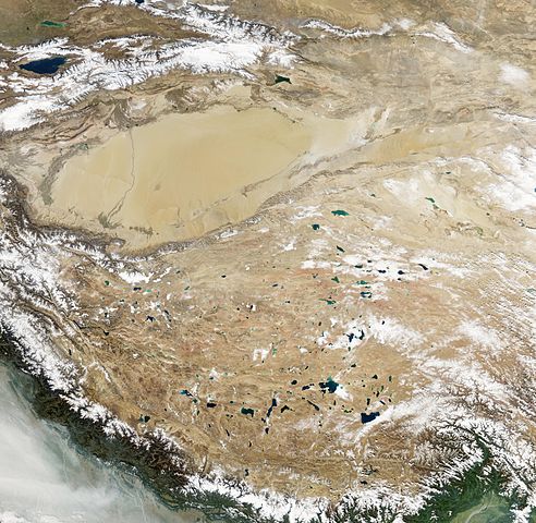
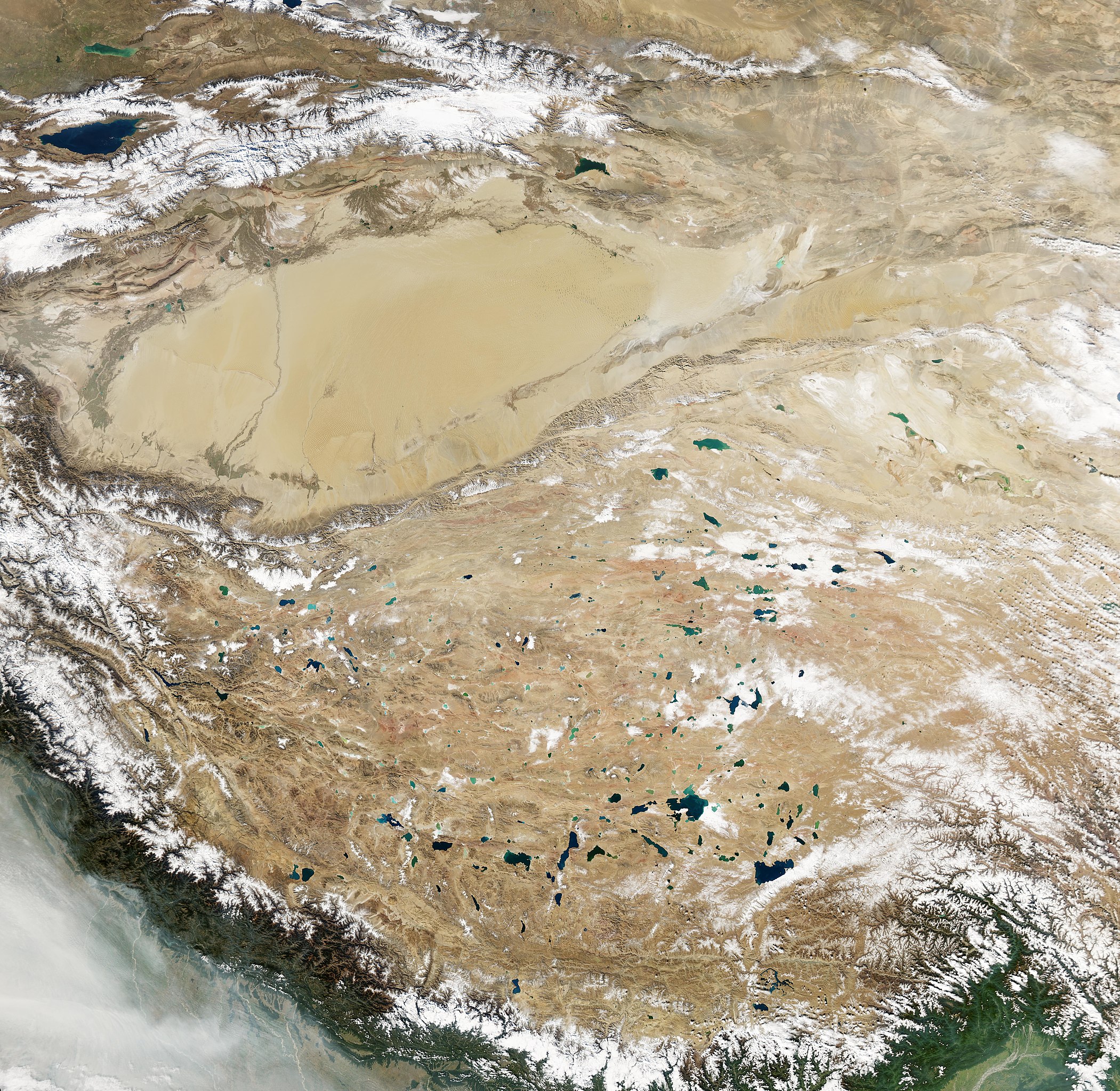
English: Natural-colour image of the Tibetan Plateau. The Qinghai-Tibet Plateau not only gives rise to most of Asia’s major rivers, it also holds a constellation of salt- and freshwater lakes. Due to differences in depth, sediments, and microscopic organisms in the various lakes, they collectively present a myriad of greens, blues, and teals when viewed from above. Resembling bits of abalone shell, the lakes glimmer in assorted jewel tones. The lakes in this region typically lack outlets, allowing the accumulation of minerals that, combined with other features, influence lake colour. The lakes vary widely in surface area and shape. Two of the largest in this scene are Siling Co and Nam Co. One of the most irregularly shaped lakes is Ngangla Ringco.
Nam Co ranks among the world’s highest-altitude salt lakes, with a lake surface at 4,718 meters. It measures roughly 79 by 25 kilometres and, except for areas along the south-western and north-eastern margins, the lake appears nearly uniform blue. Siling Co’s shape and colour vary more than Nam Co’s. The lake’s blue-green hue ranges from light (in the north and east) to dark (in the south and west). Fringing the lake are smaller water bodies, which all used to be part of a larger lake. Lying to the west, Ngangla Ringco is one of the most unusually shaped water bodies on the Qinghai-Tibet Plateau, with colours ranging from turquoise to sapphire. Small islands dot the surface in the west, and a large island sits in the lake’s eastern half. |
| Datum | |
| Izvor | NASA Earth Observatory |
| Autor | Jesse Allen |
Image captured by the Moderate Resolution Imaging Spectroradiometer (MODIS) on NASA’s Aqua satellite. Data obtained from the Goddard Level 1 and Atmospheric Archive and Distribution System (LAADS).
Licenciranje
| Ова датотека је у јавном власништву зато што је њен аутор НАСА. НАСА-а политика ауторских права наводи „Материјали НАСА-е нису заштићени ауторским правима осим ако није другачије наведено“. (Погледајте Template:PD-USGov, NASA copyright policy page или JPL Image Use Policy.) | ||
 |
Упозорења:
|
| Annotations | This image is annotated: View the annotations at Commons |
Istorija datoteke
Kliknite na datum/vreme da biste videli tadašnju verziju datoteke.
| Datum/vreme | Minijatura | Dimenzije | Korisnik | Komentar | |
|---|---|---|---|---|---|
| trenutna | 15:22, 26. januar 2013. | | 7.940 × 7.740 (7 MB) | Slick-o-bot | Bot: convert to a non-interlaced jpeg (see bug #17645) |
| 12:33, 26. novembar 2010. |  | 7.940 × 7.740 (6,88 MB) | Originalwana | {{Information |Description={{en|1=Natural-colour image of the Tibetan Plateau. The Qinghai-Tibet Plateau not only gives rise to most of Asia’s major rivers, it also holds a constellation of salt- and freshwater lakes. Due to differences in depth |
Upotreba datoteke
Sledeća stranica koristi ovu datoteku:
Globalna upotreba datoteke
Drugi vikiji koji koriste ovu datoteku:
- Upotreba na ast.wikipedia.org
- Upotreba na bo.wikipedia.org
- Upotreba na ca.wikipedia.org
- Upotreba na de.wikipedia.org
- Upotreba na en.wikipedia.org
- Upotreba na es.wikipedia.org
- Upotreba na sl.wikipedia.org
- Upotreba na uk.wikipedia.org