
Датотека:Map Italophone World - updated.png

Veličina ovog prikaza: 800 × 370 piksela. 3 druge rezolucije: 320 × 148 piksela | 640 × 296 piksela | 1.357 × 628 piksela.
Originalna datoteka (1.357 × 628 piksela, veličina datoteke: 55 kB, MIME tip: image/png)
| Ovo je datoteka sa Vikimedijine ostave. Informacije sa njene stranice sa opisom prikazane su ispod. Vikimedijina ostava je skladište slobodno licenciralnih multimedijalnih datoteka. I Vi možete da pomognete. |

|
Ова linguistic map слика требало би да буду поново израђене као векторска графика у SVG формату. Тиме се остварује неколико предности. Више информација потражите на Commons:Media for cleanup. Ако је ова слика већ доступна у SVG формату, отпремите је. Након отпремања датотеке, овај шаблон замените шаблоном {{vector version available|new image name.svg}}.
|
Opis izmene
Map made from Image:BlankMap-World.png
| Opis |
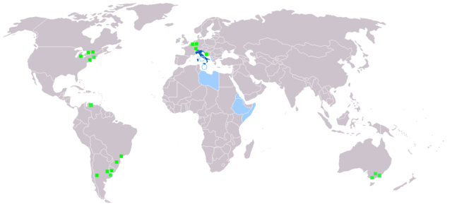
Deutsch: Legende:
Muttersprache
Amtssprache
Zweit- oder nicht offizielle Sprache
Italienischsprachige Minderheiten English: Legend:
Native language
Administrative language
Secondary language or non-official.
Italophone minorities Español: Leyenda:
Lengua materna
Lengua administrativa
Segunda lengua o lengua no oficial.
Minorías italofonas Français : Carte du monde où on parle l'italien.
Langue maternelle
Langue administrative
Langue importante et/ou langue de culture
Minorités italophones Italiano: Legenda:
Lingua madre
Lingua amministrativa
Seconda lingua o lingua non ufficiale
Minoranze italofone Português: Legenda:
Idioma materno
Idioma administrativo
Idioma secundário, ou não-oficial
Minorias italófonas Polski: Legenda:
Włoski jest językiem ojczystym
Włoski jest językiem urzędowym
Włoski jest drugim lub nieoficjalnym językiem
Mniejszości włoskojęzyczne |
| Izvor | |
| Autor |
Licenciranje

|
Data je dozvola da se kopira, distribuira i/ili menja ovaj dokument pod uslovima GNU-ove licence za slobodnu dokumentaciju, verzije 1.2 ili bilo koje novije verzije koju objavi Zadužbina za slobodni softver; bez nepromenljivih odeljaka i bez teksta na naslovnoj i zadnjoj strani. Tekst licence možete pročitati ovde. |
| Ova datoteka je dostupna pod licencom Creative Commons Autorstvo-Deliti pod istim uslovima 3.0 Unported. | ||
| ||
| Ova licenca je dodata na ovu datoteku kao deo ažuriranja GFDL licence. |
Istorija datoteke
Kliknite na datum/vreme da biste videli tadašnju verziju datoteke.
| Datum/vreme | Minijatura | Dimenzije | Korisnik | Komentar | |
|---|---|---|---|---|---|
| trenutna | 21:40, 27. januar 2022. | | 1.357 × 628 (55 kB) | Jacob300 | Updated Somaliland - Italian was never an official language here |
| 20:25, 29. jul 2021. |  | 1.357 × 628 (29 kB) | MMMM fan | Reverted to version as of 14:07, 3 July 2006 (UTC) Removing outdated or inaccurate Italophone minorities | |
| 11:36, 7. mart 2018. |  | 1.357 × 628 (36 kB) | Maphobbyist | Montenegro and South Sudan borders | |
| 22:22, 5. februar 2014. |  | 1.357 × 628 (39 kB) | Mr. Lama | {{SVG|map}} == {{int:filedesc}} == Map made from Image:BlankMap-World.png {{de|Legende: *Dunkelblau: Muttersprache *Blau: Amtssprache *Hellblau: Zweit- oder nicht offizielle Sprache *Grüne Quadrate: Italienischsprachige Minderheiten}} {{en|Lege... | |
| 16:07, 3. jul 2006. |  | 1.357 × 628 (29 kB) | Fsolda~commonswiki | == Summary == Map made from Image:BlankMap-World.png {{en|Legend: *Dark blue: native language *Blue: administrative language *Light blue: Secondary language or non-official. *green square: italophone minorities}} {{es|Legenda: *azul oscuro: lengua |
Upotreba datoteke
Nema stranica koje koriste ovu datoteku.
Globalna upotreba datoteke
Drugi vikiji koji koriste ovu datoteku:
- Upotreba na ab.wikipedia.org
- Upotreba na en.wikipedia.org
- Upotreba na it.wikipedia.org
- Upotreba na lv.wikipedia.org
- Upotreba na nl.wikipedia.org
- Upotreba na pnb.wikipedia.org