
Датотека:Moesia - AD 400.png
Veličina ovog prikaza: 800 × 554 piksela. 3 druge rezolucije: 320 × 222 piksela | 640 × 444 piksela | 860 × 596 piksela.
Originalna datoteka (860 × 596 piksela, veličina datoteke: 756 kB, MIME tip: image/png)
| Ovo je datoteka sa Vikimedijine ostave. Informacije sa njene stranice sa opisom prikazane su ispod. Vikimedijina ostava je skladište slobodno licenciralnih multimedijalnih datoteka. I Vi možete da pomognete. |
Opis izmene
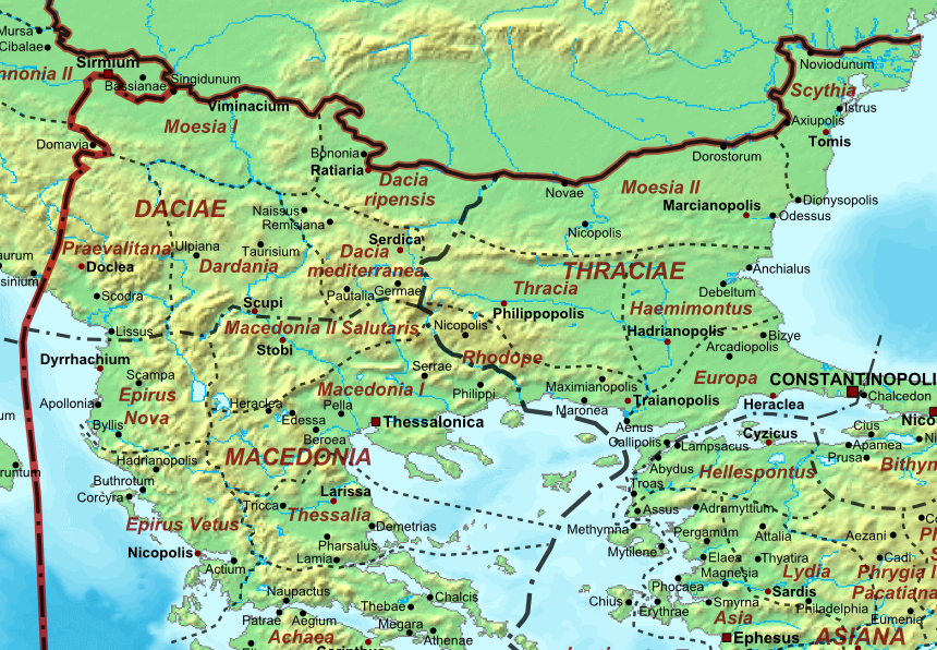
| Opis | Map of the Roman Empire ca. 400 AD, showing the administrative division into dioceses and provinces, as well as the major cities. The demarcation between Eastern and Western Empires is noted in red. |
| Datum | (UTC) |
| Izvor |
This file was derived from: The Roman Empire ca 400 AD.png: |
| Autor |
|
| Ово је ретуширана слика, што значи да је дигитално измењена у односу на своју изворну верзију. Измене: Moesia. Изворна верзија се може видети овде: The Roman Empire ca 400 AD.png. Измене је направио: Jbribeiro.
|
Licenciranje
Ja, nosilac autorskog prava nad ovim delom, objavljujem isto pod sledećom licencom:
| Ja, tvorac ovog dela, predajem ga u javno vlasništvo. Ovo se odnosi na ceo svet. U nekim zemljama, ovo nije zakonski moguće; u tom slučaju: Ja, tvorac ovog dela dozvoljavam svakome da koristi ovo delo za bilo koju namenu, bez bilo kakvih uslova, osim uslova koje nameće zakon. |
Prvobitan dnevnik otpremanja
This image is a derivative work of the following images:
- File:The_Roman_Empire_ca_400_AD.png licensed with PD-self
- 2011-07-21T13:03:22Z Cplakidas 4339x2689 (11429663 Bytes) fixed Persian border, differentiated between Eastern and Western empire, different borders for praet. prefectures
- 2009-03-21T02:37:17Z Cplakidas 4475x2600 (10476876 Bytes) minor corrections
- 2008-05-29T12:30:03Z Cplakidas 3800x2370 (8491181 Bytes)
- 2008-05-29T12:17:05Z Cplakidas 4560x2850 (11764337 Bytes) clearer version & addition of the Armenian satrapies
- 2007-12-30T02:02:48Z Cplakidas 3380x2120 (6247724 Bytes) added names of dioceses, legend box, various minor adjustments
- 2007-12-13T14:27:35Z Cplakidas 3550x2200 (6970232 Bytes) new improved version made with Inkscape, slight corrections in borders, added several cities in Africa & Spain
- 2007-11-12T19:27:37Z Cplakidas 3550x2200 (4979411 Bytes) minor corrections in southern Gaul
- 2007-11-05T12:58:04Z Cplakidas 3550x2200 (4977196 Bytes) New version, with some corrections & additions
- 2007-10-31T16:55:48Z Cplakidas 3436x2142 (4722554 Bytes) {{Information |Description=Map of the [[Roman Empire]] ca. 400 AD, showing the administrative division into dioceses and provinces, as well as the major cities. The demarcation between Eastern and Western Empires is noted in
Uploaded with derivativeFX
Istorija datoteke
Kliknite na datum/vreme da biste videli tadašnju verziju datoteke.
| Datum/vreme | Minijatura | Dimenzije | Korisnik | Komentar | |
|---|---|---|---|---|---|
| trenutna | 22:10, 25. decembar 2013. | | 860 × 596 (756 kB) | Jbribeiro1 | == {{int:filedesc}} == {{Information |Description=Map of the Roman Empire ca. 400 AD, showing the administrative division into dioceses and provinces, as well as the major cities. The demarcation between Eastern and Western Empires is noted in red.... |
Upotreba datoteke
4 sledeće stranice koriste ovu datoteku:
Globalna upotreba datoteke
Drugi vikiji koji koriste ovu datoteku:
- Upotreba na bg.wikipedia.org
- Upotreba na el.wikipedia.org
- Upotreba na en.wikipedia.org
- Upotreba na hu.wikipedia.org
- Upotreba na pt.wikipedia.org