
Датотека:Mollweide Cycle.gif
Veća rezolucija nije dostupna.
Mollweide_Cycle.gif (720 × 360 piksela, veličina datoteke: 4,33 MB, MIME tip: image/gif, petlja, 60 kadrova, 6,0 s)
| Ovo je datoteka sa Vikimedijine ostave. Informacije sa njene stranice sa opisom prikazane su ispod. Vikimedijina ostava je skladište slobodno licenciralnih multimedijalnih datoteka. I Vi možete da pomognete. |
Opis izmene
| Opis |
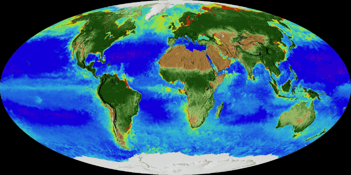
English: On land, vegetation appears on a scale from brown (low vegetation) to dark green (lots of vegetation); at the ocean surface, phytoplankton are indicated on a scale from purple (low) to yellow (high). This visualization was created with data from satellites including SeaWiFS, and instruments including the NASA/NOAA Visible Infrared Imaging Radiometer Suite and the Moderate Resolution Imaging Spectroradiometer.
Français : Cycle annuel de l'enneigement et de la végétation : sur la terre ferme, la végétation apparaît sur une échelle allant du brun (végétation faible ou basse) au vert foncé (végétation dense) ; à la surface de l’océan, la densité en phytoplancton figure sur une échelle allant du violet (faible) au jaune (élevée). Cette visualisation a été créée à l'aide de données provenant de plusieurs satellites, notamment SeaWiFS, et d'instruments tels que la suite de radiomètres infrarouges visibles NASA / NOAA et le spectroradiomètre imageur à résolution moyenne. |
| Datum | |
| Izvor | NASA's Goddard Space Flight Center |
| Autor | NASA's Goddard Space Flight Center |
Licenciranje
| Ова датотека је у јавном власништву зато што је њен аутор НАСА. НАСА-а политика ауторских права наводи „Материјали НАСА-е нису заштићени ауторским правима осим ако није другачије наведено“. (Погледајте Template:PD-USGov, NASA copyright policy page или JPL Image Use Policy.) | ||
 |
Упозорења:
|
Istorija datoteke
Kliknite na datum/vreme da biste videli tadašnju verziju datoteke.
| Datum/vreme | Minijatura | Dimenzije | Korisnik | Komentar | |
|---|---|---|---|---|---|
| trenutna | 12:18, 15. novembar 2017. | | 720 × 360 (4,33 MB) | Originalwana | User created page with UploadWizard |
Upotreba datoteke
Sledeća stranica koristi ovu datoteku:
Globalna upotreba datoteke
Drugi vikiji koji koriste ovu datoteku:
- Upotreba na ar.wikipedia.org
- Upotreba na az.wikipedia.org
- Upotreba na en.wikipedia.org
- Upotreba na eu.wikipedia.org
- Upotreba na fr.wikipedia.org
- Upotreba na gl.wikipedia.org
- Upotreba na ja.wikipedia.org
- Upotreba na jv.wikipedia.org
- Upotreba na ko.wikipedia.org
- Upotreba na mdf.wikipedia.org
- Upotreba na no.wikipedia.org
- Upotreba na tr.wikipedia.org
- Upotreba na uz.wikipedia.org
- Upotreba na vi.wikipedia.org
- Upotreba na zh.wikipedia.org