
Датотека:Pascatway River New England.jpg
Originalna datoteka (3.440 × 2.448 piksela, veličina datoteke: 749 kB, MIME tip: image/jpeg)
| Ovo je datoteka sa Vikimedijine ostave. Informacije sa njene stranice sa opisom prikazane su ispod. Vikimedijina ostava je skladište slobodno licenciralnih multimedijalnih datoteka. I Vi možete da pomognete. |
Opis izmene
| Opis |
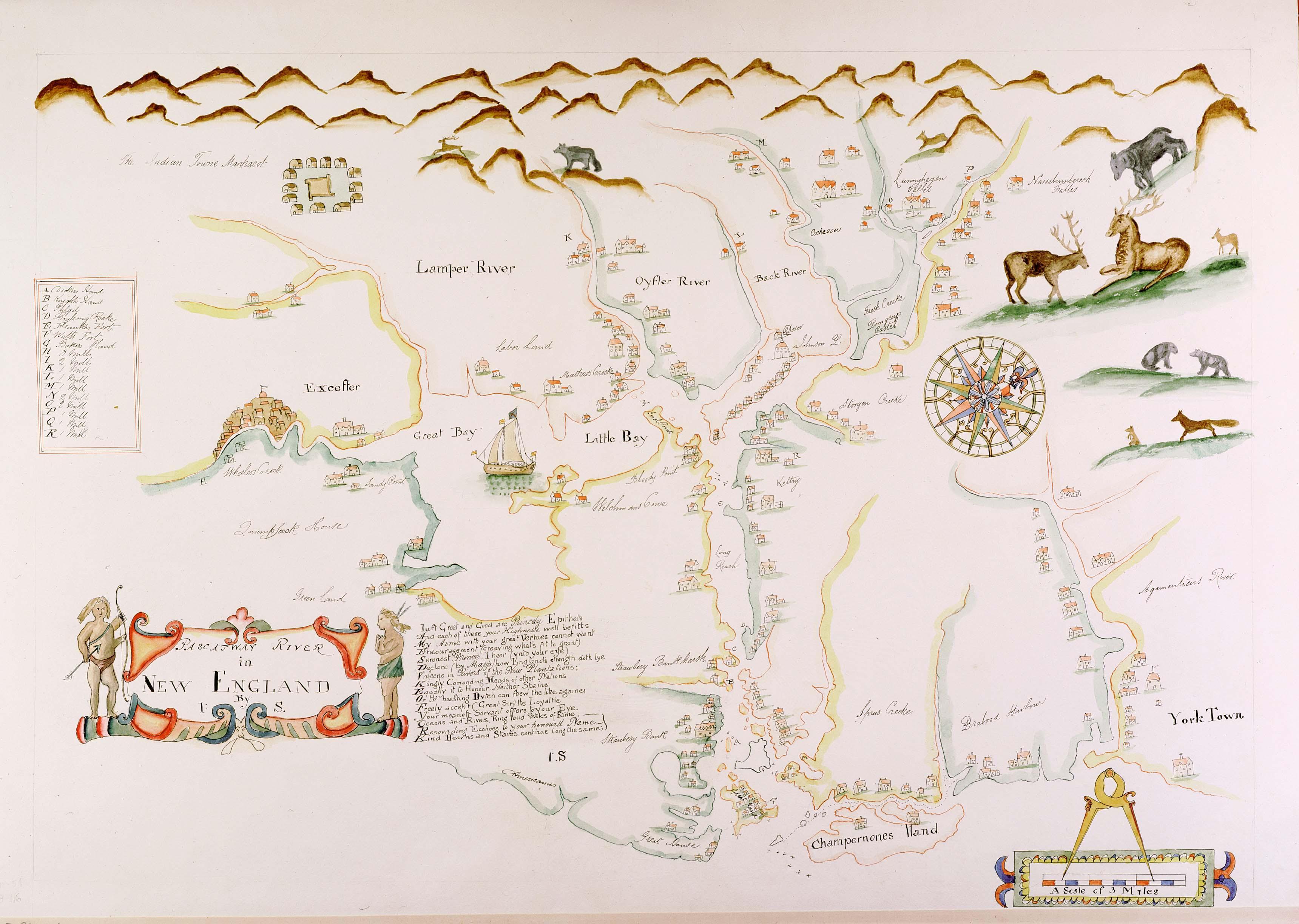
English: Maine historian James Phinney Baxter commissioned the map to be copied from the original in the late 19th century. The original surveyor and creator of the map is unknown, except that the original map carries the initials 'J.S.' from its creator. The map was apparently created during the tenure of King Charles II of England's brother James as the Duke of York, which places its creation sometime around 1670. The map shows the region of the Piscataqua River. Courtesy of the Maine State Archives. Retouched by MarmadukePercy |
| Datum | circa 1670 |
| Izvor | http://www.mainememory.net/bin/Detail?ln=6665 |
| Autor | Nepoznat |
Licenciranje
|
Овај рад је такође у јавном власништву у државама са роком ауторства за живота аутора плус 70 година или мање.
| |
| Utvrđeno je da ova datoteka nije ograničena u pogledu autorskih prava, uključujući i sva srodna i susedna prava. | |
Istorija datoteke
Kliknite na datum/vreme da biste videli tadašnju verziju datoteke.
| Datum/vreme | Minijatura | Dimenzije | Korisnik | Komentar | |
|---|---|---|---|---|---|
| trenutna | 14:28, 7. mart 2010. | | 3.440 × 2.448 (749 kB) | Justass | resolution |
| 00:58, 6. mart 2010. |  | 500 × 334 (91 kB) | MarmadukePercy | {{Information |Description={{en|1=Maine historian James Phinney Baxter commissioned the map to be copied from the original in the late 19th century. The original surveyor and creator of the map is unknown, except that the original map carries the initials |
Upotreba datoteke
Sledeća stranica koristi ovu datoteku:
Globalna upotreba datoteke
Drugi vikiji koji koriste ovu datoteku:
- Upotreba na arz.wikipedia.org
- Upotreba na en.wikipedia.org
- Upotreba na es.wikipedia.org
- Upotreba na ga.wikipedia.org
- Upotreba na hu.wikipedia.org
- Upotreba na ko.wikipedia.org
- Upotreba na la.wikipedia.org
- Upotreba na uk.wikipedia.org