
Датотека:Port Phillip 10,000.PNG
Veća rezolucija nije dostupna.
Port_Phillip_10,000.PNG (514 × 523 piksela, veličina datoteke: 20 kB, MIME tip: image/png)
| Ovo je datoteka sa Vikimedijine ostave. Informacije sa njene stranice sa opisom prikazane su ispod. Vikimedijina ostava je skladište slobodno licenciralnih multimedijalnih datoteka. I Vi možete da pomognete. |

|
This file was moved to Wikimedia Commons from en.wikipedia using a bot script. All source information is still present. It requires review. Additionally, there may be errors in any or all of the information fields; information on this file should not be considered reliable and the file should not be used until it has been reviewed and any needed corrections have been made. Once the review has been completed, this template should be removed. For details about this file, see below. Check now! |
Opis izmene
| Opis |
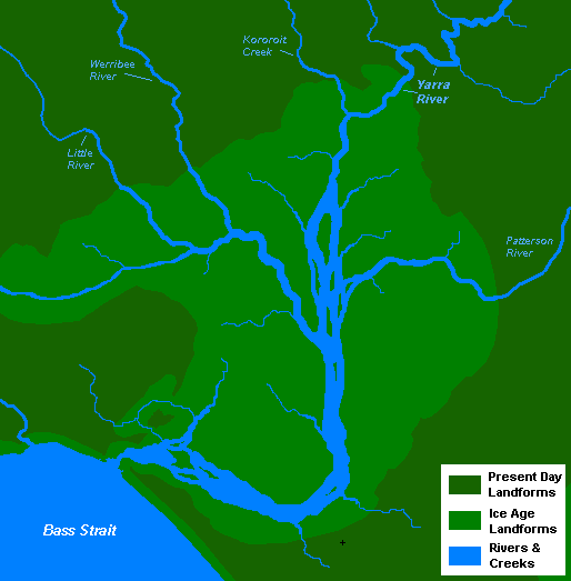
English: A very basic map of the port phillip plains approximately 10-12 thousand years ago, prior to sea level rise that filled the area of land now known as Port Phillip, and the course of the Yarra River as it emptied into Bass Strait. More exact details regarding the course of the Yarra River in the port phillip plains are needed. |
| Datum | 13. novembar 2008. (првобитни датум слања) |
| Izvor | Sopstveno delo |
| Autor | Nick carson на English Vikipedija |
Licenciranje
| Ovo delo je njen nosilac autorskih prava Nick carson на English Vikipedija predao u javno vlasništvo. Ovo se odnosi na ceo svet. U nekim zemljama, ovo nije zakonski moguće; u tom slučaju: Nick carson tvorac ovog dela dozvoljava svakome da koristi ovo delo za bilo koju namenu, bez bilo kakvih uslova, osim uslova koje nameće zakon. |
Prvobitan dnevnik otpremanja
The original description page was here. All following user names refer to en.wikipedia.
- 2008-11-13 14:20 Nick carson 514×523 (20321 bytes) A very basic map of the port phillip plains approximately 10-12 thousand years ago, prior to sea level rise that filled the area of land now known as Port Phillip, and the course of the Yarra River as it emptied into Bass Strait. More exact details regard
Istorija datoteke
Kliknite na datum/vreme da biste videli tadašnju verziju datoteke.
| Datum/vreme | Minijatura | Dimenzije | Korisnik | Komentar | |
|---|---|---|---|---|---|
| trenutna | 21:12, 7. januar 2012. | | 514 × 523 (20 kB) | BotMultichillT | {{BotMoveToCommons|en.wikipedia|year={{subst:CURRENTYEAR}}|month={{subst:CURRENTMONTHNAME}}|day={{subst:CURRENTDAY}}}} == {{int:filedesc}} == {{Information |description={{en|1=A very basic map of the port phillip plains approximately 10-12 thousand years |
Upotreba datoteke
Sledeća stranica koristi ovu datoteku:
Globalna upotreba datoteke
Drugi vikiji koji koriste ovu datoteku:
- Upotreba na af.wikipedia.org
- Upotreba na en.wikipedia.org
- Upotreba na zh.wikipedia.org