
Датотека:RomaniaBorderHistoryAnnimation 1859-2010.gif
Veličina ovog prikaza: 696 × 599 piksela. 3 druge rezolucije: 279 × 240 piksela | 558 × 480 piksela | 1.000 × 861 piksela.
Originalna datoteka (1.000 × 861 piksela, veličina datoteke: 162 kB, MIME tip: image/gif, petlja, 12 kadrova, 36 s)
| Ovo je datoteka sa Vikimedijine ostave. Informacije sa njene stranice sa opisom prikazane su ispod. Vikimedijina ostava je skladište slobodno licenciralnih multimedijalnih datoteka. I Vi možete da pomognete. |
Opis izmene
| Opis |
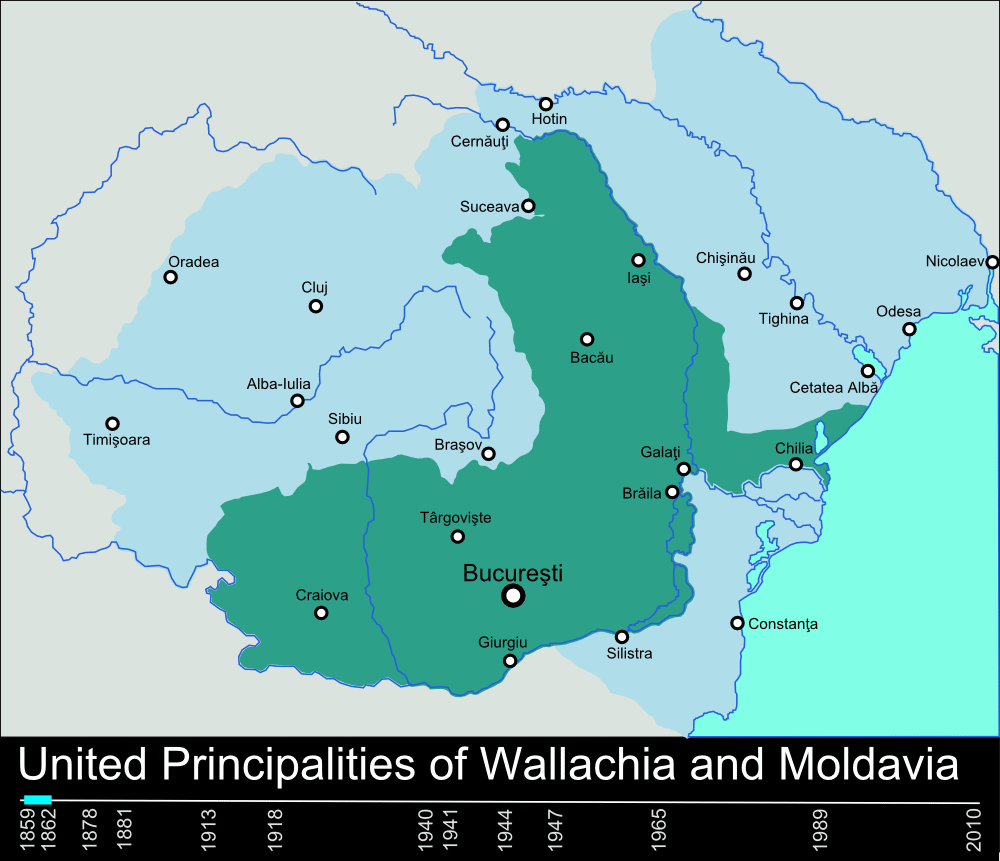
English: Timeline of the borders of Romania between 1859 and 2010. |
| Datum | 11. januar 2010. (првобитни датум слања) |
| Izvor | self-made, individual frames were based on maps from here: Atlas of Romania. (I could upload standalone maps for each period of time, if needed. Contact me for that.). |
| Autor | User:Scooter20 |
| Ostale verzije | Derivative works of this file: RomaniaBorderHistoryAnnimation 1859-2010 es.gif |
Licenciranje
| Ovo delo je njen nosilac autorskih prava Scooter20 на English Vikipedija predao u javno vlasništvo. Ovo se odnosi na ceo svet. U nekim zemljama, ovo nije zakonski moguće; u tom slučaju: Scooter20 tvorac ovog dela dozvoljava svakome da koristi ovo delo za bilo koju namenu, bez bilo kakvih uslova, osim uslova koje nameće zakon. |
Prvobitan dnevnik otpremanja
Transferred from en.wikipedia to Commons by Rowanwindwhistler using CommonsHelper.
The original description page was here. All following user names refer to en.wikipedia.
- 2010-01-11 22:17 Scooter20 1000×861× (166899 bytes) Reverted to version as of 12:48, 31 December 2009
- 2010-01-10 21:53 Alexandrey 1000×861× (152174 bytes) Reverted to version as of 19:31, 30 December 2009
- 2010-01-10 21:52 Alexandrey 1000×861× (166932 bytes) Reverted to version as of 12:29, 31 December 2009
- 2009-12-31 12:48 Scooter20 1000×861× (166899 bytes) fixed Hertza region, which didn't belong to Romania after 1944
- 2009-12-31 12:29 Scooter20 1000×861× (166932 bytes) Added new intervals: 1862-1878, 1878-1881 - United Romanian Principalities 1947-1965 - People's Republic of Romania
- 2009-12-31 00:57 Scooter20 1000×861× (153234 bytes) fixed location of the city of Sibiu
- 2009-12-30 19:31 Scooter20 1000×861× (152174 bytes) Timeline of the borders of Romania between 1859 and 2010.
Istorija datoteke
Kliknite na datum/vreme da biste videli tadašnju verziju datoteke.
| Datum/vreme | Minijatura | Dimenzije | Korisnik | Komentar | |
|---|---|---|---|---|---|
| trenutna | 00:02, 10. mart 2012. | | 1.000 × 861 (162 kB) | Scooter20 | Better colors! |
| 18:07, 8. septembar 2010. |  | 1.000 × 861 (168 kB) | Mihai Andrei | Corrected the name of the city of Cluj for the period until 1975. | |
| 02:09, 4. septembar 2010. |  | 1.000 × 861 (163 kB) | Anonimizat XXX | (I tried to revert to the version from april 2010 but it didn't work, so I've decided to manually upload again) | |
| 02:02, 4. septembar 2010. |  | 1.000 × 861 (163 kB) | Anonimizat XXX | Reverted to version as of 20:45, 21 April 2010 (animation broken, also, the name of Cluj is actually Cluj-Napoca as the original gif indicate) | |
| 20:02, 9. avgust 2010. |  | 1.000 × 861 (73 kB) | Mihai Andrei | Corrected the name of the city of Cluj. | |
| 22:45, 21. april 2010. |  | 1.000 × 861 (163 kB) | File Upload Bot (Magnus Manske) | {{BotMoveToCommons|en.wikipedia|year={{subst:CURRENTYEAR}}|month={{subst:CURRENTMONTHNAME}}|day={{subst:CURRENTDAY}}}} {{Information |Description={{en|Timeline of the borders of Romania between 1859 and 2010.<br/> == Other versions == [[:en:Image:Flag_of |
Upotreba datoteke
4 sledeće stranice koriste ovu datoteku:
Globalna upotreba datoteke
Drugi vikiji koji koriste ovu datoteku:
- Upotreba na af.wikipedia.org
- Upotreba na ar.wikipedia.org
- Upotreba na ary.wikipedia.org
- Upotreba na ast.wikipedia.org
- Upotreba na azb.wikipedia.org
- Upotreba na bcl.wikipedia.org
- Upotreba na da.wikipedia.org
- Upotreba na de.wikipedia.org
- Upotreba na el.wikipedia.org
- Upotreba na en.wikipedia.org
- Romania
- History of Romania
- Former administrative divisions of Romania
- Kingdom of Romania
- Romanians
- Administrative divisions of Romania
- User:Scooter20
- Union of Transylvania with Romania
- User:Iadrian yu
- User talk:Iadrian yu/Archive April,2010
- Territorial evolution of Romania
- 2010 in Romania
- User:Falcaorib/Romania and Moldova
- Upotreba na et.wikipedia.org
- Upotreba na eu.wikipedia.org
- Upotreba na fa.wikipedia.org
- Upotreba na fi.wikipedia.org
- Upotreba na it.wikipedia.org
- Upotreba na ja.wikipedia.org
- Upotreba na ka.wikipedia.org
- Upotreba na lv.wikipedia.org
- Upotreba na mk.wikipedia.org
- Upotreba na no.wikipedia.org
- Upotreba na pt.wikipedia.org
- Upotreba na ro.wikibooks.org
- Upotreba na ru.wikipedia.org
Još globalnog korišćenja ove datoteke.